Virginia
![]()
| CNY Hiking HOME PAGE | Blue Ridge Parkway | North Carolina BRP Highlights |
|
Blue Ridge Parkway Virginia
|

In Virginia, the Parkway highlights the rolling agricultural scenery that is so much a part of the Blue Ridge. The main story is how humans have interacted with the land in these mountains. Visitors are introduced to a variety of cultural sites and landscapes associated with communities in the southern Appalachians including evidence of human occupation from prehistoric to contemporary times.
Early stories of tourism in the mountains and examples of arts, crafts, music, and social institutions of the region make a visit to the Virginia section of the Parkway one filled with lasting memories. Much of the road travels through US National Forest lands as well and, north of Roanoke, the drive is dominated by a ridge-top experience with magnificent views of the flora and fauna of Appalachian hardwood forests and sweeping vistas of the Great Valley of Virginia.
Look below for milepost by milepost highlights along the Parkway in Virginia with links so you can explore even further. By clicking on the thumbnail pictures, you'll get a larger picture.
Milepost Elevation Highlights along Blue Ridge Parkway in Virginia (north to south)
0.0 1909 ft Rockfish Gap - US 250/I-64 and Skyline Dr Jct. Waynesboro, VA is 4 miles west. 0.2 2054 ft Afton Overlook 2.0 2148 ft Rockfish Valley Overlook 2.2 2170 ft VA 610 - Appalachian Trail access 2.9 2354 ft Shenandoah Valley Overlook 4.4 n/a VA 609 JCT 5.8 2353 ft Humpback Rocks Visitor Center. Restrooms, Souvenir Store. HIKE - Self-Guiding Mountain Farm Trail. 6.1 2360 ft Humpback Gap Overlook and Parking Area. HIKE - 1 mile to The Rocks & 2.2 miles to Humpback Mountain. 8.5 n/a Humpback Rocks Picnic Area - 91 sites and 2 comfort stations. HIKE - 0.3 miles to Catoctin View. Two miles to Humpback Mountain or 3 miles to Humpback Rocks.
8.8 3007 ft Greenstone Overlook. HIKE - Self-Guiding Greenstone Trail
(0.2 mile). VIEWS
9.2 2878 ft Laurel Springs Gap 9.6 2940 ft Dripping Rock Parking Area - Appalachian Trail Crossing. HIKE - AT south 0.4 miles to Cedar Cliffs for great views. You can continue south on AT for another 1.1 miles to Ravens Roost for more views. If you do both hikes it's a 3.0 mile round trip. It's only 0.8 mile roundtrip for just the Cedar Cliffs hike. 10.4 3113 ft Rockpoint Overlook. 10.7 3200 ft Ravens Roost Overlook 11.7 2940 ft Hickory Spring Parking Area 13.1 2697 ft Three Ridges Overlook 13.7 2637 ft Reeds Gap - Appalachian Trail access. VA 664 & VA 814 JCT. 15.4 2597 ft Love Gap - Appalachian Trail access via Fire Road leads to Maupin Field Shelter 16.0 2700 ft VA 814 - Sherando Lake Recreational Area is 4.5 miles to the west. 17.6 2695 ft The Priest Overlook 18.5 2549 ft White Rock Gap. Small parking area for the White Rocks Falls Trail. (1.6 miles to falls) 19.0 2715 ft Twenty Minute Cliff Overlook 19.9 2800 ft The Slacks Overlook 22.1 3250 ft Bald Mountain Overlook 23.0 3294 ft Fork Mountain Overlook - Access to St Mary's Wilderness 23.4 3334 ft Highest point on parkway north of the James River. 25.6 3033 ft Spy Run Gap 26.4 3200 ft Big Spy Overlook. HIKE - The 0.1 mile Big Spy Trail leads up a gentle grassy hill & loops back to parking area. VIEWS 27.2 2969 ft Tye River Gap. VA 56 JCT. Steeles Tavern, VA is 6 miles west. Six miles east is trailhead for Crabtree Falls. 29.0 3000 ft Whetstone Ridge. 31.4 3000 ft Stillhouse Hollow Parking Area 34.4 3140 ft Yankee Horse Parking Area 
37.4 2200 ft Irish Gap. 37.5 2200 ft VA 605 JCT. 38.8 2523 ft Boston Knob Overlook 40.0 2177 ft Clarks Gap. 42.4 2665 ft View Irish Creek Valley 44.4 2567 ft White's Gap Overlook 44.9 2485 ft Chimney Rock Mountain Overlook 45.6 2312 ft Humphreys Gap. US 60 JCT. Buena Vista, VA is 4 miles west. 45.7 2325 ft View Buena Vista. 47.5 2098 ft Indian Gap Parking Area. The 0.2 mile Indian Gap Trail is a loop leading to some interesting truck size boulders. 48.9 2481 ft Licklog Springs Gap 49.3 2498 ft House Mountain Overlook 50.1 2412 ft Robinson Gap 51.5 n/a Appalachian Trail access. Parking. HIKE - AT south to Bluff Mountain (VIEWS, Strenuous, 3.5 mile roundtrip) 52.8 1850 ft Bluff Mountain Overlook 53.1 n/a Bluff Mountain Tunnel (630 feet long) 53.6 1755 ft View Rice Mountain 54.1 1560 ft Browns Creek 55.1 1460 ft White Oak Flats Overlook 55.2 1458 ft Otter Creek 
55.9 1300 ft Dancing Creek Overlook 57.6 1085 ft Upper Otter Creek Overlook 58.2 1055 ft Otter Creek Flats Overlook 59.7 885 ft Otter Creek Overlook 60.4 825 ft The Riffles Overlook 60.8 800 ft Otter Creek Recreational Area. Campground, Otter Creek Gift Shop & Restaurant. Otter Creek Trail. 61.4 760 ft Terrapin Hill Overlook 61.6 n/a Otter Creek Bridge. VA 130 JCT. 62.5 685 ft Lower Otter Creek Overlook 63.1 655 ft Otter Lake Overlook. Fishing & Hiking on Otter Lake. Otter Creek Trail. Otter Lake Loop Trail.
63.2 646 ft Lowest point along Blue Ridge Parkway. 63.6 649 ft James River Visitor Center. Rest Rooms, Gift Shop & hiking. 63.7 670 ft James River Bridge 
63.9 680 ft US 501 JCT. Glasgow, VA is 9 miles north and Lynchburg, VA is 15 miles south. James River Face Wilderness. 67.1 n/a Falling Rock Creek. 69.1 1874 ft James River Valley Parking Area Overlook 71.0 2361 ft Petite's Gap. Appalachian Trail access. Cave Mountain Lake Recreational Area is 8 miles west. 72.6 2884 ft View Terrapin Mountain. 74.7 3485 ft Thunder Ridge Overlook 
74.8 3510 ft Thunder Hill 74.9 3515 ft Appalachian Trail access 75.5 3700 ft View Arnold Valley Overlook Appalachian Trail access.
76.3 3883 ft Appalachian Trail access. HIKE - AT south to Apple Orchard Mtn (1.8 mile round trip) VIEWS 76.5 3933 ft Apple Orchard Mountain Overlook 76.7 3950 ft Highest Point on Blue Ridge Parkway in Virginia. 
78.4 3472 ft Sunset Field Overlook. Apple Orchard Falls Trail leads 1.4 miles down to 150' waterfalls. Appalachian Trail access. 79.7 3145 ft Onion Mountain Overlook 79.9 3195 ft View Black Rock Hill. 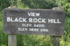
80.5 3187 ft USFS Road 190 crossing. Appalachian Trail access to Cornelius Creek Shelter. 81.9 2861 ft View Headforemost Mountain. Water fountain. 83.1 2560 ft Fallingwater Cascades Parking Area. HIKE - The Fallingwater Cascades Trail. Entering Peaks of Otter Recreational Area. 83.5 2511 ft Wilkinson Gap. 83.6 2610 ft Flat Top Trail Overlook. Flat Top Mountain Trail. 85.6 2525 ft Peaks of Otter Lodge/Restaurant & gift shop. Restrooms. HIKE - Abbott Lake Loop Trail (1.0 mile) 85.9 2545 ft Peaks of Otter Visitor Center VA 43 JCT. Camping, Camp Store, rest rooms, Picnic Area 89.1 1916 ft Powell's Gap - North Creek Campground is ten miles away. 89.4 1925 ft View Upper Goose Creek Valley Overlook 90.0 2102 ft View Porter's Mountain 90.9 2258 ft Bearwallow Gap. VA 43 JCT. West 5 miles to Buchanan, VA. Appalachian Trail access. 91.8 2435 ft Mills Gap Parking Area 91.9 2525 ft Mills Gap 92.1 2415 ft View Purgatory Mountain 92.5 2415 ft Sharp Top Parking Area. Appalachian Trail access. Appalachian Trail Wayside Exhibit. 93.1 2418 ft Boblett's Gap Overlook. Appalachian Trail access. 93.2 n/a Bobblets Gap. Appalachian Trail access. Bobblets Gap Shelter just south on AT. 94.1 n/a Hammond Trail. Appalachian Trail access. 95.2 2490 ft Pine Tree Overlook 95.3 2524 ft Harvey's Knob Overlook. Appalachian Trail access. 95.9 2441 ft View Montvale Town 96.0 n/a Spec Mine Trail (2.8 miles one way). 96.2 2364 ft Iron Mine Hollow 96.4 2372 ft Iron Mine Hollow 97.0 2340 ft View Taylor's Mountain. Appalachian Trail access. 97.7 2402 ft Black Horse Gap. Last time on BRP for Appalachian Trail access. 99.6 2493 ft The Great Valley Overlook 100.9 2170 ft Quarry Overlook 
101.5 1985 ft Curry Gap - USFS Road 191 crossing. Right to AT and Fullhardt's Knob. 105.8 1133 ft US 460 JCT. West 9 miles to Roanoke, VA. 106.9 1151 ft N & W Railroad Overlook. Notice how civilization is appearing at this overlook. 107.0 1150 ft View Coyner Mountain. This overlook seems to be overgrown. 109.8 1163 ft Read Mountain Overlook 110.6 1275 ft Stewarts Knob Overlook. Stewarts Knob Trail (0.1 mile) leads to a bench. Start of the Roanoke Recreational Area 112.2 n/a VA 24 JCT. West 5 miles to Roanoke, VA. Good spot to get gas. 112.9 1000 ft View Roanoke Basin Overlook 114.7 825 ft Roanoke River Bridge 114.9 985 ft Roanoke River Overlook. Roanoke River Trail (0.4 mile) Roanoke Recreational Area 115.0 n/a Virginia's Explorer Park Spur Road. Visitor Center, Restrooms, Hiking, Brugh Tavern. NOTE: The Virginia Recreational Facilities Authority or “VRFA” – Virginia’s Explore Park’s governing board of directors – ceased regular operations of Explore Park on November 30, 2007. The Blue Ridge Parkway Visitor Center, including its gift shop and exhibits, remains open on a seasonal basis. Roanoke Recreational Area 120.3 n/a Roanoke Mountain Loop Rd. Four mile loop road leads to top of Roanoke Mountain. Roanoke Recreational Area 120.4 n/a Mill Mountain Spur Rd. Campground, Chestnut Ridge Trail, Zoo, Roanoke Star. Roanoke Recreational Area 121.4 n/a US 220 JCT. West 5 miles to Roanoke, VA. 123.2 1465 ft Buck Mountain Overlook. Buck Mountain Trail A 0.5 mile moderate hike leads to a bench. 124.4 1160 ft Back Creek 126.6 1425 ft Masons Knob Overlook 128.7 1875 ft Metz Run Overlook 129.3 2032 ft Poages Mill Overlook 129.6 2125 ft Roanoke Valley Overlook 129.9 2200 ft Lost Mountain Overlook 133.0 2860 ft Slings Gap Overlook 133.1 2825 ft Slings Gap 133.6 2890 ft View Bull Run Knob 134.3 2786 ft Lancaster Gap 134.9 2975 ft View Poor Mountain 135.9 2690 ft Adney Gap. US 221 JCT 138.5 2889 ft Sweet Annie Hollow 139.0 3013 ft Cahas Knob Overlook 143.9 2687 ft Devil's Backbone Overlook 
144.8 2703 ft Pine Spur Overlook 149.1 n/a VA 640 - Kelley Schoolhouse. Recently this old schoolhouse was purchased by the National Park Service. 154.1 2564 ft Smart View Overlook 154.5 2564 ft Smart View Recreation Area Picnic Area 
157.6 2806 ft Shortts Knob Overlook 162.4 2477 ft Rakes Mill Pond 
165.3 2752 ft Tuggle Gap. VA 8 JCT. Floyd, VA is six miles north. 167.1 3582 ft Rocky Knob Campground (82 tent sites). 168.0 3880 ft The Saddle Overlook. Self Guiding Trail to an old AT shelter with a view. 
168.8 3195 ft Rock Castle Gorge Overlook. Rock Castle Gorge Trail. 
169.0 n/a Rocky Knob Visitor Center. Picnic Area 169.1 n/a Twelve O'clock Knob Overlook. Rock Castle Gorge Trail 174.1 n/a Rocky Knob Cabins 176.2 2855 ft Mabry Mill. Mabry Mill Restaurant, Gift Shop, Restrooms, Self Guiding Pioneer Industry Trail. 

177.7 2960 ft US 58 JCT. Meadows Of Dan, VA. 179.3 2800 ft Round Meadow Overlook. Round Meadow Creek Loop Trail (0.5 mile) 183.4 2875 ft Pinnacles Of Dan Gap 188.8 3025 ft Groundhog Mountain Overlook. Picnic Area 
189.1 2950 ft View Pilot Mountain Overlook 189.9 2848 ft Puckett Cabin Parking Area. Historic Building. 
199.4 2925 ft US 52 JCT (to I-77) Fancy Gap, VA. 202.8 3015 ft Granite Quarry Overlook 203.9 2900 ft View of Piedmont 
206.1 2759 ft Pipers Gap 206.3 2744 ft VA 97 JCT. West 10 miles to Galax, VA. 213.3 2620 ft Blue Ridge Music Center. Visitor Center, restrooms, museum and hiking trails. 215.8 n/a VA 89 JCT. North 7 miles to Galax, VA. 216.9 n/a Virginia/North Carolina State Line. (see North Carolina Highlights for more Blue Ridge Parkway info).
Follow the links to pictures, hiking maps and more description of the area. (click on pics for larger image)
| CNY Hiking HOME PAGE | Blue Ridge Parkway | North Carolina BRP Highlights |
