Flat Top rises to an elevation of 4,001 feet with many scattered rock outcrops. The Pinnacle and Cross Rock are a couple of those outcrops. This strenuous, 4.4 mile National Recreational Trail travels from the Flat Top Parking Area located at milepost 83.5 on the Blue Ridge Parkway, over the summit of Flat Top to the Peaks of Otter Picnic Area.
Compared to Sharp Top and other trails in the Peaks of Otter Recreational Area, this trail gets much less traffic. You could be the only person on Flat Top, except on weekends. The hike to Flat Top is much more strenuous than the hike to Sharp Top, plus there is no bus ride to the top (like Sharp Top).
Most start the hike to Flat Top from the Peaks of Otter Picnic Area for a 1.8 mile hike to the summit with an elevation gain of over 1600 feet. From the Flat Top Parking Area at milepost 83.5, off the Parkway, it is 2.6 miles to the summit with an elevation gain of just under 1600 feet. There are more views when you take the longer route to the summit, as you pass a rock outcropping called The Pinnacle.
One of many views from Flat Top
From the Flat Top Parking Area, the trail skirts along the Parkway boundary with views of the parkway before beginning a switch backing ascent of the mountain's north side. At 0.5 miles from the trailhead, the trail makes the first of nine sharp switchbacks in front of bench, turning a hard left.
As the trail continues through a boulder field, you can look down to see the part of the trail you were just on a few feet below, and much farther down, the Parkway. You'll work your way through many boulders in here, and then trail bends gradually right so that the parkway is no longer in view. Soon the trail bends even more sharply right to make its second switchback, and you will see Flat Top up and to the left.
Rocks and mountain laurel frame the scene as you continue working gradually uphill. Harkening Hill appears off in the distance. There are many good views to the right here as the trail angles up, clinging to the mountainside. In a field of large boulders, the trail makes it third switchback as it turns left through large rocks among big trees.
The trail heads back to the north side of the mountain, Apple Orchard Mountain and its signature radar tower can be seen to the left. After a hard right turn at switchback number four, the trail works gradually left back to the southwest side of the mountain. You can see the results of the climb more than you will feel it because it is so gradual. Flat Top's summit is visible straight ahead now as you walk through a boulder field. Below the clearing on Harkening Hill, you can see the old Johnson home site and farm, a popular Peaks of Otter attraction.
A hairpin left turn at a little more than a mile from the trailhead, makes switchback number five. The boulders keep getting larger the higher you hike, and the distance between switchbacks also gets shorter, as turn number six bends hard to the right just a few hundred yards farther along. Not too much farther is the seventh switchback on some rock steps. Just past this left twist, a great view opens up between and over trees to the left.
The boulders become more and more impressive. Stacks of them, rounded ones, some as large as small buildings. The views are equally impressive, to the left through here as again the trail visits the north side of the mountain. After a slight curve right, the trail levels out (some minor ups and downs) for a while as it follows the mountainside. Finally angling uphill again, some rhododendron-studded bluffs appear up and to the right.
Before you know it, you're making a right switchback number eight, up to the bluff line and the trail ascends at the steepest angle it has since the trailhead. Then, it bends left for the final switchback to a wooden bench, levels off a little, then rises slightly and to the right, reaching a lovely viewpoint on the left and then reaches the Cross Rock trail spur.
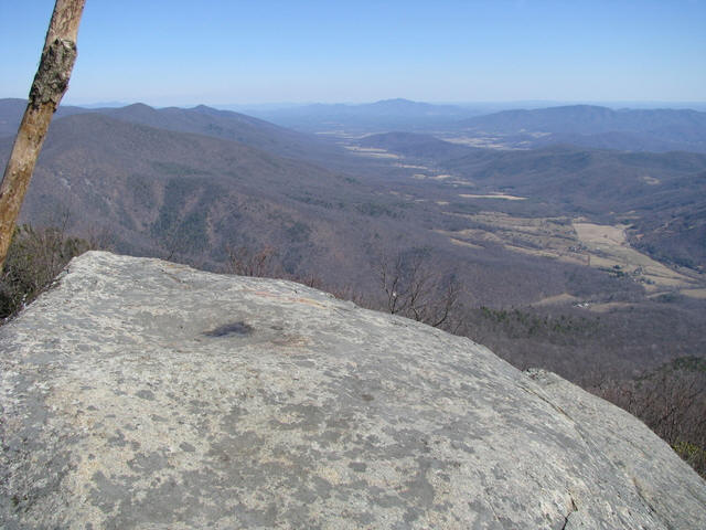
The Cross Rock Trail is a short 0.1 mile trail to a balanced rock formation. The trail is extremely steep and you should take care if you decide to explore this area. Continuing along the Flat Top Trail, the trail ascends through some large boulders to reach a level ridgeline. The trail bends left through some rocks, then right, then climbs to an exposed ridgeline called the Pinnacle. From this rocky ridge there are vistas on both sides.
You quickly learn that Flat Top is not at all flat on top. This part of the trail keeps bobbing up and down to various rocky points and ridgelines, studded with rhododendron, mountain laurel and stunted trees. You wind up through some bluffs on a "S" curve, one of the steepest parts of the trail, but not really that bad. The trail then levels, then climbs a little, then down a bit, then level, then curves upward to a short spur trail off to the left that reaches a flat rock outcropping with good views of the Piedmont toward Bedford and Lynchburg.
After another little climb, you've reached the summit. The sign marks it at 4,001 feet, but actually the high point is up on the rocky mound in the middle. There are many outcroppings that provide good views here. A good place to stay and enjoy the views for a while. Be sure to retrace your steps back to the trailhead. If you continue on the trail from here it's a steep descent to the picnic area that you'll have to climb back up unless you've arranged a shuttle.
While your visiting and exploring the Peaks of Otter Recreational Area, be sure to include a hike to the summit of Flat Top as one of your activities. The hike is strenuous, but well worth the effort. This hike is featured in the hiking guide book Hiking the Blue Ridge Parkway
.