Appalachian Trail to
Apple Orchard Mountain
![]()

| CNY Hiking HOME PAGE | Virginia BRP Highlights | Blue Ridge Parkway |
|
Blue Ridge Parkway Appalachian Trail to Apple Orchard Mountain
|
|

Apple Orchard Mountain was named not for some expanse of apple trees planted on its slopes, but for the nature of the dominant northern red oak forests on its summits and ridges. The weather is so severe on the upper elevations of the mountain that the trees have taken on a stunted appearance, as if they have been trimmed and pruned over the decades. In fact, no human hand has altered them, but Mother Nature has had her way with them by virtue of harsh conditions and the icy winds that rake the peak during the long winter months.
The mountain also has a large FAA antenna on the top. The antenna is the only working remnant of the old Bedford Air Force Base, which operated on the summit from 1954 to 1974. As many as 120 airmen were stationed on the mountain during those years. Just 0.3 miles to the north of the summit is "The Guillotine", a large boulder that 'hangs' above the trail. There are also the 110 rock steps built by the local hiking club.
This moderate four mile round trip hike along the Appalachian Trail is featured in the book The Best of the Appalachian Trail Day Hikes
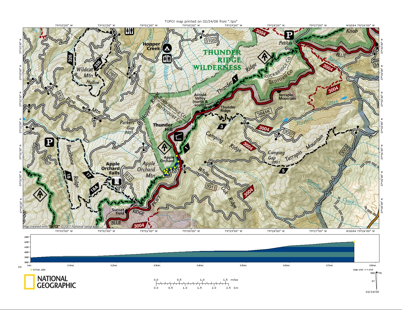
as you'll hike to the 4225 foot summit of Apple Orchard Mountain. There are two options to hike to Apple Orchard Mountain. The book gives you a moderate four mile round trip that starts at the Sunset Fields Overlook of the Blue Ridge Parkway at milepost 78.4.
From Sunset Field, descend following the blue blazed Apple Orchard Falls Trail for 0.25 miles to the junction of the white blazed Appalachian Trail. It's another 1.2 miles to beautiful Apple Orchard Falls, which includes an elevation loss of over 2000 feet (if your interested in a strenuous hike). Turn right onto the white blazed Appalachian Trail and soon climb steps and cross dirt forest road 812.
After crossing the gravel road, you continue your ascent on more steps. The AT winds along the wooded slope of Apple Orchard Mountain for a little over a mile before entering a field on the summit of the mountain at 1.7 miles. The views are spectacular as your at the highest point on the AT north until New Hampshire.
Descending on rock steps the trail takes you past numerous rock formations including the famous Guillotine, which is reached at two miles. Simply retrace your steps back to Sunset Field.
Another option is start from the AT crossing the Parkway at milepost 76.5 (park along the side of the road, making sure your vehicle is off the parkway). This is the easier hike to Apple Orchard Mountain.
From here it is only a 0.9 mile hike to the summit with a 300 foot elevation gain. From the Parkway, follow the white blazes of the Appalachian Trail south. After 0.4 miles the trail enters the edge of an open field for 300 feet.
At 0.6 miles reach The Guillotine and in another 0.2 mile begin an ascent over 110 rock steps and a series of switchbacks to the 4225 foot summit of Apple Orchard Mountain at 0.9 miles. Apple Orchard is the AT's highest elevation between Mt. Moosilauke at 4,802 feet, more than 1,000 miles north in New Hampshire and Chestnut Knob at 4,409 feet almost 200 miles south.
| CNY Hiking HOME PAGE | Virginia BRP Highlights | Blue Ridge Parkway |
