North Country National Scenic Trail
Onondaga Trail
Highland Forest
County Park
![]()
| CNY Hiking HOME PAGE | Hiking in Onondaga County | Highland Forest County Park | NCT in Central New York |
|
Hiking in Onondaga County North Country National Scenic Trail Onondaga Trail Highland Forest County Park
|

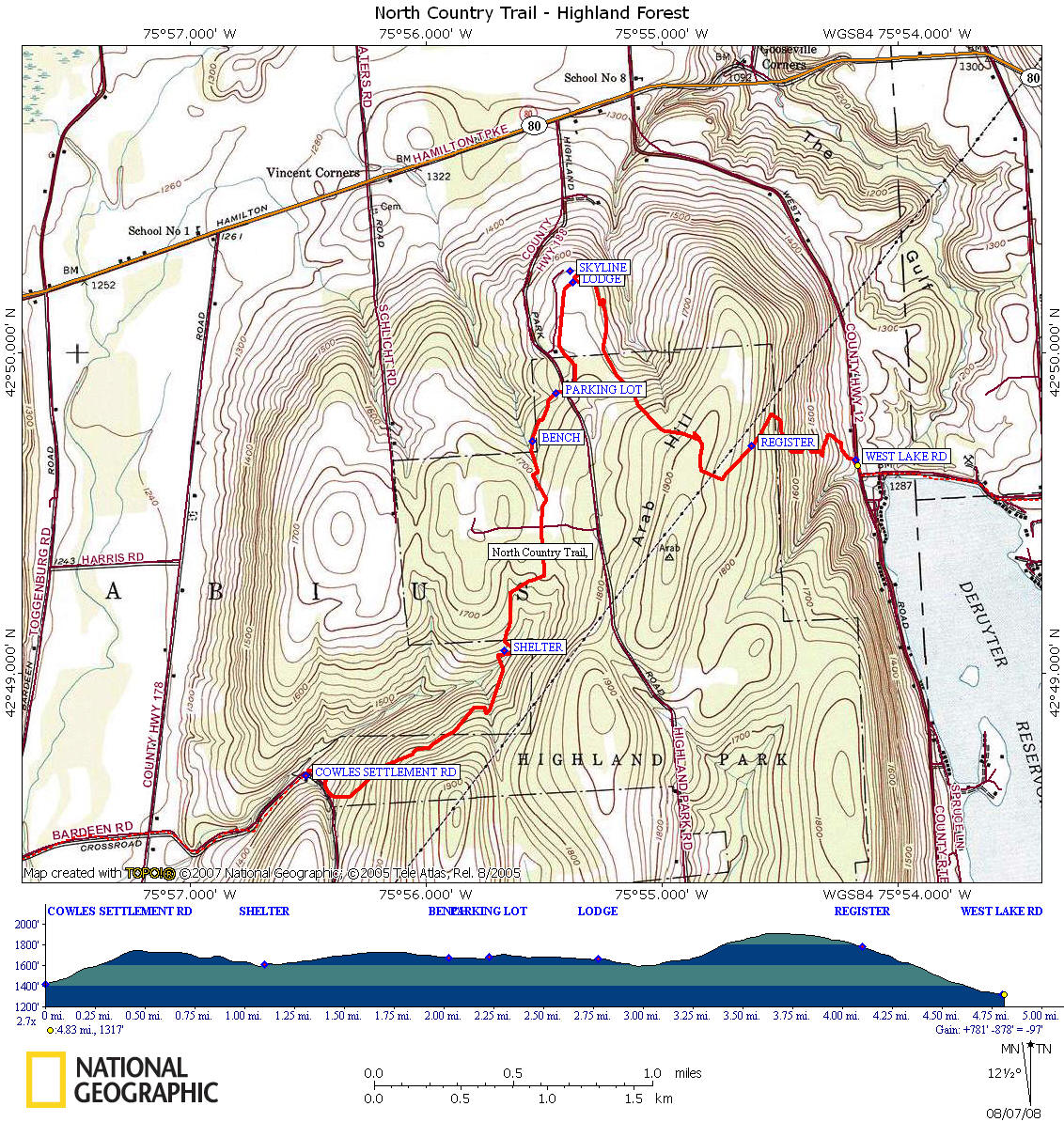
This section of the North Country Trail begins as the trail leaves Cowles Settlement Road (follow the blue blazes) and enters the very popular Highland Forest County Park. Highland Forest County Park has over twenty miles of well maintained hiking trails, as well as the North Country Trail. It's worth the time to explore the park and there are numerous opportunities for short, medium or longer length loop hikes within the park. We highlight a four mile loop hike called the Arab Hill Loop on our website that is just an example of the many loop choices you have.
As the North Country Trail winds into the heart of this large county park, you will cross old woods roads as well as follow some old woods road. At a stream crossing the North Country Trail meets and joins the main park trail. Soon you will cross a stream on a bridge before reaching a day shelter with a picnic table. This is a perfect place to relax before beginning a short climb. The trail turns left at the junction of the park nature trail and soon will reach a bench along the trail. Reach a large parking area and kiosk, then the trail crosses the main park road and briefly follows a park road as it passes some of the park buildings.
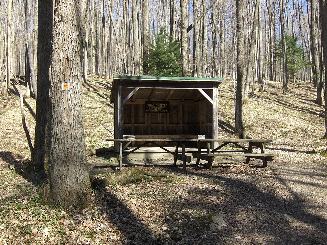
Day use shelter along the NCT in Highland Forest
The trail veers left off the park road and begins its final push toward the main park building, the Skyline Lodge. This is the main parking area for the park. At the lodge there are flush toilets, vending machines as well as park trail maps available. On the left side of the building is a surprising view of the area. The North Country Trail skirts the right side of the building in a field before entering the woods. The NCT is still following the main park trail, but soon the main park trail veers left as the North Country Trail turns right.
Soon cross Limestone Trail and ascend. In another 0.5 mile the main park trail joins as the NCT veers right. In just 0.2 mile the North Country Trail turns sharply left at a double blaze, leaving the main park trail for the last time and soon passes under power lines. There is a trail register before the North Country Trail leaves Highland Forest County Park and enters private property. There is ACTIVE HUNTING on this PRIVATE PROPERTY. Please wear BLAZE and KEEP DOGS LEASHED. Expect hunting from May 1-31 and during big game season in the fall. Now the trail begins a descent along switchbacks toward West Lake Road and Deruyter Lake. This also marks the end of this 4.8 mile section of the North Country National Scenic Trail.
At times the North Country Trail can be tough to follow through the park, especially with all the park trails. Watch the blue blazes carefully. Share
DIRECTIONS: From Fabius, NY 80 East, then turn right on Vincent Corners Rd. At the 4-way intersection turn left on Cowles Settlement Rd. As you come to a sharp right bend in the road there is a small pull off. Park here and you will see the FLT/NCT sign heading into the woods. The GPS coordinates for the parking is N42 48.683 W75 56.495 for those who have a GPS devise. This hike is a 4.8 mile ONE WAY hike. I would recommend that you have a second vehicle either at the Cowles Settlement Rd trailhead or the Dam Rd trailhead. Starting at Dam Rd creates an ascent of nearly 600 feet in only one mile. The Dam Road parking area GPS coordinates are N42 49.634 W75 54.041 for those who have a GPS devise.
Mileage Elevation Description 0.0 1414 feet Trail leaves Cowles Settlement Road and enters Highland Forest County Park. Follow Blue Blazes. GPS coordinates are N42 48.683 W75 56.495
0.9 1688 feet Join main park trail. Turn left.
1.1 1608 feet Cross bridge and pass trail shelter on left.
1.7 1728 feet Junction with park nature trail. North Country Trail turns left, follow blue blazes.
2.0 1674 feet Bench
2.2 1681 feet Trail register, parking lot. Cross main park rd and continue down maintenance rd.
2.4 1693 feet Trail veers to left off dirt road toward "hiking/snowshoe trails" sign.
2.8 1663 feet Reach NCT Kiosk and Skyline Lodge. Views. Trail continues east past lodge.
3.1 1627 feet Main park trail veers left, North Country Trail turns right. Follow blue blazes.
3.2 1655 feet Cross Limestone Trail. Begin to ascend.
3.7 1896 feet Main park trail joins as NCT veers right.
3.9 1889 feet North Country Trail turns left at double blaze & soon passes under power lines.
4.1 1780 feet Trail register.
4.3 1678 feet Leave Highland Forest County Park and enter PRIVATE LAND.
4.8 1321 feet Reach West Lake Rd. NCT crosses road and turns left on Dam Rd. There is a parking area just down on Dam Road a short distance. GPS coordinates N42 49.634 W75 54.041. For a continuation, please see DeRuyter State Forest.
| CNY Hiking HOME PAGE | North Country Trail in CNY | Highland Forest County Park |
| Onondaga Trail | Hiking in Onondaga County | Hiking in Central New York |