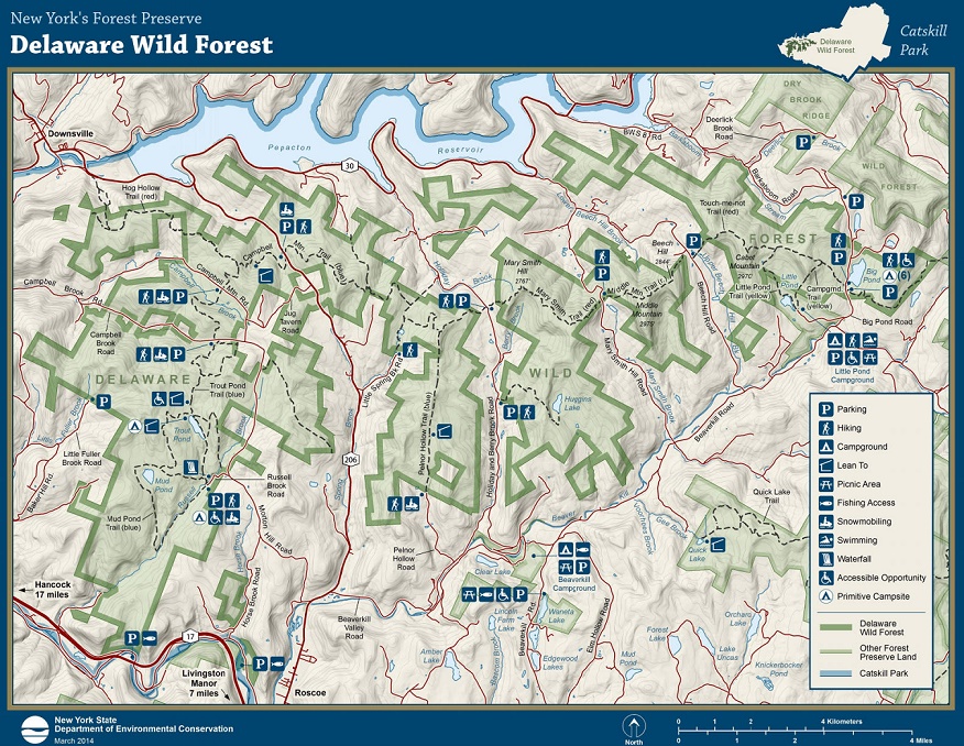
Delaware
Wild Forest
![]()
| CNY Hiking HOME PAGE | Catskill Park | Catskill 3500 | FLT Eastern/Catskill Section | Catskill 67 |
|
Hiking in Catskill Park Delaware Wild Forest
|

The 27,800 acre Delaware Wild Forest is located in the western Catskills. The popular Finger Lakes Trail travels through this wild forest, which features over 35 miles of hiking trails and over 20 miles of snowmobile trails. These trails are not as used as much as other trails in the Catskills and you may find the trails not as well maintained. There are four lean to shelters located in the wild forest for those looking for a backpacking camping experience.
The most popular destinations in the Delaware Wild Forest include Big Pond, Beaverkill Vista on Cabot Mountain, Trout Pond, Russell Brook Falls, Split Rock Lookout and Huggins Lake. Look below for information on the trails in this forest.
Hiking Trails in Delaware Wild Forest -
Touchmenot Trail - This red marked trail coincides with the Finger Lakes Trail as it travels from Beech Hill Road and Alder Lake. The trail passes by beautiful Big Pond and the views from the Beaverkill Vista on Cabot Mountain. The trail covers 6.7 miles and leaves Delaware Wild Forest as it heads toward Alder Lake to enter Balsam Lake Mountain Wild Forest.
Middle Mountain Trail - This red marked trail coincides with the Finger Lakes Trail as it travels 2.3 miles from Mary Smith Hill Road to Beech Hill Road.
Mary Smith Hill Trail - This red marked trail coincides with the Finger Lakes Trail as it travels 4.3 miles from the Pelnor Hollow Trail to Mary Smith Hill Road.
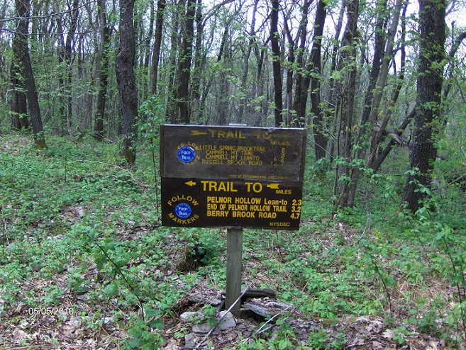
Pelnor Hollow Trail - This little used trail travels from the end of a rough dirt Pelnor Hollow Road up 1.0 miles to the Pelnor Hollow Lean To. The blue marked trail continues to ascend, reaching the junction of the Mary Smith Hill Trail at 3.2 miles. The trail now coincides with the Finger Lakes Trail. After a steep descent the trail reaches the views from Split Rock Lookout at 3.4 miles. The Pelnor Hollow Trail ends at 4.5 miles at the junction of the Campbell Mountain Trail and Little Spring Brook Trail.
Pelnor Hollow Trail at the Mary Smith Hill Trail junction
Campbell Mountain Trail - This blue marked trail coincides with the Finger Lakes Trail for most of the distance of this trail. The trail travels from Campbell Mountain Road, at 0.8 miles reach the junction of the Hog Hollow Trail. This is where the Finger Lakes Trail joins the Campbell Mountain Trail. At 1.2 miles reach a side trail on the right that travels a short distance to the Campbell Mountain Lean To. At 2.4 miles reach and cross NY 206. There is some parking available here. At 4.7 miles reach a high point on Brock Mountain. At 4.9 miles reach the junction of the Miller Hollow Trail. At 6.3 miles reach the junction of the Pelnor Hollow Trail and Little Spring Brook Trail. The Campbell Mountain Trail ends here.
Little Spring Brook Trail - This short trail travels 0.7 miles from the end of Little Spring Brook Road to the junction of the Campbell Mountain Trail and the Pelnor Hollow Trail. After 0.4 miles the trail passes a small pond. In 2011 this trail was destroyed by Tropical Storm Irene.
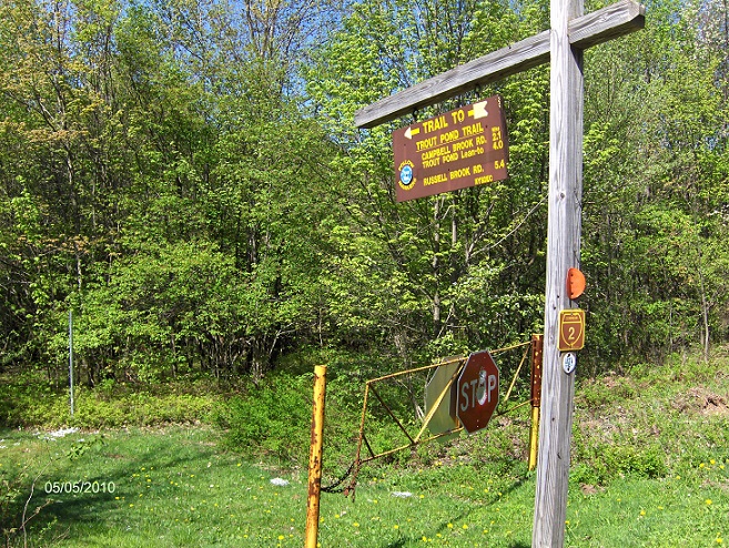
Trout Pond Trail - This blue marked trail travels 5.4 miles from Russell Brook Road to Campbell Mountain Road. The trail crosses Russell Brook on a bridge just past the trailhead. Russell Brook Falls is found just a short distance upstream. At 0.1 miles there is a trail register. At 0.9 miles the trail reaches the south shore of Trout Pond. At 1.4 miles there is a junction of side trails that lead to lean to's, one to north and the other to the west. From the pond the trail ascends over 500 feet in elevation, then descends to cross Campbell Brook at 2.9 miles.
At 3.1 miles the trail passes a gate and reaches Campbell Brook Road. The trail turns left and follows the road for just over 500 feet before turning right off the road past a DEC sign. The trail again ascends, then descends, up and down, crossing a few streams before finally reaching a gate at Campbell Mountain Road at 5.4 miles. The trail straight ahead is the start of the Campbell Mountain Trail.
Trout Pond Trail at Campbell Mountain Road
Mud Pond Trail - The blue marked Mud Pond Trail offers hikers a couple of loop options when also utilizing the Trout Pond Trail. The trail starts off the Trout Pond Trail about 0.1 miles from the main trailhead and ends on the northern shores of Trout Pond, 1.4 miles along the Trout Pond Trail (4.3 mile total loop hike). Hikers can also do a 2.3 mile loop using just Mud Pond Trails. The trail never actually makes it to Mud Pond, however after 1.9 miles there are side trail that lead to this small pond.
Huggins Lake Trail - This unmarked trail utilizes an old woods road for a pleasant 1.7 mile walk to the shore of Huggins Lake, where there is suppose to be numerous informal campsites.
Hog Hollow Trail - This orange marked snowmobile trail coincides with the Finger Lakes Trail up to the Campbell Mountain Trail. Normally this trail gets no hiking activity, however now that it is part of the FLT it does get some action.
Little Pond Trail - This yellow marked trail travels along the east shore of Little Pond and then ascends Cabot Mountain to the Touchmenot Trail. Many campers from Little Pond Campground use this trail, Touchmenot Trail and Campground Trail to create a rugged loop hike.
Campground Trail - This yellow marked trail leaves Little Pond Campground and ascends 0.8 miles to the summit of Touchmenot Mountain and 1.1 miles to the junction of the Touchmenot Trail.
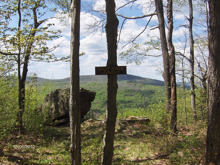
Approaching Split Rock Lookout along the Finger Lakes Trail
| CNY Hiking HOME PAGE | Catskill Forest Preserve | Catskill 3500 Club | Finger Lakes Trail Eastern/Catskill Section |