Watkins Glen
State Park
![]()
| CNY Hiking HOME PAGE | Finger Lakes Trail | NCT in Central New York | Watkins Glen State Park |
|
North Country Trail Watkins Glen State Park
|
|

This section of the North Country Trail starts just east of Sugar Hill State Forest off of Van Zandt Hollow Road. Although most of this section is in Watkins Glen State Park, the start of the section is on private property. This section of trail follows Glen Creek and also crosses Townsend Creek. The trail continues into the small city of Watkins Glen. The NCT coincides with the white blazed Finger Lakes Trail along this stretch of trail.
The section on private property is CLOSED during hunting season from Oct 1 - Jan 1. Please respect the landowner rights by staying off the trail during these dates and when on private property, stay on the trail. There is a blue blazed bypass along Van Zandt Hollow Rd, Townsend Rd and a park service road that you can follow during hunting season. It is also recommended to use the bypass during high water times due to the crossing of Townsend Creek. This creek can be dangerous and impassable when water is high. This section is one of the best sections of the North Country Trail. It is a favorite for many hikers. The trail loses 840 feet in elevation in this section.
Camping is not allowed along the trail in Watkins Glen State Park. The park campground is open from mid May to mid October. Through hikers can also find lodging/food/supplies in Watkins Glen. Toward the end of this section you will pass a Wal-Mart Super Center. Look below for a few pictures, a video, trail map and detailed description of this section of trail.
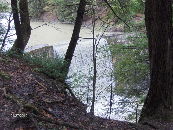
Punchbowl Dam
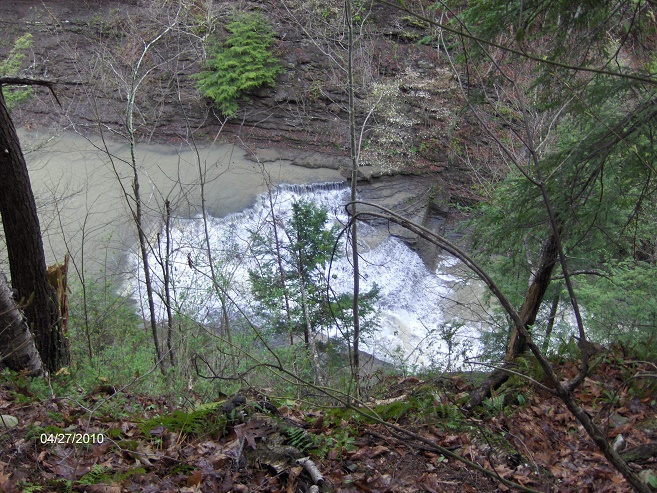
Waterfall along the trail
Mileage Elevation Trail Description 0.0 1295 feet Trail turns off VanZandt Hollow Road. NOTE: This section of trail is CLOSED for hunting from Oct 1 - Jan 1 up to the state park boundary. See above for high water warning.
0.1 1284 feet Cross pipeline. This area had major construction in 2008 on the pipeline.
0.6 1185 feet Enter Watkins Glen State Park.
1.1 1087 feet Cross Townsend Creek. This area is often flooded & washed out.
1.5 1123 feet Cross park access road to Hidden Valley Camp. Blue blazed bypass comes in from the right.
2.5 1035 feet Turn right onto Whites Hollow Road. Parking.
2.6 1070 feet Trail turns left on old park road. Soon pass gate. Parking.
2.9 1030 feet Trail leaves old road on left. Views of gorge below begins. Pass under power lines.
3.0 1011 feet Waterfall below.
3.2 967 feet Trail travels by an old picnic shelter with a grand fireplace. Punch Bowl Lake is on your left.
3.4 919 feet Dam of Punch Bowl Lake. Waterfall.
3.8 1006 feet Pass under railroad tracks. Stay off railroad.
4.2 914 feet Access to the park's Gorge Trail is on your left. Soon pass an old lean to (no camping) on your right.
4.5 866 feet Side trail on right leads to South Rim Picnic Area & park campground. Descend steeply.
4.6 742 feet Passing through an old picnic area.
4.7 699 feet Stone display on left. Junction of park trails. Suspension bridge to left. South Pavilion is to your right. Pond.
5.0 524 feet Turn left on NY 329.
5.1 460 feet Turn left on NY 14. On your left is the park main entrance. Turn right on 10th St.
5.4 459 feet Turn left on Magee Street.
5.8 449 feet Turn right on NY 414.
5.9 449 feet Walmart Super Center & fast food on your right.
6.0 443 feet Cross Barge Canal bridge, then trail turns left off road and enter Clute Park.
6.4 448 feet Trail leaves park and reaches NY 414. End of this section.
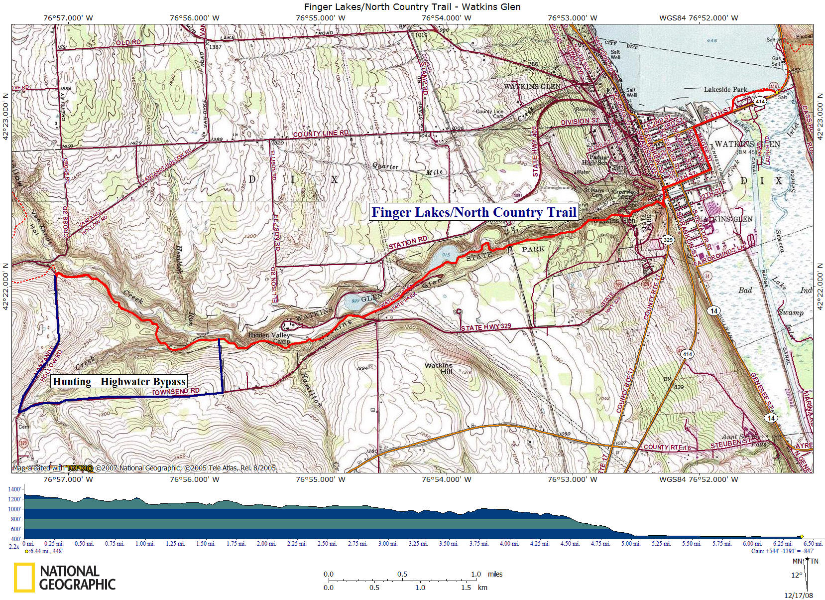
click on the map above for a larger map of this section of the FLT/NCT
| CNY Hiking HOME PAGE | Finger Lakes Trail | FLT - Central Section |
| Watkins Glen State Park | North Country Trail in NY | North Country Trail in CNY |