Hammond Hill &
Robinson Hollow
State Forests
![]()
| CNY Hiking HOME PAGE | FLT Central Section | NCT in Central New York | Hiking in Tompkins County |
|
North Country
Trail Hammond Hill & Robinson Hollow State Forests
|
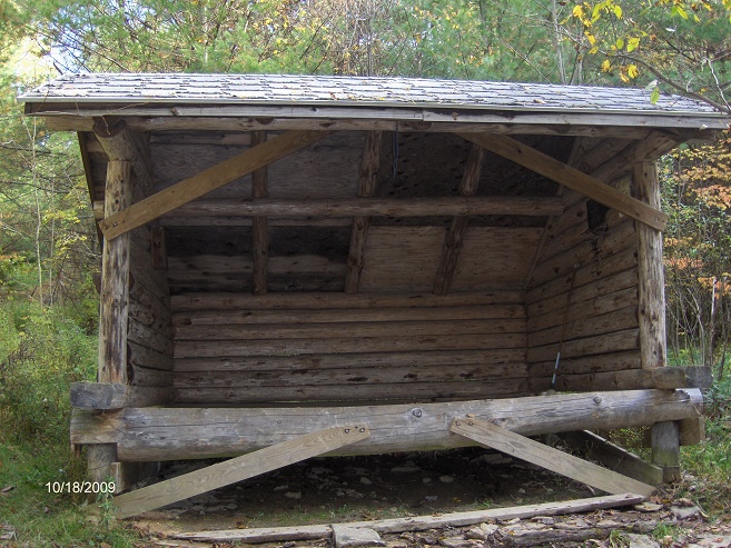
This 7.1 mile section of the North Country Trail features Robinson Hollow State Forest and Hammond Hill State Forest. The Kimme Lean To is located in Robinson Hollow State Forest. This stretch of the NCT coincides with the white blazed Finger Lakes Trail.
The trail crosses Owego Creek, enters Tioga County and follows NY 79 for a short time east of Caroline then turns left on Robinson Hollow Rd. In 0.3 mile the trail turns left off the road and enters Robinson Hollow State Forest. The section of trail on this page starts here. The trail steeply follows an old DEC logging road, then follows a narrow woods road. After descending, you will pass a blue blazed side trail (after crossing a small creek) that leads to Kimmie Lean-To. Look below for a video of this part of the hike.
The trail leaves Tioga County and enters Tompkins County, then crosses a natural gas pipeline. You are now in Hammond Hill State Forest. The trail crosses Harford Slaterville Road and will soon ascend toward a microwave tower. There is a trail register near the tower along the trail. There are no views here. There was a reroute here in July 2009 that took the trail off a muddy area on private property to Hammond Hill State Forest Trail Red 2. Look below for a video of this rerouted new section of trail.
The trail follows some of the DEC trails in Hammond Hill State Forest. There are many trails in this state forest and is a popular location for hiking. The trail veers away from one of the state forest trails and descends toward Star Stanton Road. Part of this road is abandoned, but soon you reach the drivable section. Views ahead of you begin as you continue to descend toward NY 38 and the end of this section.
Look below for pictures, a couple of videos, a map and a detailed trail description of this section of the North Country Trail.
DIRECTIONS - From Ithaca, NY 79 EAST, then left on Robinson Hollow Rd. You will see the Finger Lakes Trail sign and white blazes on left just past where the road bends to the right. Limited parking on side of the road.
Kimmie Lean To
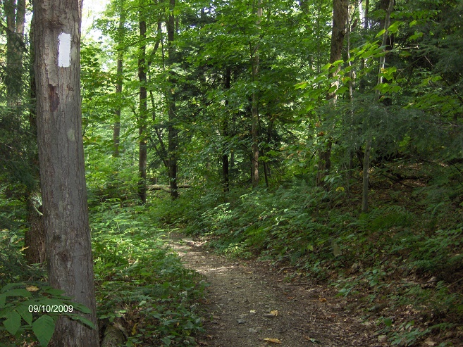
Trail in Hammond Hill State Forest
Mile Elevation Description 0.0 1290 feet NCT leaves Robinson Hollow Rd following an old DEC logging Road. Entering Robinson Hollow State Forest. Follow the white blazes. Limited parking here.
0.5 1680 feet Trail levels off and then descends.
0.7 1652 feet Steeper descent.
0.8 1436 feet Cross small stream. Blue blazed trail on right leads 0.1 mile to Kimmie Lean-To. Begin to ascend.
2.0 1846 feet Leave Robinson Hollow State Forest and enter Hammond Hill State Forest. Leave Tioga County and enter Tompkins County.
2.8 1915 feet Cross natural gas pipeline
2.9 1956 feet Begin descent toward Harford-Slaterville Rd.
3.5 1622 feet Cross Harford-Slaterville Road, turn left and up hill. Limited parking.
4.9 2011 feet Trail passes near microwave tower. Trail register.
5.0 1981 feet Trail veers left onto state forest DEC RED 2 TRAIL.
5.2 1834 feet Trail levels off.
5.35 1844 feet Now following state forest DEC YELLOW 4 TRAIL.
5.8 1842 feet Veer right off state forest trail. Follow white blazes.
6.1 1825 feet Reach the undriveable section of Star Stanton Rd, turn right and follow dirt road down hill. Views.
7.1 1284 feet NY 38. Trail turns right along NY 38 then left down Purvis Rd to Lehigh Valley Railroad and the Jim Schug Trail. For a continuation see Kennedy State Forest.

| CNY Hiking HOME PAGE | Hammond Hill State Forest | North Country Trail in CNY |
| Finger Lakes Trail | Finger Lakes Trail Central Section | Tuller Hill State Forest |