| CNY Hiking HOME PAGE | Morgan Hill State Forest | NCT in Morgan Hill State Forest | Hiking in Onondaga County |
|
Hiking in Onondaga County Morgan Hill State Forest Fellows Hill Loop Trail
|
Fellows Hill, at 2019 feet, is the second highest point in Onondaga County. This 3.5 mile hike in Morgan Hill State Forest features the summit of the Fellows Hill, waterfalls and cascades as well as Spruce Pond. The USGS marker on the summit of Fellows Hill says "Fabius" and you may notice the same name on the map below. Between 2009-2011 there was a significant logging operation in Morgan Hill State Forest, including in this area.
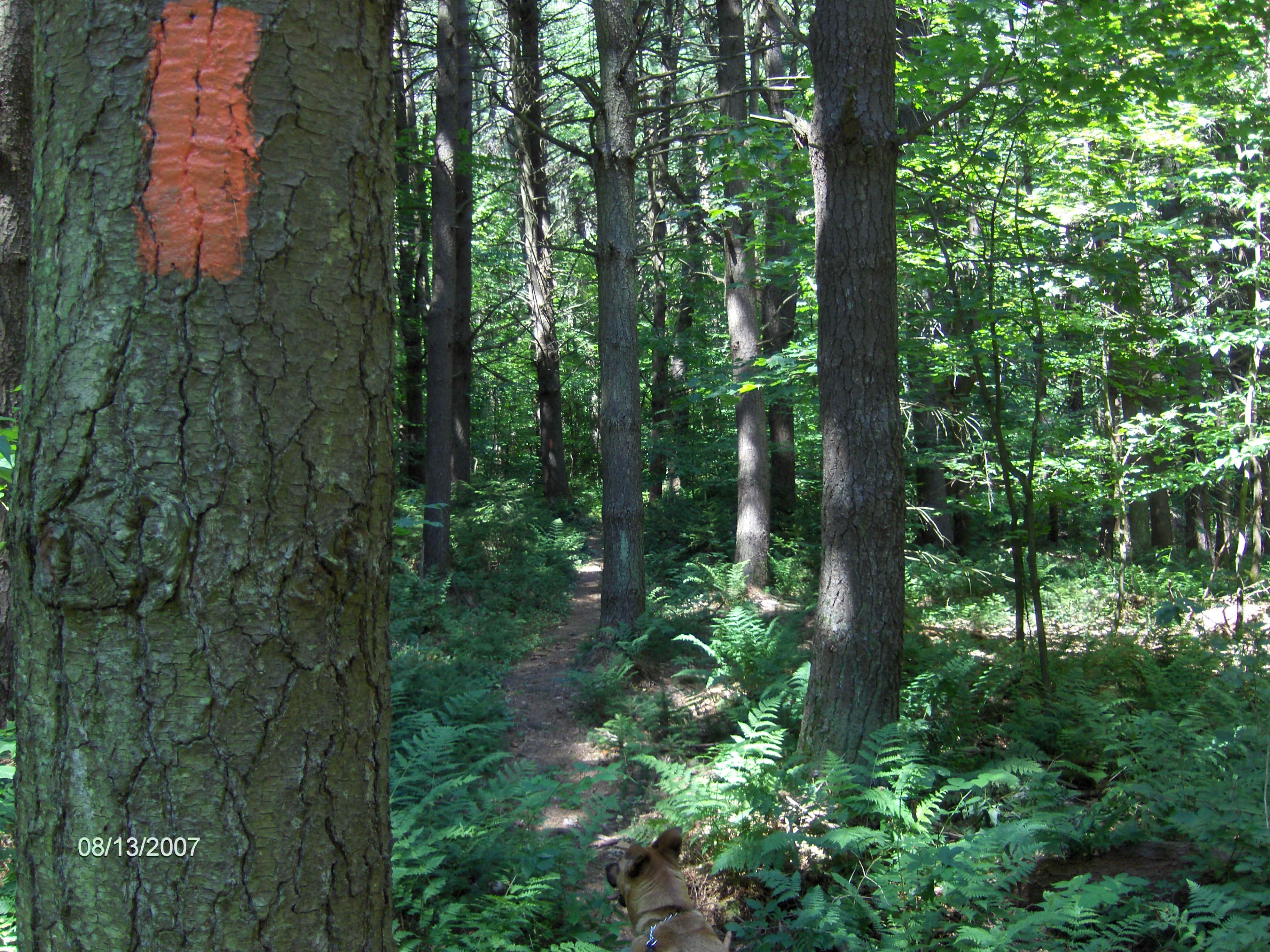
You'll notice the clear cut sections while hiking along the trail, including crossing one of the clear cuts. There was a significant trail reroute due to the logging. The Fellows Hill Loop Trail was at one time the Onondaga Trail and is currently part of the 900+ mile Finger Lakes Trail System. You will be following orange blazes for most of this hike. The Onondaga Trail was rerouted to carry the North Country National Scenic Trail through Morgan Hill State Forest. You'll notice the blue blazes of the North Country Trail as you hike near Spruce Pond, but for the most part you'll follow the orange blazes for the Fellows Hill Loop Trail. This loop is a popular hike in the forest.
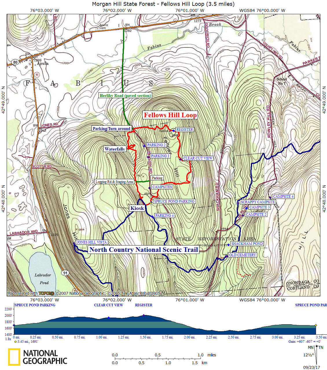
Start this hike from the Spruce Pond parking area. There are four other parking areas along Herlihy Road from where you could start your hike if you wish, including a paved parking area where the pavement ends. Park here if you don't want to drive on the seasonal dirt road to Spruce Pond. The dirt road isn't that rough, but it's recommended that you follow the 25 MPH speed limit. There is a parking area at Spruce Pond for about 8 cars. This moderate 3.5 mile loop hike has an overall elevation gain of 607 feet .
Below find directions to the trailhead, some info on this hike, pictures, a video, a map and a detailed description of the hike.
Directions: From Lafayette, US 20 East, take a right on Apulia Rd. Turn left on NY 80 East, then about a mile after NY 91 JCT, turn right on Herlihy Rd. After the pavement ends, drive another 1 mile on the seasonal dirt road to the Spruce Pond trailhead parking area. Just before the trailhead the road has a Y (keep right). There is alternate parking at the snow plow turn around where the pavement ends. The GPS coordinates are N42 47.961 W76 01.534 for the parking area at Spruce Pond and N42 48.700 W76 01.798 for the alternate parking at the snow plow turn around where the pavement ends.
This hike begins at the small parking area on Spruce Pond. Sometimes this parking area does get filled up on summer weekends, however there are other parking areas along the dirt road (see map below) to choose from. Walk from the parking area follow the orange blazes as you walk on the dirt road you just drove down on. This is one of our favorite hikes and we've done the Fellow Hill Loop numerous times over the years.
As you walk briefly on the dirt road, you'll notice a few campsites on your left. This is the Spruce Pond camping area and you soon will see a sign stating "Camping By Permit Only". Permits are free and can be obtained through the NY DEC. Look for the double blaze on the tree with one of the "Camping By Permit Only" signs and turn right into the woods here. This turn can easily be missed.
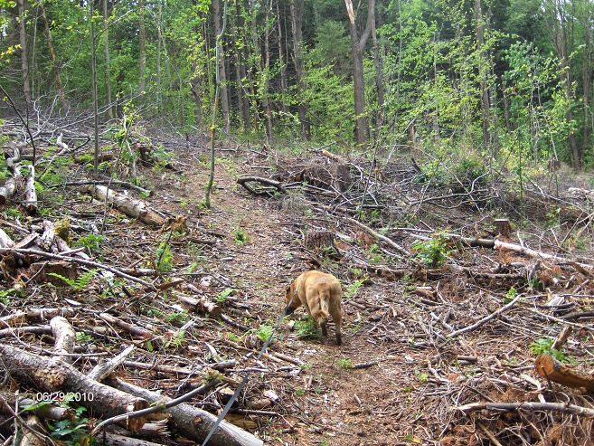
You're only in the woods for a short time before reaching seasonal dirt Herlihy Road aka Onondaga One Road. Turn right and follow this dirt road for a short time before turning left back into the woods where you see the yellow Onondaga Trail sign or just follow the orange blazes. The trail climbs gently and soon you'll cross a logging road, which is also used as a snow mobile trail in the winter. Following the orange blazes, the trail come to and travels across a clear cut from 2009. There have been numerous clear cuts in Morgan Hill State Forest over the past few years. This is the first of a few that the trail will travel close by, however the only clear cut the trail actually crosses.
The trail re-enters the woods and runs along the edge of another clear cut. Soon you may notice an out of place yellow Onondaga Trail sign on a tree. This marks the junction of the old trail and you'll turn left here. With all the logging that has been taking place, you've been hiking on a relocated section of trail and now have met up with the old trail. When you turn left here, you are on the old trail.
The trail soon turns or veers left to follow an old woods road that is now a grassy lane. You'll notice the "posted" signs. We believe this short section is on private property. The trail will turn left off the old road and re-enter Morgan Hill State Forest. You'll have a real nice view of a clear cut before the trail goes onto another old woods road. When the trail veers left off the old road and begins to climb a little, this marks the final ascent to the summit of Fellows Hill. When you arrive at the trail register on the tree, you are at the summit. The USGS summit marker is a few feet to the left of the register, off the trail.
Now begins a steady descent off the hill toward Herlihy Road. This descent has been made better over the years with improvements on the trail with the use of switchbacks and relocating the trail away from an old washed out logging road. When you finally reach Herlihy Road cross the ditch on a nice footbridge and turn left, following the unpaved section of Herlihy Road for just a short bit before turning right off the road back into the woods at a Finger Lakes Trail yellow sign.
You are now hiking on a new stretch of the loop trail that was opened in September 2013. This stretch of the trail features some small waterfalls and cascades from the numerous tributaries of Fabius Brook that the trail follows. Eventually the trail will reach an open area. This is actually what is left from a logging operation from 2010-2011. This area was a staging area. You may notice the logging road coming into the open area from the left (east). This logging road leads 0.15 miles toward Herlihy Road and a parking area. This could be another access point for this trail.
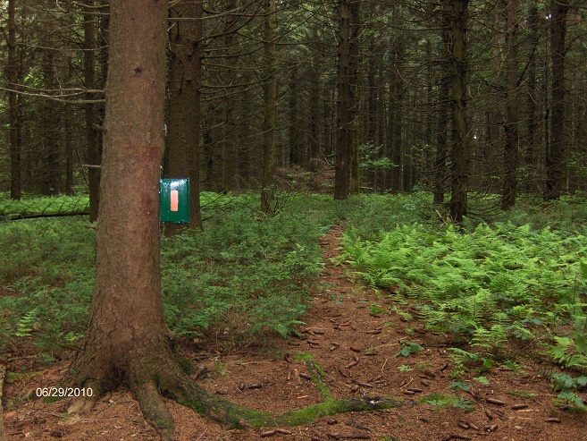
After crossing the open area the trail looks like it'll follow the well defined logging road, however it turns left off the logging road. This could be easily missed if your not looking for it. Now your heading toward Spruce Pond. None of the streams that you had been following are from Spruce Pond. When you reach the Spruce Pond area, you'll start to notice blue blazes. This is the North Country Trail and you'll follow it to the North Country Trail Kiosk, where you turn left and head back toward the Spruce Pond Parking Area. This is the end of the Fellows Hill Loop Trail.
Guide to the Hiking Trails at Morgan Hill State Forest
includes Labrador Hollow Unique Area
**ONLY $5**
Created by CNY Hiking, this guide comes to you as a pdf file that you can either print out or send it to your smart phone or Kindle. You'll have maps & info on hikes at Morgan Hill State Forest at your finger tips. Use the Buy Now button below and we'll send you the pdf file via email usually within 24 hours of payment.
Orange blazed Fellows Hill Loop Trail
Crossing a clear cut area along the trail in June 2010
Trail register located near the USGS summit marker
Mile Elevation Fellows Hill Loop Trail Detailed Description 0.0 1691 feet Spruce Pond parking area. Turn left and follow seasonal dirt road briefly, then turn right into woods. Follow the orange blazes. GPS N42 48.700 W76 01.798
0.1 1713 feet Reach Onondaga One Road. Turn right, then a quick left following orange blazes back into forest. Begin to ascend.
0.45 1877 feet Cross logging road, which is also a snow mobile trail.
0.5 1917 feet Enter and cross an area that was clear cut.
0.65 1937 feet Reach yellow Onondaga Trail sign and old trail junction. Turn left and follow orange blazes.
0.8 1939 feet Trail veers left on old woods road which is a grassy lane. Hiking on PRIVATE PROPERTY for brief time.
0.95 1886 feet Trail turns left off old woods road and re-enters Morgan Hill State Forest.
1.05 1927 feet Trail passes the edge of a large clear cut area.
1.3 1958 feet Trail now following an old woods road.
1.4 1962 feet Trail turns left off old woods road.
1.5 2019 feet Tree covered summit of Fellows Hill. USGS marker to the right. Trail register. Begin steady descent.
2.1 1576 feet Reach Herlihy Road at snowplow turnaround. Parking (May-Nov). Turn left and follow dirt road briefly then right off road.
2.4 1499 feet The trail overlooks a series of small waterfalls before turning left. 2.5 1536 feet The trail crosses stream and then turns right, following stream back toward falls. 2.6 1501 feet Reach top of the cascades. Look for some potholers. Turn left and follow old logging road. Ascend. Pass more small falls. 3.05 1715 feet Arrive at a clearing, which is an old staging area for a former logging operation. Old logging road on left goes 0.15 miles to seasonal dirt Herlihy Road (w/parking area). Continue straight and then veer left following orange blazes while old logging road goes right. Easy to miss turn. 3.25 1689 feet Junction of the blue blazed North Country Trail next to Spruce Pond. Continue straight following the blue blazes. 3.35 1689 feet NCT Kiosk. Turn left and cross the earthen dam of Spruce Pond to parking area. 3.45 1691 feet Spruce Pond parking area and end of this loop hike.
| CNY Hiking HOME PAGE | Morgan Hill State Forest | North Country Trail in Morgan Hill State Forest |