Best of the North Country Trail in New York
The Old
Quarry
![]()
| Best of the NCT in New York | Link Trail | Link Trail Perryville Section | NCT in Central New York | CNY Hiking HOME PAGE |
|
Hiking in Madison County Best of the North Country Trail in New York The Old Quarry
|
This three mile one way hike along the North Country National Scenic Trail follows the rail bed of the old Lehigh Valley Railroad. This hike features views from along the trail including a sweeping view that includes Oneida Lake and spans all the way toward Lake Ontario from in front of an old stone railroad building.
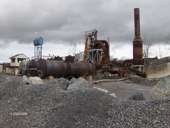
You'll find remnants of the old railroad almost every step of the way. You'll walk in front yards, back yards and even side yards of private property. You'll pass through a cow pasture. You'll see an old RR crossing sign near a driveway. For a grand finale you'll pass by an old quarry with all the old buildings and equipment still present. Remember to stay on the trail as the old quarry is on private property.
This six mile overall hike is rated easy to moderate and can be enjoyed by most everyone. Remember to stay on the trail for the whole hike, as the trail is surrounded by private property. If your hiking with your dog, please have them on a leash. When you hike this section of the NCT, you'll see why we've included it as one of the best of the North Country Trail in New York.
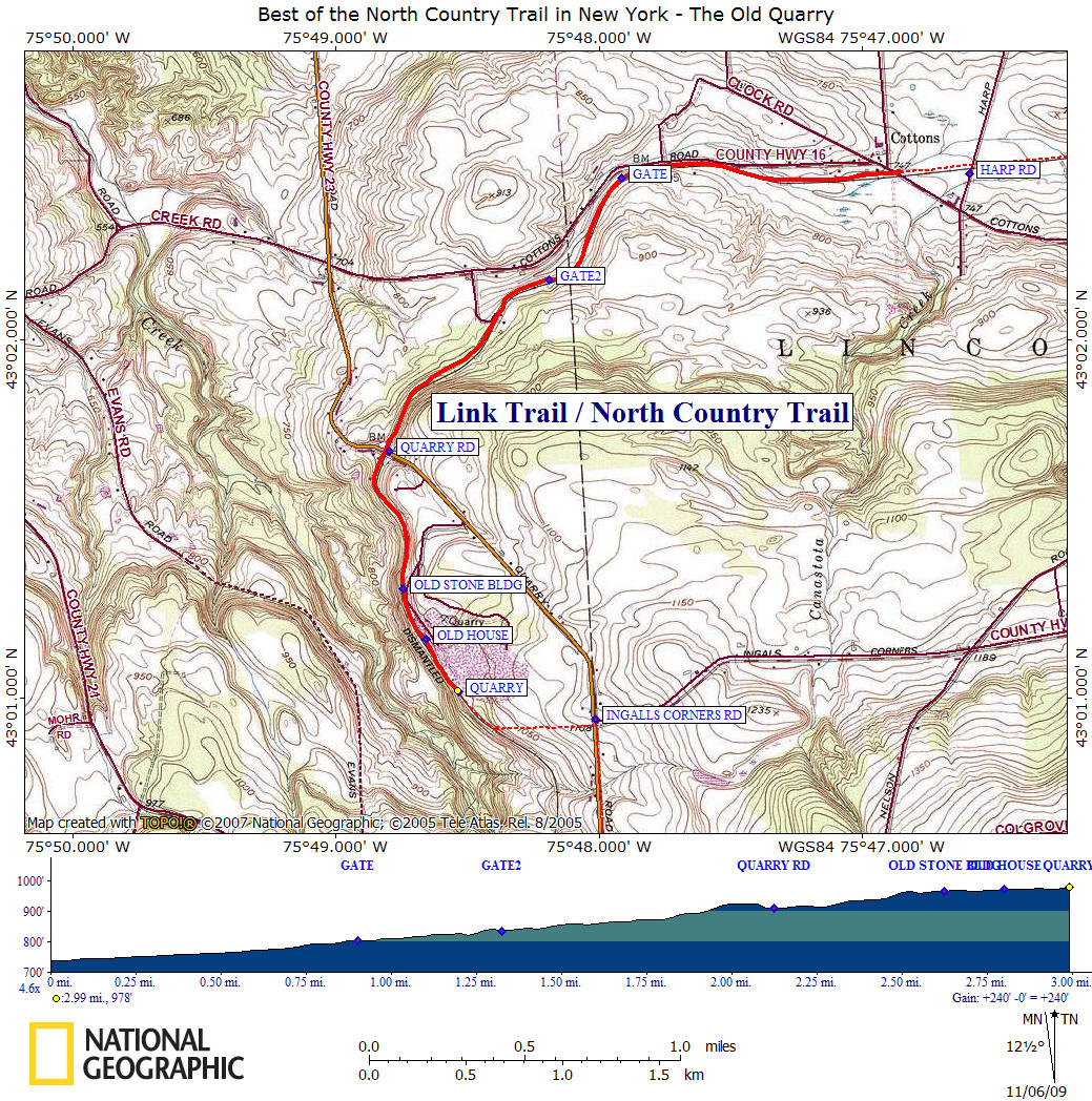
Start this hike at the small parking area off Cottons Road, west of Harp Road at "Cottons Crossing". Cross the road and follow a farm road very briefly before the trail veers right off the dirt road. Your following the blue blazes of the North Country Trail as well as the yellow blazes of the Link Trail. The 40+ mile Link Trail coincides with the NCT for this hike.
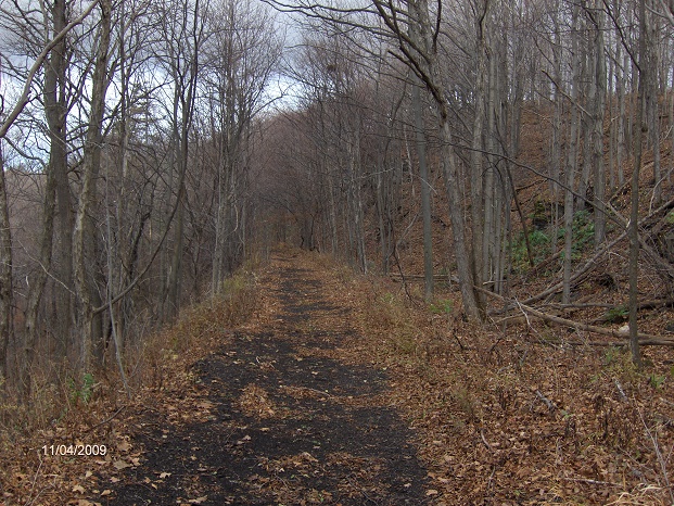
As you first walk along the old railroad bed, it doesn't look like your on a railroad bed. The vegetation was overgrown so much that the trail had to be cut through. If you look hard enough, you'll see the moss covered old wooden railroad ties tossed along the side of the bed. You'll pass close to a few backyards before crossing a private drive, then a log bridge over a small stream.
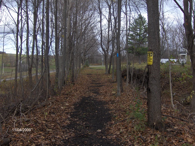
The next driveway you cross after 0.65 miles of hiking, the trail now crosses along the front of two yards before going back into the woods for a short time, only to enter a back yard of private property. Now you'll enter a cow pasture at 0.9 miles through a gate. Be sure to latch the gate behind you. Watch out for cows and cow paddies as you walk through this section.
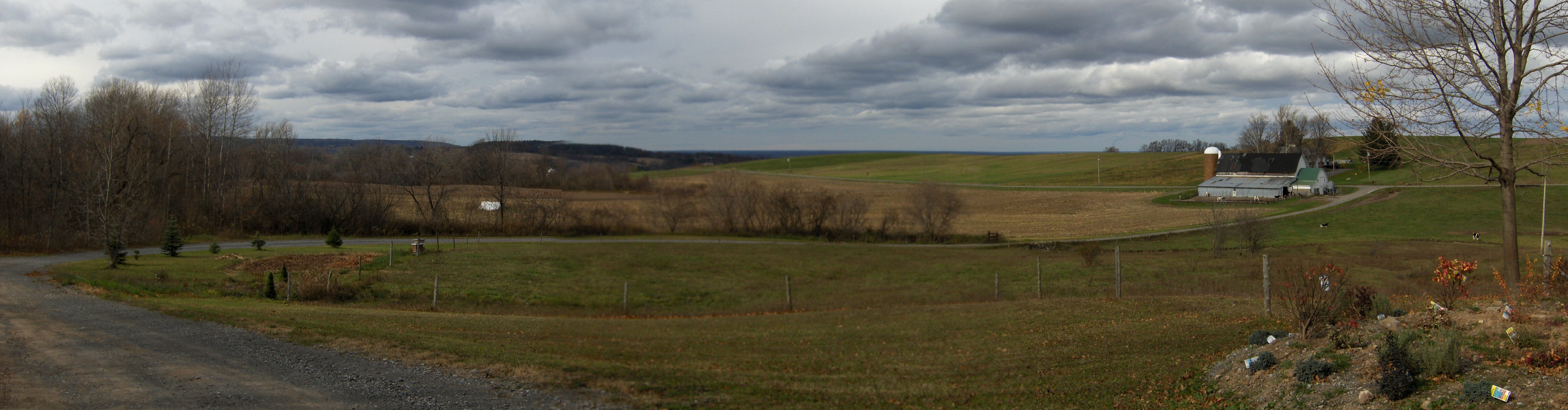
You'll leave the cow pasture (1.35 miles) through another a gate. You'll pass an area that looks like it may have been an old small quarry at one time on your left and shortly after reach an old railroad crossing sign on private property. There is a pretty nice view to your right as the trail crosses the driveway (see panorama above).
At 2.1 miles the trail passes by the side yard of private property before crossing Quarry Road. There is no parking available at this trail crossing. You'll "jog" to the left of a hedgerow as the trail passes the side yard of another private residence before passing a gate.
There is an impressive old stone building used by the railroad on your left, built along a cliff at 2.6 miles. I am unsure what the building was used for (if anyone knows, please share). To your right, in front of the building there is an opening that allows for a great panoramic view. The surprising view includes Chittenango, Oneida Lake and beyond.
You've reached the old quarry area as you pass under power lines at 2.8 miles. First you'll see an abandoned house on your right and then more old buildings on your left. The quarry is private property so enjoy the sites from the safety of the trail. You leave the quarry area at three miles. This is your turn around point.
Directions: From Canastota, take Oxbow Road and turn right on Cottons Road. Go past Nelson Road and then Harp Road. There is a small parking area on the right prior to reaching Clock Road. The GPS coordinates are N43 02.477 W75 46.864 for those who have a GPS devise. There are a few pictures, a map, detailed trail description and a video of this hike below.
Mile Elevation Hike Description (from the Cottons Crossing parking area) 0.0 738 feet Small parking area off Cottons Rd. Cross street, follow farm road briefly before veering right off farm road. Follow blue & yellow blazes. Trail is following old rail bed of Lehigh Valley Railroad.
0.65 775 feet Cross private driveway. Trail crosses a couple of private front yards.
0.8 794 feet Leaving front yards. Soon cross through a back yard.
0.9 804 feet Enter a cow pasture through a gate. Be sure to latch gate behind you.
1.35 835 feet Leave cow pasture through a gate. Be sure to latch gate behind you.
1.6 856 feet Old RR Crossing sign, cross driveway. Views.
2.15 910 feet Cross Quarry Road. Trail passes the side of private yards on both sides of road. As you cross stay to left of hedgerow.
2.6 967 feet Pass old stone building for railroad on your left. Panoramic views on your right.
2.8 972 feet Power lines, then pass old abandoned house on your right. Entering old quarry on your left.
3.0 978 feet Leaving old quarry area and the end of this hike. Simply retrace your steps to return to your vehicle.
Pictures from along the North Country Trail
North Country Trail follows the old Lehigh Valley Railroad
North Country Trail approaching a front yard
The Old Quarry along the North Country Trail
| Best of the NCT in New York | Link Trail | Link Trail Perryville Section | NCT in Central New York | CNY Hiking HOME PAGE |