
| CNY Hiking HOME PAGE | Morgan Hill State Forest | North Country Trail in CNY |
|
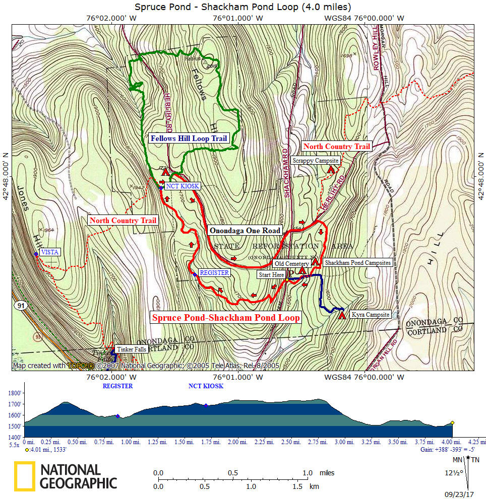
Hiking in Onondaga County Morgan Hill State Forest Spruce Pond & Shackham Pond Loop
|
DIRECTIONS: From Tully, NY 80 EAST past Apulia. Turn right on Bailey Rd, then veer right on Shackham Rd. Just past the 4 way junction of a seasonal dirt road, reach the Shackham Pond Trailhead on Shackham Rd. Park on the side of the road. Start your hike by heading up the hill. The GPS coordinates for the parking is N42 47.400 W76 00.618 for those who have a GPS devise in their vehicle.
NOTES: This hike utilizes the North Country Trail, Fellows Hill Trail and a seasonal dirt road to create a four mile mile loop in Morgan Hill State Forest. This loop hike features an old small cemetery, the two scenic ponds in Morgan Hill State Forest as well as sections of the North Country Trail completed in 2007.

Hiking along Spruce Pond
Guide to the Hiking Trails at Morgan Hill State Forest
includes Labrador Hollow Unique Area
**ONLY $5**
Created by CNY Hiking, this guide comes to you as a pdf file that you can either print out or send it to your smart phone or Kindle. You'll have maps & info on hikes at Morgan Hill State Forest at your finger tips. Use the Buy Now button below and we'll send you the pdf file via email usually within 24 hours of payment.
Mile Elevation Description 0.0 1538 feet From Shackham Road (Shackham Pond Trailhead), follow the blue blazes up the hill. There is an "Onondaga Trail" sign at this trailhead. This is the North Country National Scenic Trail that runs from North Dakota to Crown Point, NY.
0.4 1719 feet After a steady climb the trail begins to descend.
0.9 1575 feet Trail register and soon cross small stream.
1.5 1686 feet Cross dirt road.
1.7 1686 feet Reach North Country Trail Kiosk. Turn right toward Spruce Pond, now following orange blazes. Reach dirt road, turn left & follow road for 30 feet, then right into forest following orange blazes. Great spot along Spruce Pond for a break.
1.85 1710 feet Reach seasonal dirt Onondaga One Rd (aka Herlihy Rd), turn right and follow dirt road. No blazes on this stretch of the loop hike.
2.75 1745 feet Highest point on this loop hike, begin descent down dirt road.
3.15 1540 feet Reach Shackham Road. Continue straight on dirt Onondaga One Road.
3.35 1511 feet Reach North Country Trail (aka Finger Lakes Trail). Turn right into forest and follow blue blazes.
3.8 1496 feet Shackham Pond on your right. Soon pass an old 1840's cemetery.
4.0 1538 feet Reach Shackham Road and your vehicle

Shackham Pond in Morgan Hill State Forest
| CNY Hiking Home Page | Morgan Hill State Forest | North Country Trail in CNY |
| Finger Lakes Trail | North Country Trail | Pictures from Morgan Hill State Forest |