Central Adirondacks
Siamese Ponds Wilderness
Puffer Pond
![]()
| CNY Hiking HOME PAGE | Central Adirondacks | Siamese Ponds Wilderness |
|
Hiking in Adirondack Park Central Adirondacks Siamese Ponds Wilderness Puffer Pond
|
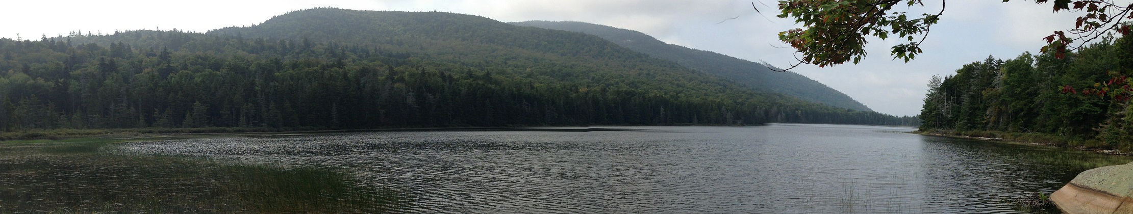
Puffer Pond is a popular hiking and backpacking destination in the Siamese Ponds Wilderness of the Adirondacks. The pond has two lean to's that are popular for backpackers looking for a scenic overnight camping adventure. There are four different routes that you can choose from, each with their own uniqueness. The most popular route is, not surprisingly the most direct route to the pond. Some choose to do a loop hike when visiting this pond.
Directions:
For the northern/western routes: From the hamlet of Indian Lake, take NY 30 south and turn left on Big Brook Road aka County Route 4. After 1.2 miles you'll cross Lake Abanakee. Bear right at a junction after 3.3 miles. Turn right at the intersection with Hutchins and Moulton Roads. At 6.1 miles pass the Kunjamuk Trail access bridge over Big Brook on your right. Reach the designated hiker parking area at the The Cabins at Chimney Mountain at 7.8 miles from NY 30. Park at the designated area. There is a small daily fee charge ($2 in 2015) for the use of this parking area by the landowner. The GPS coordinates are N43 41.283 W74 13.796 for those who have a GPS devise.
For the Eastern routes: From the hamlet of Indian Lake, take NY 28. Turn right on County Route 78 aka Thirteenth Lake Road. At the split you will either veer right for the Thirteenth Lake Trailhead on Beach Road The GPS coordinates are N43 43.120 W74 07.101 for those who have a GPS devise. Or you will veer left for the Old Farm Trailhead. The GPS coordinates are N43 42.275 W74 07.055 for the Old Farm Parking Area.
For more information on this hike we suggest purchasing the Adirondack Central Trails Map Pack
from the Adirondack Mountain Club.
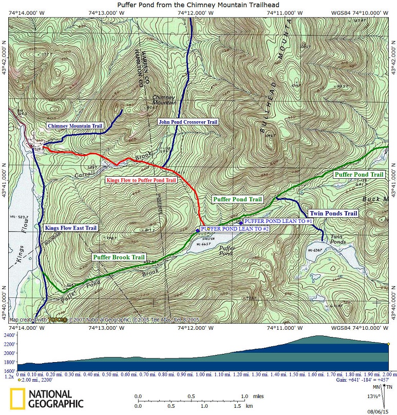
Northern Route: Puffer Pond from the Chimney Mountain Trailhead via the Kings Flow to Puffer Pond Trail
This is the most direct and obviously the most popular route for those looking to explore Puffer Pond. Starting at the Chimney Mountain Trailhead, head toward the DEC sign about 0.1 miles from the parking area. Follow the red DEC plastic markers on the Kings Flow to Puffer Pond Trail. The trail follows a wide grassy lane in the beginning, soon bearing right off the road. At 0.4 miles the trail enters Siamese Ponds Wilderness, leaving private property.
The trail crosses a small stream at 0.6 miles, then reaches Carroll Brook at 0.8 miles. Don't cross the stream here!!! The trail turns left here and follows the brook for the next 0.4 miles, before crossing the brook. After crossing the brook, the trail starts climbing. At 1.4 miles reach the junction of the blue marked John Pond Crossover Trail on your left. The blue marked trail travels 3.0 miles to John Pond. Continue to follow the red marked Kings Flow to Puffer Pond Trail.
The trail continues to climb into a col before leveling off at 1. 7 miles. Soon the trail begins to descend, sometimes steeply, as it approaches toward Puffer Pond. The trail levels as it crosses a small stream at 2.0 miles. At 2.2 miles the trail reaches the junction of the Puffer Pond Trail and the Puffer Brook Trail as well as being close by to one of the two lean to's at Puffer Pond. The second lean to is located 0.2 miles to the east (left) just off the Puffer Pond Trail. There is a side trail that leads to the second lean to. The second lean to is closer to the pond. The first lean to sits up on a hill above the pond.
After exploring the area, you can either turn around and head back the same way you came or do a loop hike by following the Puffer Brook Trail west from the first lean to you saw and then turning right on the Kings Flow East Trail back to the Chimney Mountain Trailhead. This would be approximately a 5.1 mile loop hike, not including any side trips to both lean to's on Puffer Pond. Currently the Puffer Brook Trail is NOT marked or maintained. You will find blow down and at times the trail may be tough to follow. This trail in the future will become the North Country Trail, which at that time the trail will be marked as well as maintained.
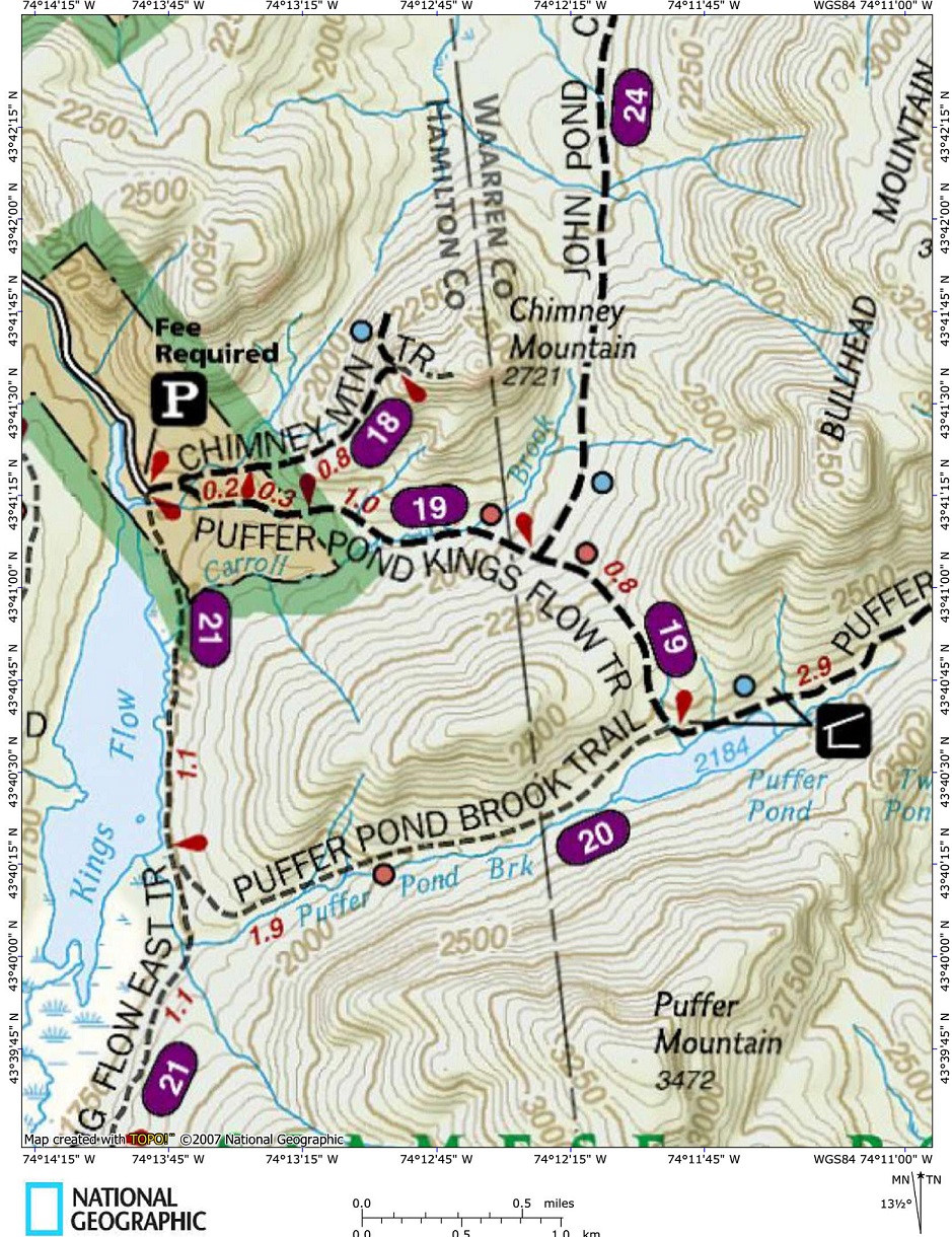
Western Route: Puffer Pond from Chimney Mountain Trailhead via Kings Flow East/Puffer Brook Trails
From the Chimney Mountain parking area, head toward the water and follow the edge of a field until you see a grassy road on your left. This is the start of the Kings Flow East Trail. At 0.4 miles you'll cross Carroll Brook. Soon Kings Flow will be seen on your right and will be close by until the junction of the Puffer Brook Trail at 1.1 miles. Turn left and start following the Puffer Brook Trail.
At 1.5 miles the trail begins to follow Puffer Brook on your right. At 2.5 miles the trail moves away from the brook. At 2.6 miles the trail reaches the edge of Puffer Pond. At 3.0 miles reach the junction of the Puffer Pond Trail and the Kings Flow to Puffer Pond Trail near Puffer Pond Lean To #2. The other lean to is 0.2 miles to the east. You could take Kings Flow to Puffer Pond Trail back to the parking area for a 5.1 mile loop or simply retrace your steps.
Currently the Puffer Brook Trail is NOT marked or maintained. You will find blow down and at times the trail may be tough to follow. This trail in the future will become the North Country Trail, which at that time the trail will be marked as well as maintained.
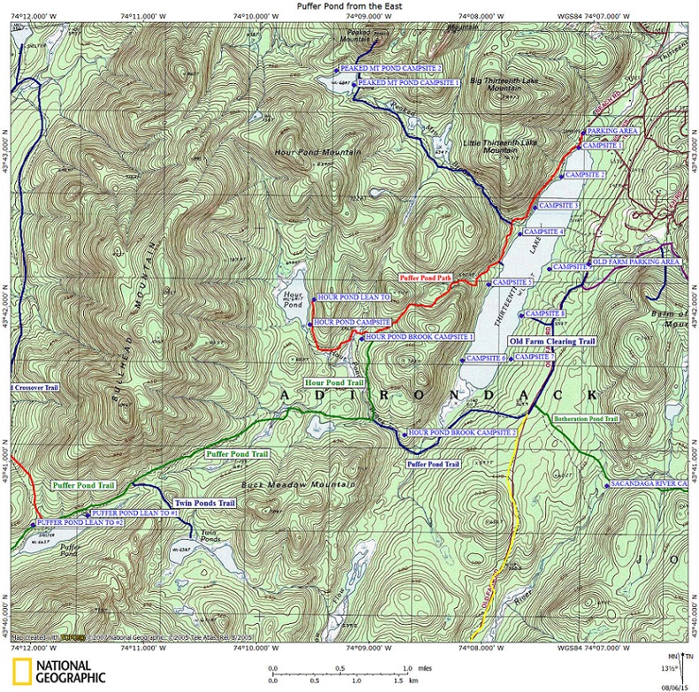
Eastern Route #1: Puffer Pond from Thirteenth Lake Trailhead
Starting from the large parking area, follow the well used accessible trail past the trail register. You are following the red marked Peaked Mountain Pond Trail. You'll soon pass by campsite #1, a handicapped accessible campsite. There are a couple of other accessible campsites in this area. The trail begins traveling along near the shore of Thirteenth Lake. At 0.4 miles a side trail on the left travels to a campsite on the lake.
At 0.7 miles there is another side trail on the left that leads to a campsite on the lake. At 0.9 miles the trail reaches the junction of the red marked Hour Pond Path. The DEC sign states it is 2.6 miles to Hour Pond. Turn left and cross the log bridge over Peaked Mountain Brook. At 1.2 miles there is a side trail that leads to the lake. Soon the trail will begin a steady climb over a ridge as it works its way from Thirteenth Lake.
At 2.1 miles the trail reaches the height of the land and begins to descend. At 2.5 miles reach the junction of the Hour Pond Trail. Turn left on the Hour Pond Trail. At 3.2 miles the trail reaches the Puffer Pond Trail. Turn right and begin to follow the blue marked Puffer Pond Trail. Soon the trail crosses Hour Pond Brook and then you'll pass through a wet area. At 4.0 miles the trail crosses a stream. At 5.3 miles pass the hard to find junction of the Twin Ponds Path on your left. After crossing another wet section, you reach Puffer Pond Lean To #1 at 5.7 miles.
The second lean to is reached at 5.9 miles near the junctions of the Puffer Brook Trail and the Kings Flow to Puffer Pond Trail. This is a long day hike and would more suitable for a one or two night backpacking trip, with a possible first night trip to Hour Pond. Look for the map at the bottom of the page featuring the trails for this hike.
Eastern Route #2: Puffer Pond from Old Farm Trailhead
From the Old Farm Parking Area, follow the old dirt road past stone barriers. You are on the Old Farm Clearing Trail, which was once open to motor vehicles up to the clearing. At 0.5 miles a side trail on the right travels down to Elizabeth Point and a campsite on Thirteenth Lake. At 1.1 miles reach Old Farm Clearing. There are numerous trails that travel out of this clearing.
On the left is the Botheration Pond Trail. Straight ahead is the blue marked East Branch Sacandaga River Trail and to the right is the blue marked Puffer Pond Trail. This clearing is also where the future North Country Trail will cross in this area. The future NCT will come from the Puffer Pond Trail and continue on the Botheration Pond Trail as it travels through this wilderness. You will be heading right onto the Puffer Pond Trail.
You will be descending almost immediately after you start your traverse on the Puffer Pond Trail. At 2.2 miles cross Buck Meadow Creek on a wooden bridge. Now the trail begins a steep climb away from the creek. At 2.4 miles there is a campsite to the right along Hour Pond Brook. At 2.6 miles you reach the junction with the Hour Pond Trail on your right.
Continue on the blue marked Puffer Brook Trail. Soon the trail crosses Hour Pond Brook and then you'll pass through a wet area. At 3.4 miles the trail crosses a stream. At 4.7 miles pass the hard to find junction of the Twin Ponds Path on your left. After crossing another wet section, you reach Puffer Pond Lean To #1 at 5.1 miles.
The second lean to is reached at 5.3 miles near the junctions of the Puffer Brook Trail and the Kings Flow to Puffer Pond Trail. This is a long day hike and would more suitable for a one or two night backpacking trip, with a possible first night trip to Hour Pond. Look for the map at the bottom of the page featuring the trails for this hike.
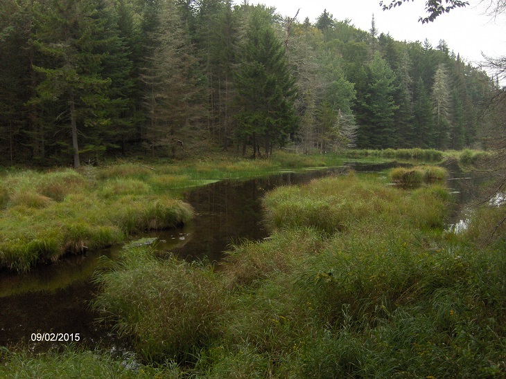
Carroll Brook
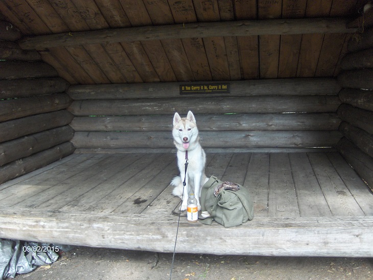
Kyra at Puffer Pond Lean To #2
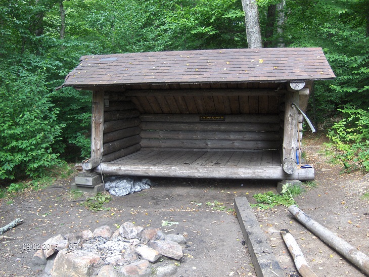
Puffer Pond Lean To #2 sits above the pond
| CNY Hiking Home Page | Siamese Ponds Wilderness |