Swift Hill State Forest
& Sixtown Creek
![]()
| CNY Hiking HOME PAGE | Finger Lakes Trail | NCT in Western New York | North Country Trail in NY |
|
North Country Trail Swift Hill State Forest & Sixtown Creek
|
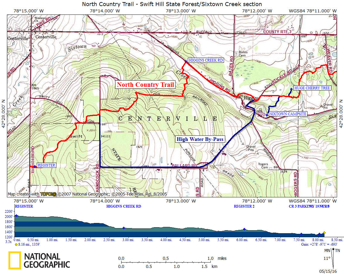
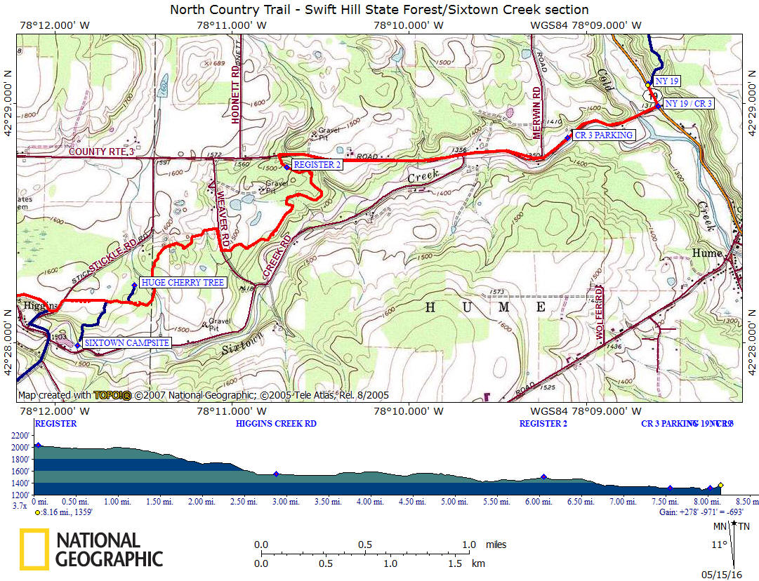
This 8.2 mile section of the North Country Trail features Swift Hill State Forest and scenic Sixtown Creek. There is a nice campsite with a picnic table just off the trail near Sixtown Creek. This stretch of the NCT coincides with the white blazed Finger Lakes Trail. There is a high water bypass when Sixtown Creek is too dangerous to cross during high water times.
This section of trail begins as the trail turns right off Rushford Road and into the 1563 acre Swift Hill State Forest. The start of this section is the highest point along the trail within this section at 2053 feet and near the end of this section will bring you to an elevation of 1288 feet along County Route 3 aka Buffalo Road. A warning for those hiking this section after heavy rain, fording Sixtown Creek can be dangerous at times. The normal water level is about six inches deep.
After 1.7 miles of hiking you will leave Swift Hill State Forest and enter private property. After descending for 0.1 mile you'll reach an old railroad grade, which you will turn right, following the old grade. This is the old Buffalo & Susquehanna Railroad and this grade was cut right into the side of the hill. Follow this old railroad bed for just under a mile before the trail turns left off the grade.
The Buffalo & Susquehanna Railroad was a regional railroad straddling the New York - Pennsylvania border. It was formed in 1885 by a Buffalo lumber and fuel dealer named Frank Goodyear. The Goodyear lumber and coal empire flourished and the railroad ran spurs and branch lines up almost every creek and valley in the area. Numerous related companies were formed, including the Goodyear Lumber Company and Lackawanna Lumber Company which by 1902 reported more than 140 miles of spurs. As coal and lumber supplies were exhausted in one area the track was pulled up and laid in another.
To get their coal and lumber to market, the Goodyears built the Buffalo & Susquehanna Railroad north from Wellsville to Buffalo. This line was completed in 1906 and linked the coal and timber lands to the ships of the Buffalo & Susquehanna Steamship Company in Buffalo. At it's height, the railroad ran 250 miles from Buffalo to Sagamore, PA and had more than 400 miles of track. Unfortunately, the boom turned quickly to a bust and the Goodyear family plus the B&S had a sudden reversal of fortune. Frank Goodyear died in 1907.
Watch the white blazes closely as the trail turns off the old grade and makes its descent toward Sixtown Creek. There is a mixture of road walks and sections off road on PRIVATE PROPERTY as the NCT makes its way toward County Route 3 aka Buffalo Road. You reach CR 3 at 6.1 miles. The rest of this section is a road walk. The section ends at 8.2 miles along NY 19 as the trail enters more PRIVATE PROPERTY. Look below for a few pictures, maps and detailed description. There have been numerous trail reroutes over the last few years on this section of trail. Be sure to follow blazes carefully.
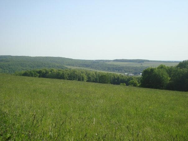
View from Swift Hill State Forest (picture by Kirk Doyle)
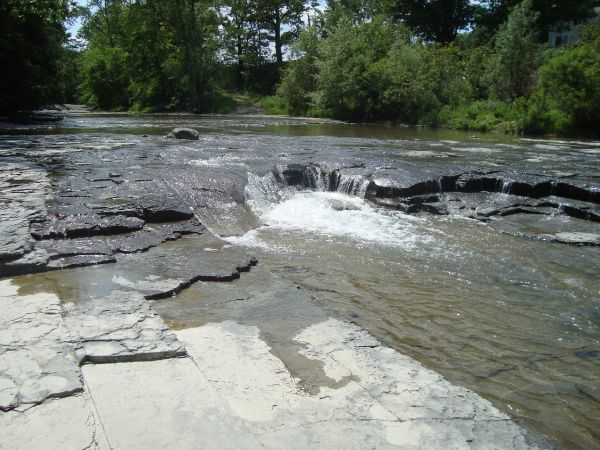
Sixtown Creek (picture by Kirk Doyle)
Mile Elevation North Country Trail Description (Follow white blazes) 0.0 2053 feet Trail enters Swift Hill State Forest off Rushford Road. After a couple of hundred feet reach a trail register. Large DEC parking area. GPS N42 27.501 W78 14.977
0.9 1982 feet Reach Swift Hill Road, follow road for 200 feet, then left off road. Shoulder parking. GPS N42 27.917 W78 14.327
1.2 1972 feet Reach Handcock Road. Junction of blue blazed High Water By-Pass. Shoulder parking. GPS N42 27.994 W78 14.068 Turn left and follow road for about 250 feet, then right off road. NOTE: If you expect high water in Sixtown Creek, turn right and follow 2.8 mile bypass.
1.7 1826 feet Leaving Swift Hill State Forest. Entering PRIVATE PROPERTY.
1.8 1769 feet Reach real old railroad grade (Buffalo & Susquehanna Railroad). Turn right & follow grade.
2.35 1716 feet Turn left off old railroad grade and descend. Watch white blazes closely.
2.7 1543 feet Cross Sixtown Creek. Then turn left and then turn right to follow farm lane. It is important that you follow farm lane.
2.9 1551 feet Reach Higgins Creek Road. Shoulder parking. GPS N42 28.509 W78 12.936 Turn right and follow road.
3.6 1529 feet Turn left onto unmarked cemetery road. Follow white blazes.
3.85 1561 feet Junction of Blue Blazed Water Bypass Trail on right. Turn left on Stickles Road.
3.95 1586 feet Right off Stickles Road, following hedgerow to the woods.
4.15 1575 feet Blue blazed trail on right travels 0.3 miles to the Sixtown Campsite. Picnic table and piped spring.
4.25 1549 feet Blue blazed trail on left travels about 400 feet to a large old cherry tree.
4.35 1528 feet Trail turns left along a property line.
4.95 1530 feet Reach Weaver Road. Turn right and follow road.
5.1 1502 feet Turn left off road.
6.05 1502 feet Trail register. Soon reach County Route 3 aka Buffalo Road. Turn right and follow this busy road.
7.55 1314 feet Shoulder parking along County Route 3. GPS N42 28.854 W78 09.106
8.05 1313 feet Reach NY 19. Turn left and follow busy NY 19. 8.2 1320 feet Right off NY 19. Limited parking. GPS N42 29.080 W78 08.648 End of this section. For a continuation see NY 19 to Whiskey Bridge.
| CNY Hiking HOME PAGE | Finger Lakes Trail | NCT in Western New York | North Country Trail in NY |