The Catskill 67
Mongaup
Mountain
![]()
| CNY Hiking HOME PAGE | Catskill 67 | Catskill Park | Catskill 3500 Club |
|
Big Indian
Wilderness The Catskill 67 Mongaup Mountain
|
In the Catskills there are thirty-five peaks that are over 3,500 feet in elevation and are noted in the Catskill 3500 Club. The Catskill 67 are the next highest peaks in the Catskills, of which, 63 are over 3,000 feet in elevation. These peaks are featured in a hiking guide, The Catskill 67
, a recommended book from the ADK Mountain Club. Mongaup Mountain at 3177 feet is the 67th highest point in the Catskills, or #32 for the Catskill 67.
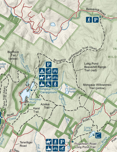
There are multiple bushwhacking routes for reaching the summit of Mongaup Mountain. The mountain is located in the Big Indian Wilderness of the Catskills, north of the popular Mongaup Pond State Campground. One route is from the Frick Pond Parking Area, GPS coordinates N41 57.047 W74 42.425 for the parking area and taking the Flynn Trail, then bushwhacking up the ridge, off the trail.
Another route is from Mongaup Pond State Campground, taking the Mongaup Pond Loop Trail to the Mongaup-Hardenburgh Trail and then bushwhacking once you reach the ridge. Where the trail turns right, you'll go left. The GPS coordinates of the campground is N41 57.419 W74 41.462. There is a day use fee for entering the campground.
Another route is bushwhacking from Shin Creek Road. You'll have to make sure that your bushwhacking route is on public land and you stay off private property. To get more detailed info on the different routes to Mongaup Mountain and other Catskill 67 hikes, we recommend purchasing the hiking guide The Catskill 67. The book gives more info on the route to this mountain. Look below for a topographic map of Mongaup Mountain to help assist in planning your hiking adventure.

| CNY Hiking HOME PAGE | Catskill Park | Catskill 67 |
