Central Adirondacks
Indian River
Tract
Hudson River, Cedar River, Clear Pond
![]()
| CNY Hiking HOME PAGE | Central Adirondacks | Hudson Gorge Primitive Area |
|
Hiking in Adirondack Park Central Adirondacks Indian River Tract Hudson River, Cedar River, Clear Pond
|
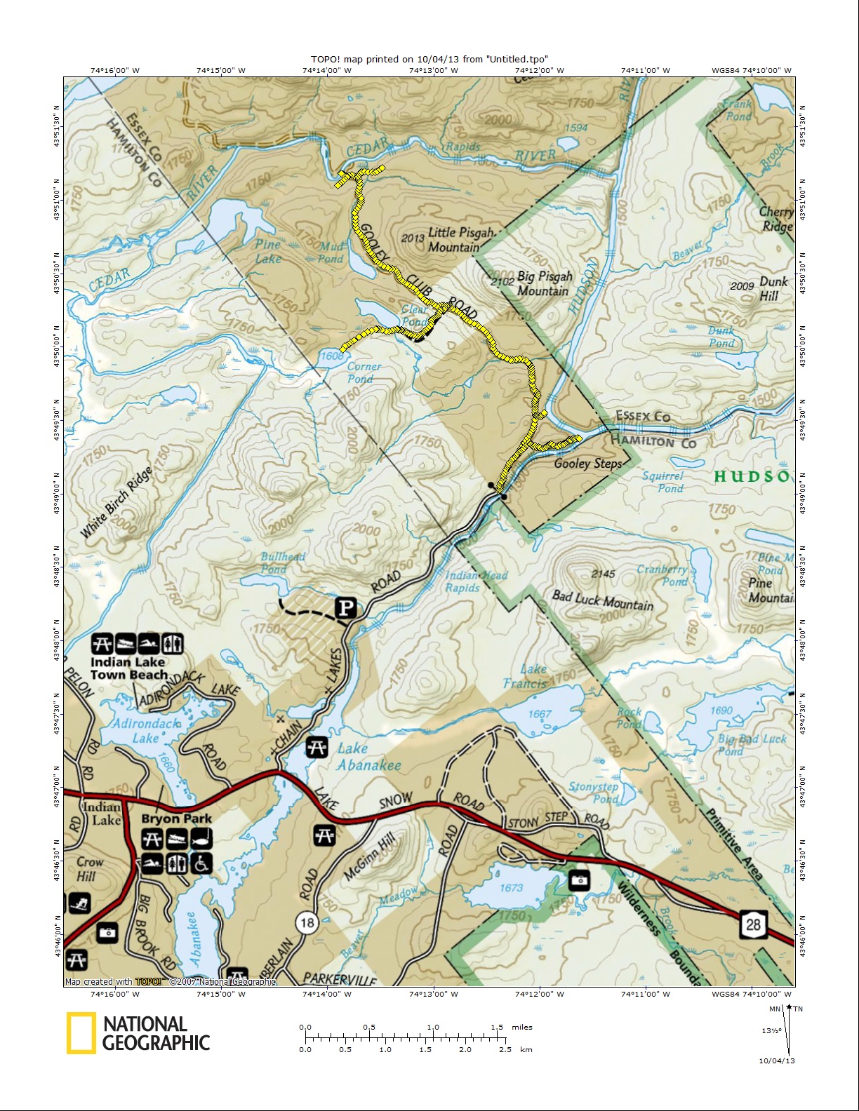
The Cedar River, Pine Lake, Mud Pond, Clear Pond, Corner Pond, Hudson River, Indian River and the surrounding lands can all be accessed from the parking area at the end of the Chain Lakes Road located off NY 28 just east of the hamlet of Indian Lake. It is a 3.5 mile hike from the parking area along a dirt road to a scenic landing on the Cedar River. The NY DEC opened this area of recently purchased land in the summer of 2013. Currently it is still awaiting final land classification (wild forest, primitive or wilderness).
The main "trail" is the old Gooley Club Road that continues past the gate at the end of Chain Lakes Road. The DEC has constructed a kiosk and trail register just past the gate. We have called this the Cedar River Trail (there is no official name yet) on the map we created after exploring this area a couple of times and GPSing the trails. You can see the trail map below of this tract plus a description of the trails. The trail names are not official, we just named them to make the trail descriptions easier.
Everything begins from the parking area at the end of Chain Lakes Road. The GPS coordinates of the parking area is N43 49.018 W74 12.385 for those who have a GPS devise. The road is paved the first mile, then is dirt the rest of the way (except for a short section near the major parking area). The dirt road is not that rough and most vehicles should be able to drive along it. There is parking for about 4-5 vehicles at this new parking area. In 2014 the DEC created a second parking area 0.8 miles further up the dirt road at the former site of the Gooley Club House.
Pass the gate and begin by checking in at the trail register. Now start hiking (or biking) along the old Gooley Club Road (Cedar River Trail). The DEC trail mileage sign says it's 3.7 miles to the Cedar River Landing, we GPS'd it at 3.5 miles. The overall elevation gain of going to the Cedar River is 279 feet for the 3.5 miles. After a brief climb the road levels off. At 0.35 miles reach a clearing on your right and fork in the road. The Cedar River Trail goes straight (veer left) while a woods road veers right. We will call this woods road the Confluence Trail.
The Confluence Trail leads 0.55 miles to the confluence of the Hudson & Indian Rivers (where the Indian River joins the Hudson River). The trail drops 116 feet in elevation as you make your way to where the Hudson & Indian Rivers meet. After 0.1 miles turn right and begin the descent toward the rivers. You will start to hear the rapids of the Indian River almost right away. Reach the river banks at 0.55 miles. This is a scenic spot worth checking out, however we read that this woods road may be "brushed" to keep people away because there are concerns about to much traffic on the fragile soil on the banks. This means moving heavy brush on the trail to make it difficult for hikers to explore the area. We hope this is inaccurate, but wanted to make everyone aware. A hike to the confluence is 0.9 miles one way from the parking area.
Indian River (on right) meets the Hudson River
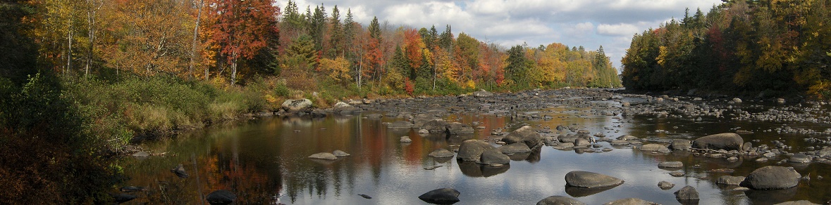
Back on the Cedar River Trail, the road descends and at 0.7 miles reaches a trail sign post with a side trail on the right. This is the Hudson River Canoe Carry. The trail leads less than 500 feet to the Hudson River dropping 45 feet in elevation to a point where the river bends. This point is where canoes can pull out before the rapids ahead. You don't need a canoe to enjoy this scenic spot (see panorama above) on the Hudson River.
The Cedar River Trail climbs again and soon you'll see the site of the former Gooley Club House come into view on your left at 0.8 miles. There is now parking available here (when the gate is open). As you pass the site there is a nice view of the Hudson River on your right. Soon the trail passes a side dirt road on the left. We are unsure where this road leads to. At 1.95 miles reach the junction of the Clear Pond Trail on your left (with signage on the right).
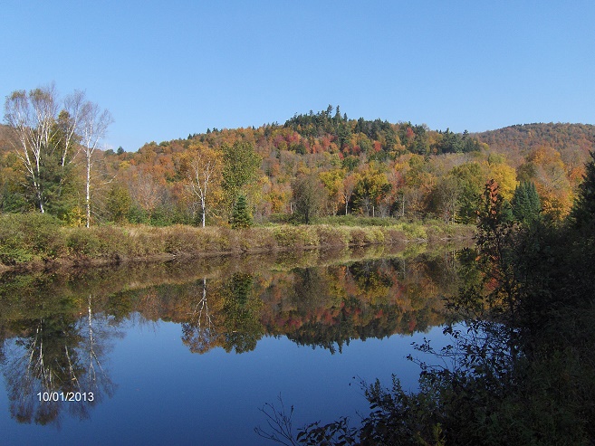
The Clear Pond Trail is marked with yellow DEC trail plastic discs. This hiking trail leads 0.55 miles to the scenic Clear Pond. The trail sign says it's 0.3 miles (it's not). The trail climbs before descending to the pond. According to some maps the trail continues on to Corner Pond, about 0.5 miles away. We did not see any trace of a trail, just a tangle of brush (although we did not look very hard).
Clear Pond
Back on the Cedar River Trail, the trail descends and you'll start to see the swampy Mud Pond through the trees at 2.6 miles. We did not see any trails that lead to the pond and really saw no reason to check out the pond. At 3.2 miles there is a quick descent and you'll pass an old steel pipe on your right. If you look to your left there seems to be an old woods road that climbs. We are unsure where this old road goes (maybe Pine Lake?).
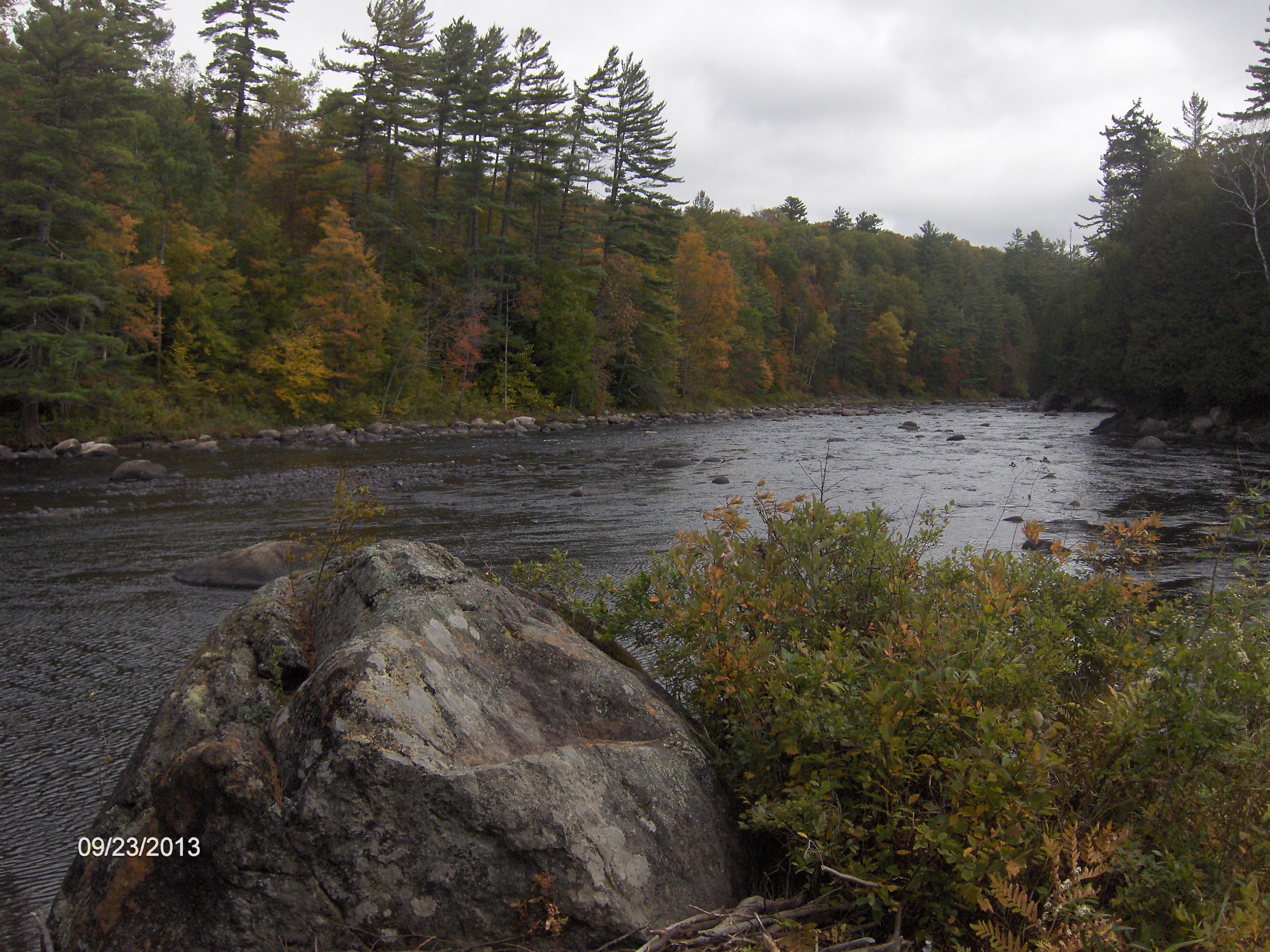
At 3.35 miles reach a fork in the road. The Cedar River Trail veers left here. We are unsure how far the right fork goes or where it ends. At 3.45 miles the Cedar River Trail turns right off the woods road. We're not sure where the woods road continues to, but wonder if this would be a good place for a trail toward Pine Lake? The trail now leads a short distance toward the bank of the Cedar River at 3.5 miles. If you weren't sure about the trail ending here, a sign has been posted saying "End of Trail". This is a very scenic spot along the Cedar River.
Cedar River

| CNYHiking HOME PAGE | Central Adirondacks | Hudson Gorge Primitive Area |