Hiking in Adirondack Park
West Central Adirondacks
Independence River
Wild Forest
![]()
| CNY Hiking HOME PAGE | West Central Adirondacks | Hiking in Lewis County | Hiking in Central New York |
|
Hiking in Lewis County Hiking in Adirondack Park West Central Adirondacks Independence River Wild Forest
|
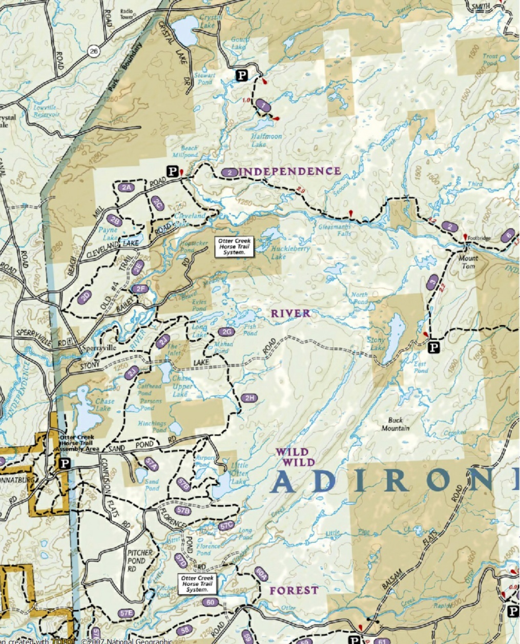
The Independence River Wild Forest covers approximately 76,000 acres inside Adirondack Park. The wild forest is located in the towns of Watson, Greig and Lyonsdale in Lewis County, as well as the town of Webb in Herkimer County. It is bounded on the west by the Adirondack Park boundary, to the south by the Ha-De-Ron-Dah Wilderness area, the Beaver River on the north and the Pigeon Lakes Wilderness to the east.
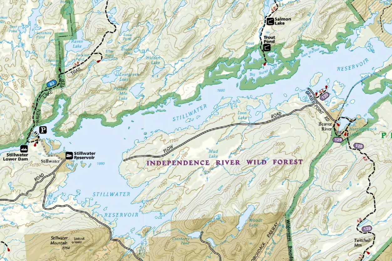
The Independence River Wild Forest is popular for many different recreational uses. The Otter Creek Horse Trail system provides over 60 miles of equestrian trails on the western boundary of the Wild Forest. While to the north, the Stillwater Reservoir provides for water related activities, camping and access to the Five Ponds Wilderness Area.
Most of the campsites on Stillwater Reservoir can only be reached by boat, except for campsite #44 (handicapped accessible) and campsite #43, which can be reached via Big Moose Road. You'll require a short walk of about 500 feet to reach the campsite from the road. There are no picnic tables or a privy at campsite #43. The panorama above was taken from the shores of Stillwater Reservoir near campsite #43.
Campsite 43 on Stillwater Reservoir
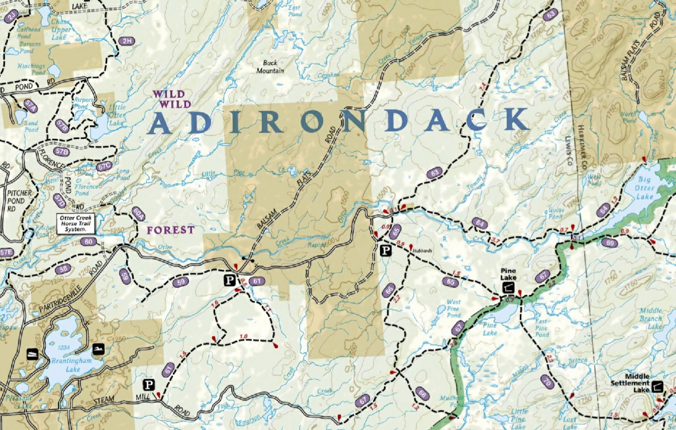
During winter months, snowmobiling is the most popular recreational pursuit in this wild forest. Corridor trails provide a connection between Brantingham and areas to the south with Stillwater, and points north. Numerous motor vehicle roads, such as the McCarthy Road, Basket Factory Road and Smith Road offer access into the interior of the wild forest. You'll find designated campsites along these roads. Look below for a map that shows some of the roadside campsites. These primitive campsites are free and first come, first serve (there are no reservations).
Although the highlight of this wild forest is the Otter Creek Horse Trail system, there are still many hiking opportunities in Independence River Wild Forest. Panther Pond Lean To and Pine Lake Lean To are two lean tos in the wild forest available for use. Below are just some hikes to try in this area. The most popular hike in Independence River Wild Forest is taking the Beach Millpond Trail to Gleasmans Falls on the Independence River, however the recently opened trail to the fire tower on Stillwater Mountain is quickly becoming very popular.
The short scenic 0.3 mile Sunday Creek Trail and an access trail that leads into the "trail-less" remote Pepperbox Wilderness are located at the Moshier Falls trailhead. Taking Stillwater Road will also take you to the McCarthy Road Trailhead for Sunday Lake. Many drive to the lake (4x4 needed for final section), try parking along McCarthy Road and take the short hike of just under a half mile to Sunday Lake. What about a one mile hike to remote Halfmoon Lake?
A trailhead near the end of Smith Road has trails that lead 0.8 miles to Bills Pond or the Panther Pond Trail that can take you one mile to Panther Pond and a lean to. There are no signs for the Bills Pond Trail. The Panther Pond Trail continues another 3.7 miles to the Independence River and Beach Millpond Trail. The 3.7 mile Centennial Ski Trail is also popular not only for x-country skiing, but for hikers as well. Trails leading toward Pine Lake, Big Otter Lake and along Otter Creek from the "Hubbards" trailhead offer numerous hiking and backpacking options. This includes a few different loop options. Kayakers will enjoy Francis Lake.
Look below for a list of destinations and a few maps of Independence River Wild Forest.
Destinations in Independence River Wild Forest
Halfmoon Lake Gleasmans Falls Panther Pond Moshier Falls Sunday Creek Big Otter Lake Sunday Lake Bills Pond Pine Lake Francis Lake Catspaw Lake Shingle Mill Falls Smith Road Number 4 Fire Tower Site Independence River Stillwater Mountain Sand Pond Little Otter Lake Payne Lake Otter Creek McCarthy Road
Panther Pond Trailhead at end of Smith Road
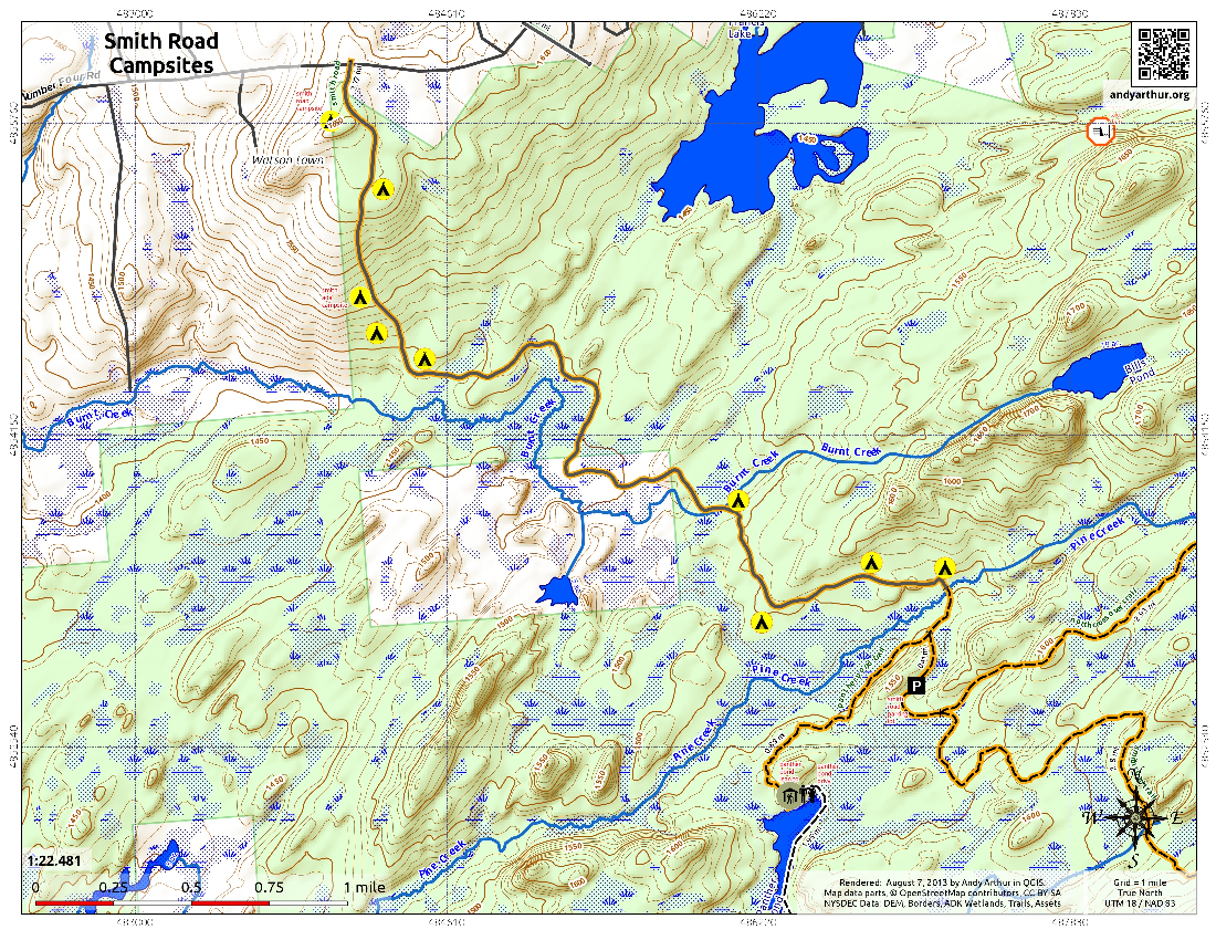
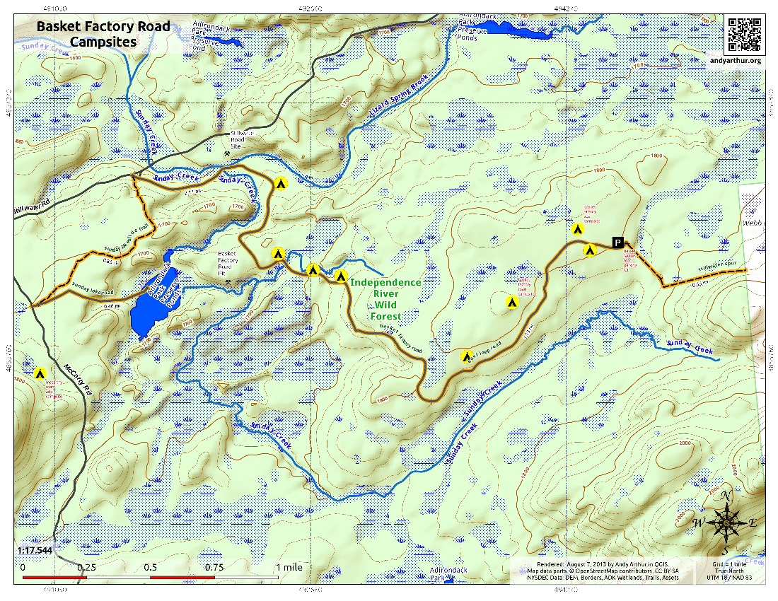
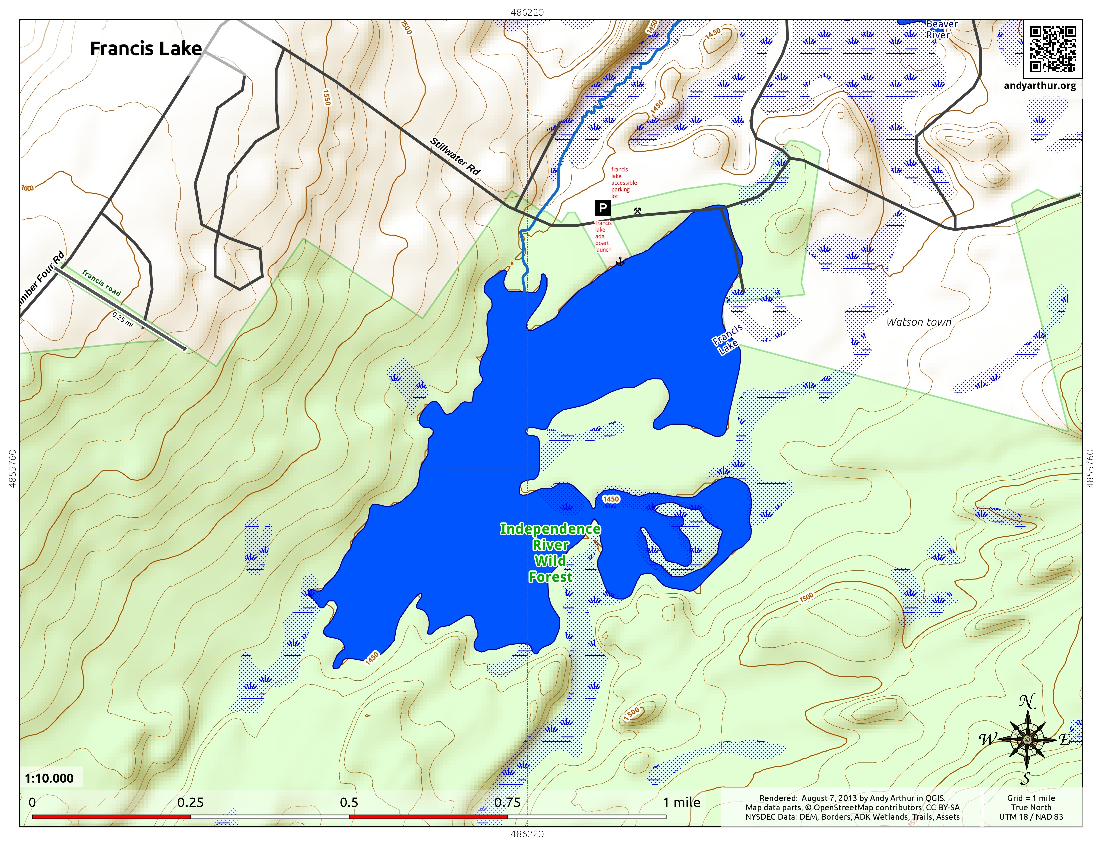
Above three maps are courtesy of Andy Arthur from AndyArthur.org
| CNY Hiking HOME PAGE | Hiking in Lewis County | West Central Adirondacks | Hiking in Central New York |