Hiking in Adirondack Park
Northwest Adirondacks
Lows Lake & Hitchins Pond Primitive Area
Lows Upper Dam &
Hitchins Pond Overlook
![]()
| CNY Hiking HOME PAGE | Lows Lake & Hitchins Pond Primitive Area | Hiking in St Lawrence County |
|
Hiking in St Lawrence County Hiking in Adirondack Park Northwest Adirondacks Lows Lake & Hitchins Pond Primitive Area Lows Upper Dam & Hitchins Pond Overlook
|
Most are unaware of the hiking opportunities in the kayaker's paradise known as the Bog River Flow Area. In fact you don't need a kayak to enjoy this remote and historical area west of Horseshoe Lake. The 2.3 mile Upper Dam Trail takes you from Sucker Brook Road to Lows Upper Dam and the ruins near the dam plus along the Bog River. A one mile trail winds to the cliffs above the dam and the spectacular views from Hitchins Pond Overlook. The view offers nothing but pristine wilderness. You will see no roads or buildings in this amazing view.
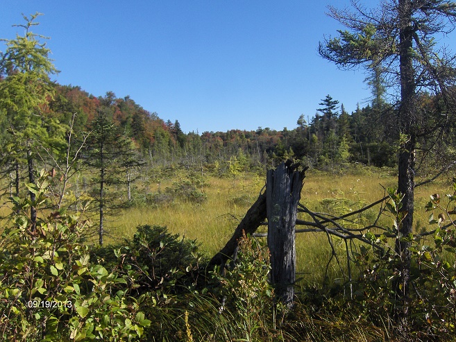
It's a long 6.6 mile round trip hike from the stop gate on Sucker Brook Road. The Upper Dam Trail is nothing more than a restricted access road to Upper Dam. We suggest taking your bike and making this a biking/hiking adventure. From the stop gate, follow the restricted access road aka Upper Dam Trail. At 0.6 miles your surrounded by an open wetland and a pretty nice view.
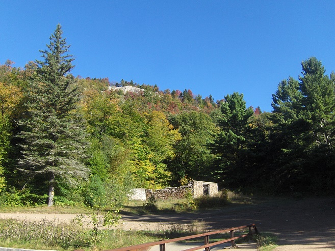
At 2.3 miles you reach another stop gate. This is the end of the Upper Dam Trail. The access road was fairly level for the 2.3 miles. In front of you is Lows Upper Dam. To the right is the Hitchins Pond Overlook Trail & register. A side trail on the left before the dam travels along the Bog River, leads to the main A.A. Low ruins and then on to a beach/picnic table on Hitchins Pond. There are two roads that leave the main area, one over the dam on the left and the other to the right.
After exploring the ruins and possibly a picnic next to Hitchins Pond, it's now time for the real treat of this hike. Head back toward the Hitchins Pond Overlook Trail and sign the trail register before starting your climb. The sign says 1.1 miles, we GPS'd it at exactly one mile, but what's 500 feet? The overall elevation gain is just over 400 feet for this simple hike. You should be able to notice that this trail was professionally built as you climb. We did notice that some folks miss the first left turn soon after the trail register as the blue markers are scarce at this quick turn away from the little stream.
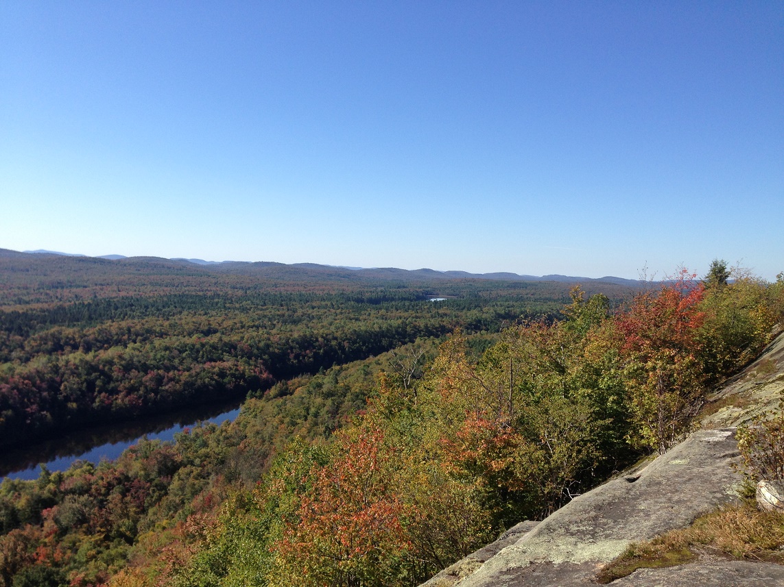
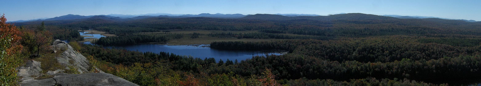
This is the only tough spot along the trail as the rest of the way the trail is easy to follow. At 0.25 miles the trail actually descends for a short bit. By 0.35 miles the climbing begins again. At 0.5 miles is the first of numerous switchbacks that help make this climb minimal. Eventually the trail makes its way to the top of the cliffs you may have noticed as you walked back from the ruins toward the Upper Dam. The view is spectacular. The Bog River is easily picked out as well as Hitchins Pond (hence the name of the trail). Coney Mountain is visible as well as the Sewards in the distance.
The cliff top is long and is the perfect place to stop, take a break and enjoy this pristine view of the Adirondacks. Look below for a few pictures and a few maps of the Upper Dam-Hitchins Pond Overlook Trail.
Directions: NY 30 south from Tupper Lake, then a right on NY 421 to Horseshoe Lake. Soon you'll cross the Bog River and the Bog River Falls. The pavement ends and turns into a seasonal dirt road. The access road to Lows Lower Dam is on the left. Continue on the seasonal dirt road to the main parking area for Horseshoe Lake, turn left on seasonal dirt Sucker Brook Road and drive over railroad tracks. Drive 0.9 miles to stop gate on left. Park without blocking gate. You can also park before crossing the RR tracks at the Horseshoe Lake Parking Area.
Along the Upper Dam Trail
Some of the A.A. Low ruins near the Lows Upper Dam and cliffs above
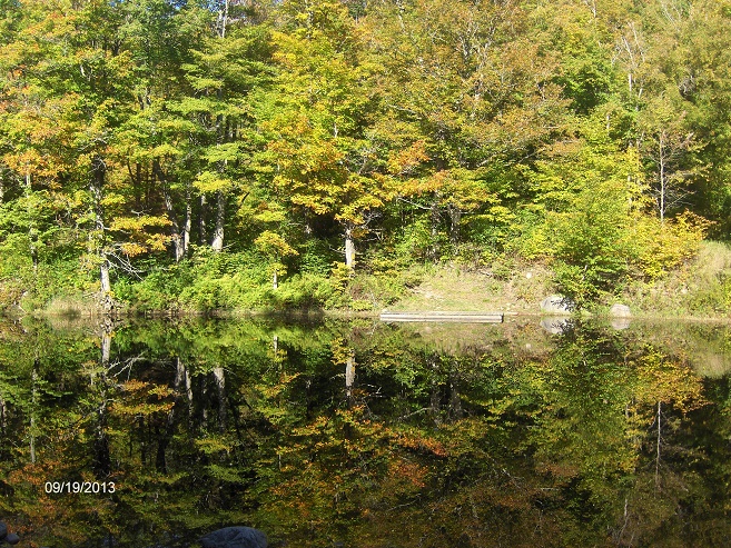
Reflections on the Bog River above Lows Upper Dam
Spectacular views await you at the Hitchins Pond Overlook
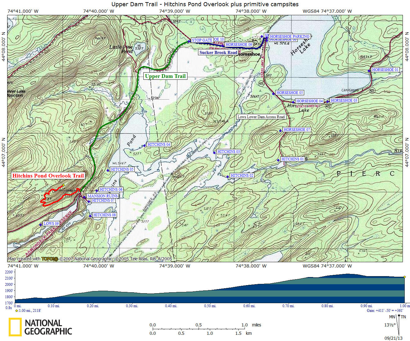
above elevation gain is only for the Hitchins Pond Overlook Trail
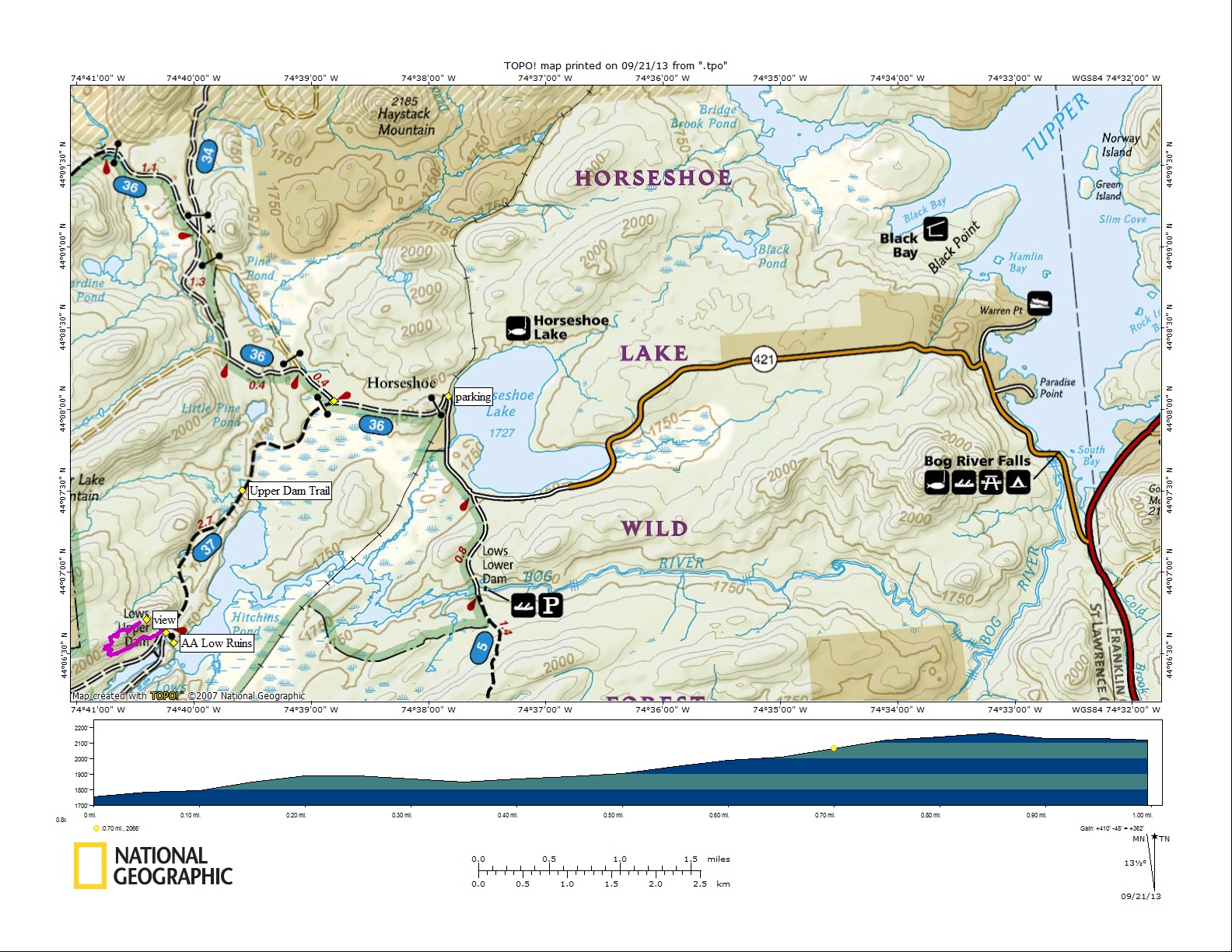
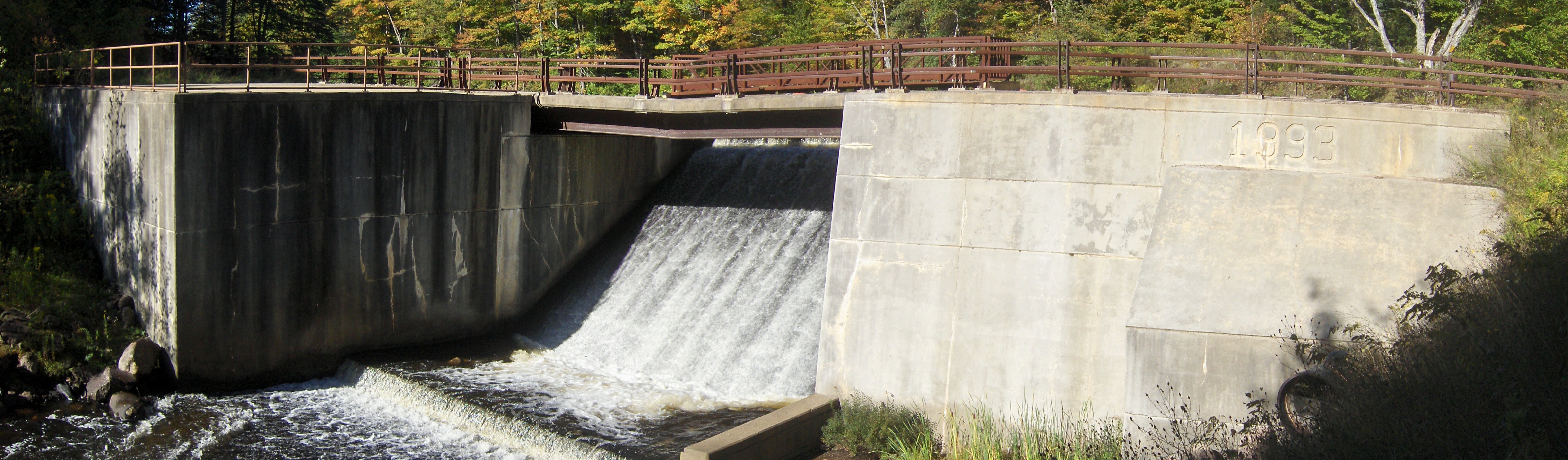
Lows Upper Dam
| CNY Hiking HOME PAGE | Northwest Adirondacks | Hiking in St Lawrence County |