Catskill Forest Preserve
Cherry Ridge Wild Forest
Brock Mountain
Split Rock Lookout
![]()
| CNY Hiking HOME PAGE | Finger Lakes Trail | FLT Eastern/Catskill Section | Catskill Forest Preserve |
|
Finger Lakes Trail Catskill Forest Preserve Cherry Ridge Wild Forest Brock Mountain Split Rock Lookout
|
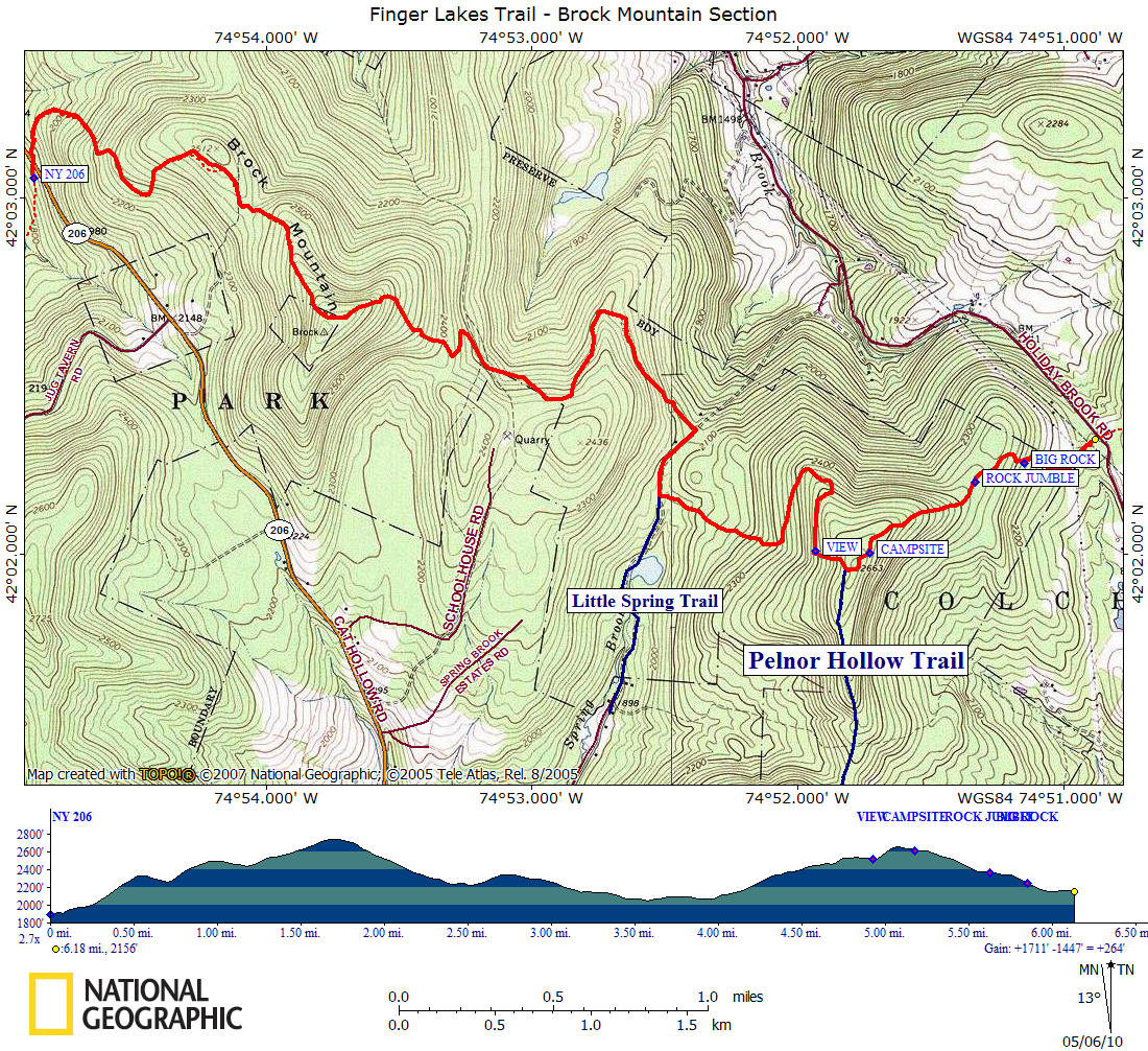
This 6.2 mile section of the Finger Lakes Trail is within the Cherry Ridge Wild Forest section of the Catskill Forest Preserve and climbs 2760 foot Brock Mountain. This section of trail has an overall elevation gain of over 1700 feet and is a moderate to difficult section to hike. You are no longer following white blazes of the FLT within the Catskill Forest Preserve. You are following DEC discs as the FLT follows trails within the preserve. This stretch of the Finger Lakes Trail is featured on map M30 from the FLTC.
From NY 206 the trail follows the Campbell Mountain Trail (blue discs) and climbs steeply up Brock Mountain. At one mile reach a false summit of Brock Mountain and begin the final push to near the summit of Brock Mountain. At 1.7 miles the trail reaches close to the summit and begins a steep descent down the mountain. At 2.0 miles is a flat rock outcrop that provides flat camping but no water. The trail briefly follows an old logging road before veering off the track (watch closely here).
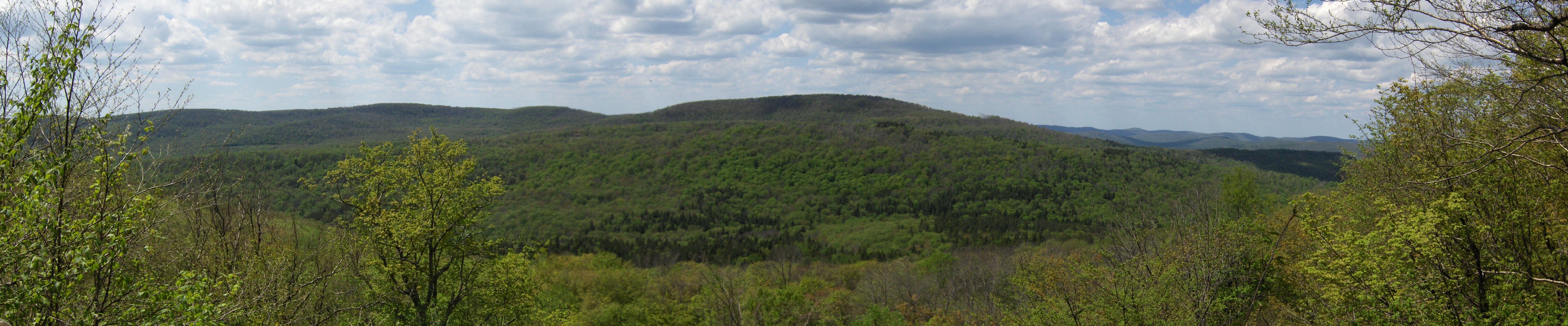
The trail climbs briefly again and makes a sharp left turn, then descends again. The trail reaches an abandoned road, turns right and follows the road briefly to the junction of the Little Spring Brook Trail (yellow discs). Here the trail turns left off the old road and now your following the Pelnor Hollow Trail (blue discs). Now you begin to climb to the Split Rock Lookout and its excellent views to the west. The trail turns left at the lookout. A great spot for a break, especially when you look up the trail to see what awaits you.
From the lookout there is a really steep section of trail. One last steep climb takes you to the junction of the Mary Smith Hill Trail (red discs). The Pelnor Hollow Trail turns goes straight at this junction, however to follow the Finger Lakes Trail you'll need to turn left on the Mary Smith Hill Trail and begin to follow the red discs. Now the trail descends toward Holiday and Berry Brook Road. The trail passes an unofficial trail on your right with views through the trees. Soon you'll leave Cherry Ridge Wild Forest and enter private property. A long stone wall is off to your left as you pass under power lines prior to reaching the road, a trail register, kiosk and parking.
We have pictures, a map and detailed description of this section of trail. Remember that hiking the FLT in the rugged Catskills is much different than other areas. Give yourself plenty of time and pack plenty of water. Water is scarce in this section of trail.
Directions from Syracuse: This section of the Finger Lakes Trail is over 120 miles away from Syracuse and is a 2.5 hour trip. I-81 south to Exit 8 Whitney Point. Turn left on US 11 south, then left on NY 26 to a quick right on NY 206. NY 206 through Downsville to the trail crossing for the Campbell Mountain Trail with a small parking area and kiosk on the right. The GPS coordinates to the small parking area off NY 206 are N42 03.110 W74 54.887 for those who have a GPS devise. The GPS coordinates for the parking area on Holliday & Berry Brook Road are N42 02.327 W74 50.865.
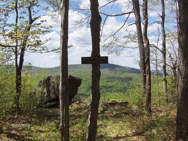
Split Rock Lookout
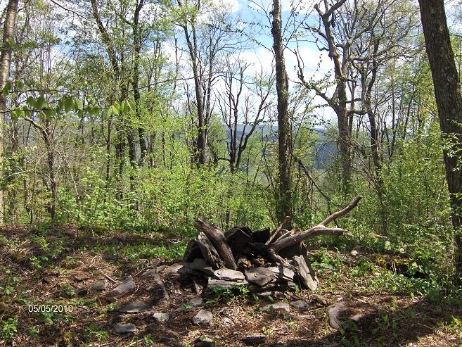
Campsite just east of the Pelnor Hollow Trail JCT
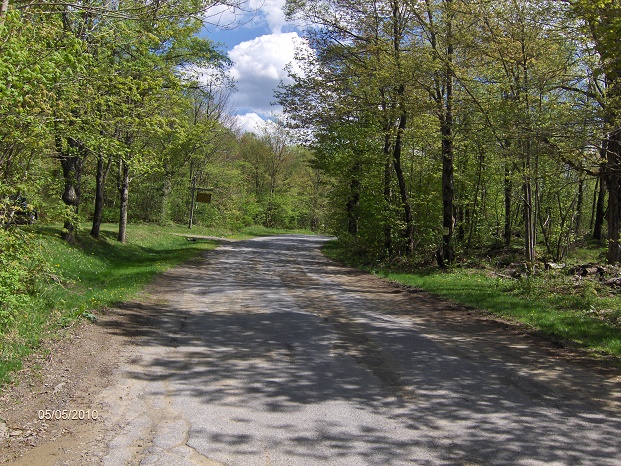
Holliday & Berry Brook Road with parking area on left
Mile Elevation Trail Description 0.0 1892 feet Trail crosses NY 206 (parking, kiosk & register) and follows Campbell Mountain Trail. Ascend. (blue discs).
1.0 2493 feet Reach false summit. Trail descends briefly before climbing again.
1.7 2747 feet Trail skirts near the summit of Brock Mountain. Descend steeply.
2.0 2550 feet Flat Rock Camping Area (no water).
2.25 2336 feet Trail turns left onto an old logging road.
2.35 2291 feet Trail turns right off old logging road.
2.5 2244 feet Trail runs along the park boundary.
2.75 2344 feet Trail veers left away from boundary and descends.
3.65 2068 feet Trail turns right along abandoned road.
3.9 2073 feet Junction of Little Spring Brook Trail and Pelnor Hollow Trail. Turn left and follow Pelnor Hollow Trail (blue discs). Trail climbs.
4.35 2329 feet Trail veers left.
4.6 2442 feet Trail veers right.
4.7 2456 feet Trail veers right.
4.95 2518 feet Split Rock Lookout. Excellent views to the west. Climb steeply.
5.1 2661 feet Junction of the Mary Smith Hill Trail. Pelnor Hollow Trail goes straight. The Finger Lakes Trail turns left and now follows the red discs of the Mary Smith Trail. Descend.
5.2 2616 feet Unofficial campsite along trail with views through the trees. No water.
5.7 2366 feet Trail passing through an interesting "jumble" of large rocks.
5.9 2245 feet Huge Rock on your left.
6.1 2154 feet Pass under power lines.
6.2 2156 feet Reach Holiday and Berry Brook Road. Parking. End of this section. For a continuation see Mary Smith Hill.
| CNY Hiking HOME PAGE | Finger Lakes Trail | FLT Eastern/Catskill Section | Catskill Forest Preserve |