| CNY Hiking HOME PAGE | Virginia BRP Highlights | North Carolina BRP Highlights | Blue Ridge Parkway |
|
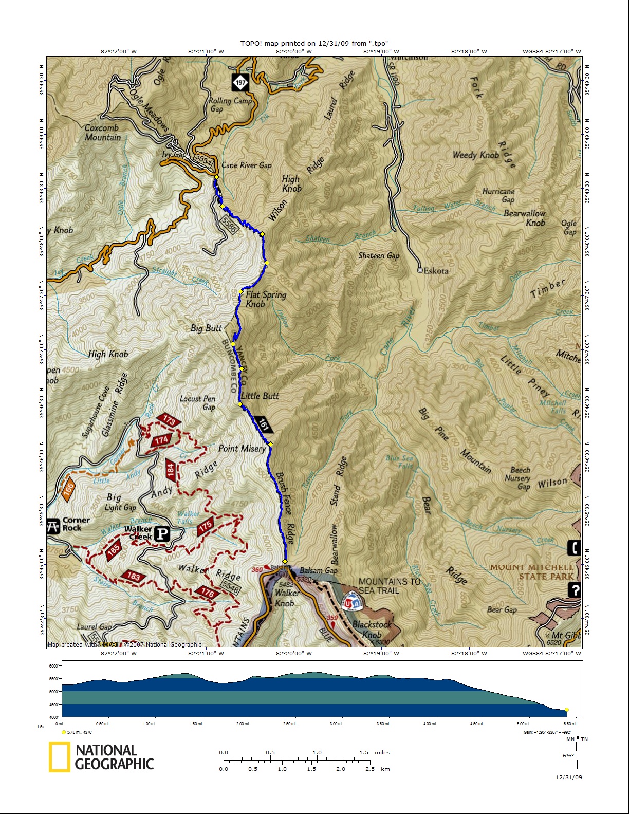
Blue Ridge Parkway in NC Big Butt Trail Point Misery, Little Butt, Big Butt
|
This 5.8 mile trail provides views of Mount Mitchell and the surrounding valley. The trail is off the beaten path and is not used often. It is often hard to follow. Don't let that deter you from exploring this secluded piece of heaven along the Blue Ridge Parkway. Most people only stop to take a picture of the Big Butt Trail sign (sometimes with their own big butts showing).
The trail has white blazes. From the southern trailhead on NC 197 at Cane River Gap, the trail begins ascending gently in a southeasterly direction to the southern end of the Wilson Range and begins to switchback during its elevation gain. Eventually the trail levels out to join an old 4WD road which follows the Buncombe/Yancey County line which is blazed in red. After a couple of miles, the trail narrows. The trail climbs to Flat Springs Knob and then descends to Flat Springs Gap. The trail skirts Big Butt Peak, but does go south to Little Butt Peak. the trail then climbs again to Point Misery Peak where one can see a clear sight of Mount Mitchell. The trail then follows Brush Fence Ridge, enters a Fraser fir stand for the last 0.5 mile before the Balsam Gap pull off on the Blue Ridge Parkway. Primitive camping is available near Flat Springs Gap and Balsam Gap.
If your traveling along the Blue Ridge Parkway and decide to explore this seldom visited, remote area off the parkway, it's a moderate hike to Point Misery of 1.6 miles (3.2 mile round trip) with an elevation gain of just over 400 feet. From the parkway; start at the Balsam Gap pull off. The elevation here is 5320 feet. The trail starts at the south end of the parking area. The Mountains To Sea Trail also passes through here (white circles). Descend into a pine forest with wild flowers galore. The wild flowers, when in bloom, paint the forest floor an array of colors. The trail begins to ascend and there are more tree roots to step over as you continue. The trail leaves Park Service property and enters Pisgah National Forest. Hunting is allowed in this area, so know your hunting seasons. At 0.4 miles enter a dense area of rhododendron, rocky footing and downed trees along the edge of the trail. Soon your walking along Brush Fence Ridge. Even on weekends you'll find solitude on this remote trail.
At 1.6 miles arrive at Point Misery with an elevation of 5715 feet. You have a clear view of Mount Mitchell and the surrounding area. From here the trail steeply descends (you'll have to climb back up on a round trip) on a muddy, rocky path riddled with tree roots. There are several switchbacks as you continue to descend into a hardwood forest with even more wild flowers. At just over two miles into your hike you'll reach a very steep ascent where at times you'll need to use your hands to pull yourself up. At 2.3 miles reach a hard to see spur trail that leads to an open ledge on Little Butt Peak. There are sweeping views to the east of the Black Mountains. Watch your step, as the drop offs are sudden and steep.
From here the Big Butt Trail becomes, at times, overgrown from the lack of use to the point where the hike almost becomes a bushwhack. Soon the trail arrives on a ridgeline with views on both sides of the trail. The trail only skirts Big Butt Peak and never reaches the 5920 foot summit. At three miles reach the high point of the trail. The trail does continue on from here with Flat Spring Knob, elevation 5680 feet, reached at 3.8 miles. Soon the trail begins a long steep descent toward NC 197 and the Cane River Gap. The trail losses 1400 feet in elevation in just 1.5 miles.
| CNY Hiking HOME PAGE | Virginia BRP Highlights | North Carolina BRP Highlights | Blue Ridge Parkway |