New York State Parks
Storm King
![]()
| CNY Hiking HOME PAGE | New York State Parks | Catskill Park |
|
New York State Parks Storm King
|
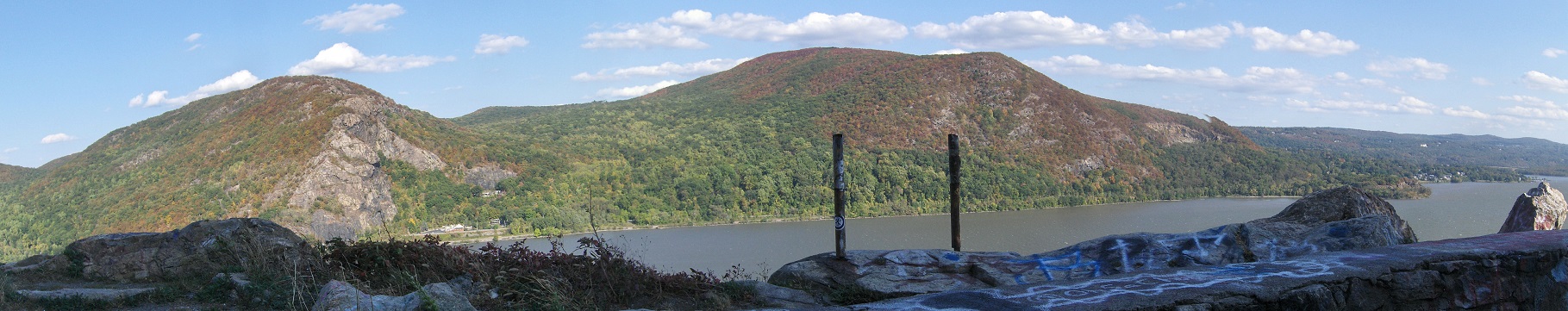
Storm King Mountain looms above the Hudson River like a fortress, dominating the rugged river gorge on the west. Its glowering eastern end rises sheer from the river to more than 1,300 feet and is the dominating feature of Storm King State Park. It offers views of the Catskills, Hudson Highlands and the Hudson River Valley.
Beside the Bobcat Trail, there is nothing easy about the trails in Storm King State Park. However, views of the Catskills, Hudson Highlands and the Hudson River reward hikers far beyond the effort required to arrive at the spectacular views. Most of the trails in the park are short and various loop hikes are possible.
The park is mostly undeveloped except for hiking trails. Look below for information on the trails located in the park.
Bluebird Trail (0.6 mile blue and red) - This trail provides a shortcut across the Stillman Trail (yellow) enabling shorter loop hikes while traversing a hemlock grove and a viewpoint.Bobcat Trail (0.4 mile white) - This trail allows hikers wishing to enjoy the views from the North Ridge of Crows Nest without a climb. (This trail also provides access to the North Ridge of Crows Nest when NY 218 is closed.) It begins on the north side of a small parking lot off the northbound lanes of US 9W about two miles north of its intersection with NY 218 and NY 293 (there is no access to or from the southbound lanes of US 9W). After leaving the parking lot, the trail descends gently, loops to the left, and terminates at the Howell Trail (blue) in 0.4 mile.
By-Pass Trail (0.4 mile white) - This trail connects the Howell Trail (blue) on the southern slopes of Storm King Mountain to the Stillman Trail (yellow) near the brow of the mountain.Howell Trail (3.6 miles blue) - This trail steeply climbs the eastern slope of the North Ridge of Crows Nest Mountain, passing a series of panoramic viewpoints over the Hudson River, the East Hudson Highlands, and Storm King Mountain. Limited parking is available on the east side of the road at the trailhead (additional parking is also available both north and south of the trailhead).
Stillman Trail's (4.0 miles yellow) - Two large stone pillars mark the trails entrance to Storm King State Park on Mountain Road, about a mile north of US 9W. Limited parking is available at the trailhead. It ascends Storm King Mountain passing a number of viewpoints, traverses Butter Hill where the white blazed Butter Hill Trail heads for 0.5 mile to a large parking lot off northbound US 9W. The Stillman Trail then descends passing many other viewpoints until just before reaching US 9W, it bears left and crosses under the highway in a narrow tunnel (this tunnel is open to vehicular traffic, so hikers should use caution). The trail continues ahead on the paved road, reaching the main parking area of Black Rock Forest.Stillman Spring Trail (0.7 mile white) - Since many hikers do not wish to reclimb Crows Nest after hiking the Howell Trail, this trail offers a quick return to cars parked on NY 218.
Here's some popular hikes located in the park according to the NY-NJ Trail Conference website:
- Butter Hill/Stillman/By-Pass Trail Loop from US 9W (2.5 miles, moderate to strenuous)
- Crows Nest Mountain/Howell Trail from US 9W (4 miles, moderate to strenuous)
- Butter Hill/Stillman/Bluebird Trail Loop from US 9W (3.5 miles, moderate to strenuous)
- Stillman/Highlands/Bluebird Trails Loop from Mountain Road (4.1 miles, moderate to strenuous)
Directions: Take US 9W northbound from its intersection with NY 218 and NY 293. Two parking areas are available: the first is about 2 miles north of this intersection and the second, about 0.75 mile further. There is no access from US 9W southbound lanes.
Other parking is available on NY 218 and on Mountain Road in Cornwall.
How do I get to Storm King State Park?
One of the many scenic viewpoints from Storm King State Park (picture courtesy of AndyArthur.org)
| CNY Hiking HOME PAGE | New York State Parks | Catskill Park |
