Sterling
Forest
![]()
| CNY Hiking HOME PAGE | New York State Parks | Harriman State Park | Sterling Forest Trail Map |
|
New York State Parks Sterling Forest
|
The 21,935 acre Sterling Forest State Park is located in the Ramapo Mountains of Orange County amidst one of the nation's most densely populated areas. This scenic piece of forest and tremendous outdoor recreation area was established as a state park in 1998. The state paid $55 million for the land after years of debate of what to do with the land which included the possible development of over 13,000 homes on this pristine land.
The park has over sixty miles of hiking trails to explore. The famous Appalachian Trail skirts the northern section of the park. The park also has numerous ruins from the old mining operations that occurred on the lands by the Sterling Iron and Railway Company up until the 1920's. As you explore this park you can wonder what this land once looked like during the mining heyday and what the landscape of this property may have looked like if developers were able to build the 13,000 homes as well as numerous industrial sites on the land.
For much more information on the park check out the NY State Parks website. The website also has a real nice Trail Map of Sterling Forest. You can also purchase the Sterling Forest Trails
map. Also check out the Appalachian Trail Guide to New York-New Jersey
guide book. Look below for some suggested hikes as well as a few pictures of this beautiful park.
Sterling Forest State Park has over 60 miles of great hiking trails located in the park. A part of the famous Appalachian Trail also passes through the northeastern section of the park. Here are a few of the more popular hikes located in the park from the NY-NJ Trail Conference website:
- Sterling Forest Fire Tower and Iron Mines (4.3 miles, moderate)
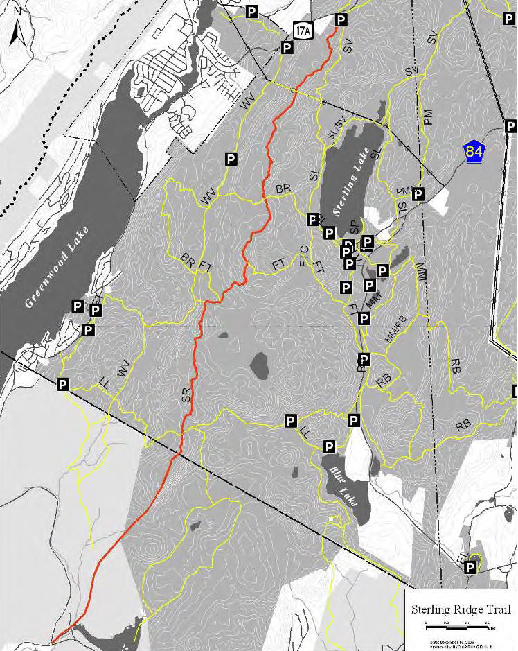
- Sterling Ridge Trail/Fire Tower/Sterling Lake Trail Loop from Route 17A (7 miles, moderate)
- Sterling Lake Loop (4.2 miles, easy to moderate)
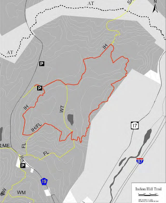
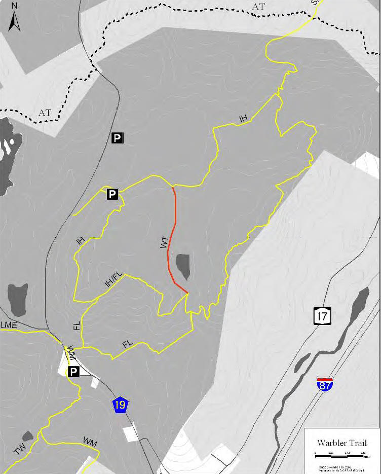
- Indian Hill Loop Trail (3.6 miles, moderate)
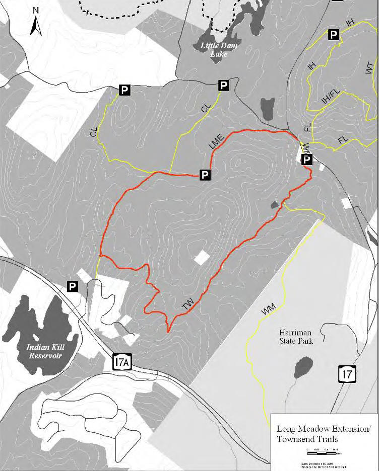
- Townsend Trail/Long Meadow Extension Loop (3.8 miles, easy to moderate)
Check out the Sterling Forest Trail Map from the New York State Parks website. You can also purchase the Sterling Forest Trails
Hiking Trails in Sterling Forest State Park
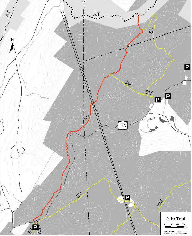
Allis Trail (3.7 miles) - This trail is named after J. Ashton Allis, who was the president of the Fresh Air Club for many years and a veteran hiker and trail builder. The blue blazed trail coincides with the Highlands Trail. For 1.6 miles the trail is parallel to 17A as it begins to make its way through the Doris Duke Wildlife Sanctuary. Crossing both a pipeline and a power line, it passes through oak forest, mountain laurel, and rock outcroppings before reaching Sterling Mountain, where there is a view of the distant Schunnemunk Mountain to the north. The trail continues north and ends at its junction with the Appalachian Trail near Fitzgerald Falls.
AT Connector Trail (0.4 miles) - This trail connects the Indian Hill Trail with the Appalachian Trail and continues north as the Sapphire Trail to a train station in Arden, NY.
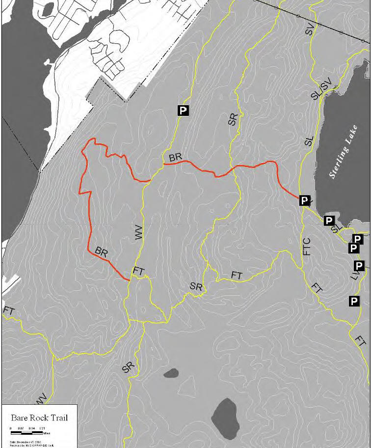
Bare Rock Trail (3.5 miles) - This trail travels to the spectacular Bare Rock Overlook featuring views of Lake Greenwood and Bellvale Mountain. Loop hike options can be created using other trails.
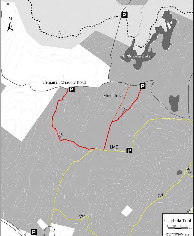
Clayhole Trail (1.9 miles) - This trail runs from Benjamin Meadow Road to the Long Meadow Extension Trail. The trail is very attractive with many ferns, healthy hemlock trees, and interesting rock formations.
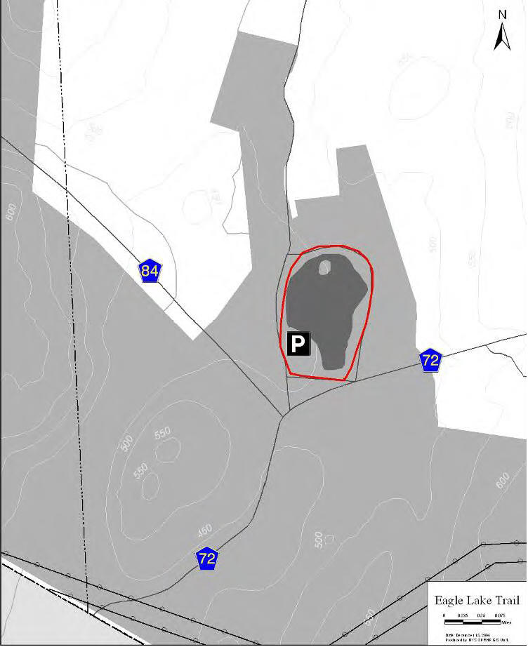
Eagle Lake Trail (0.5 miles) - An easy walk around a small lake. Parts of the trail is paved.
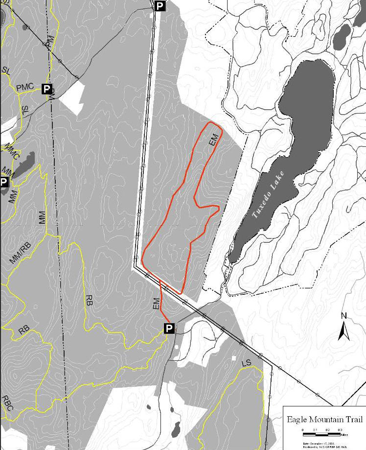
Eagle Mountain Trail (4.6 miles) - This trail was still under construction as of 2009. Access to the trail is from the parking area on South Gate Road. From here it is a short on-road walk north to access the trail which is on the opposite side of a stream that feeds Summit Brook. Heading in a northerly direction, a steep incline with rock outcroppings has to be negotiated in order to reach a wooded plateau beyond which is a power line corridor at 0.5 miles.
Crossing the power line and entering an open, wooded area, the trail leads in a northeasterly direction paralleling the ridge overlooking Tuxedo Lake. Views of the lake may be possible during late fall, winter and early spring. Continuing northeast, the trail passes several erratics to a point where the land falls away steeply. Turning west, the trail then heads northeast again, on a gentle downward slope, through open hardwood forest for about 0.8 of a mile at which point the land again falls away steeply.
At this point, looking in a northeasterly direction, the northern end of Tuxedo Lake can be seen. At this viewpoint, four u-shaped iron pieces are anchored into the ground. Traveling northwest for a short distance, the trail turns where the land begins to fall off then heads southwest on a ridge that overlooks wetlands below. The trail continues down the mountain along the power line.
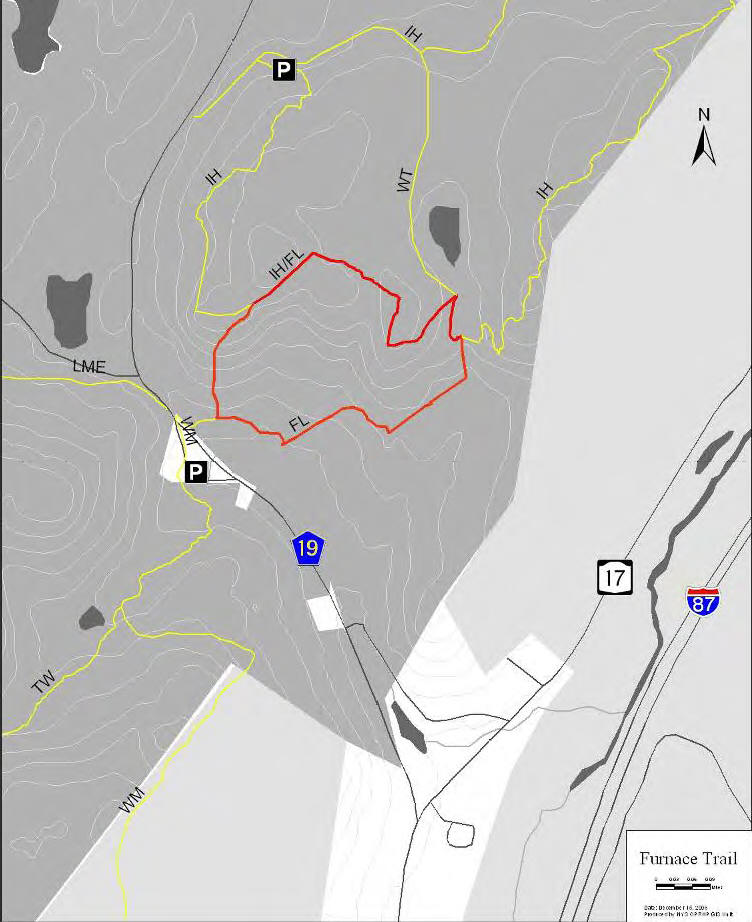
Furnace Loop Trail (1.4 miles) - The trailhead for the Furnace Loop Trail is off Bramertown Road opposite the Wildcat Mountain Trail. It enters the woods over a bridge. The trail meets the Indian Hill Trail and coincides with the Indian Hill Trail along the northern portion of the loop. It then continues south back to the trailhead. The trail goes by the Southfields Iron Furnace, constructed in 1804 – 1806.
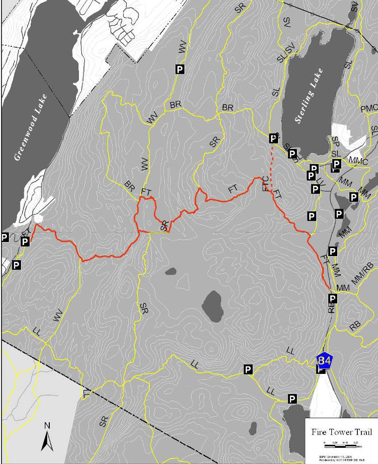
Fire Tower Trail (4.9 miles) - From the seasonal hunting parking lot located off of County Route 84, the trail travels northwest and ascends to the fire tower. This portion of the trail supports vehicle traffic and was used by the fire tower ranger. There are several steep grades and a section of the trail is severely eroded.
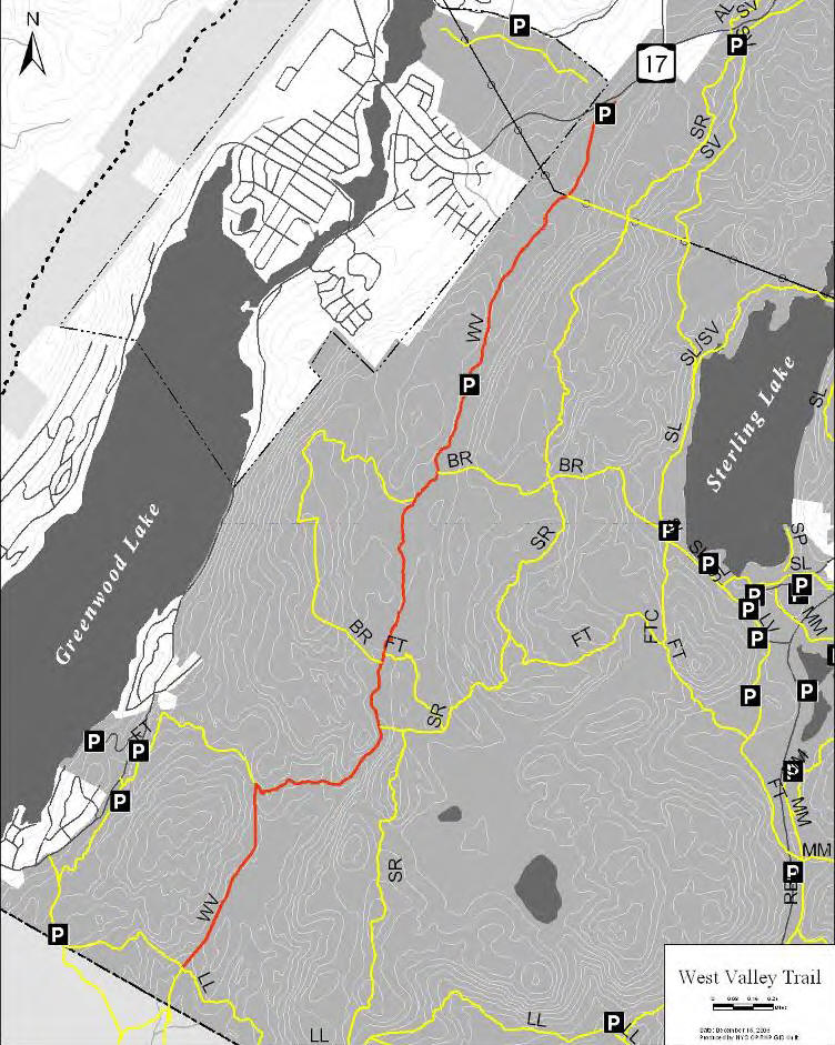
From the fire tower, there is a portion of the Fire Tower trail that coincides with the Sterling Ridge Trail. From this point, the trail descends down a primitive trail, which is a mostly rock hardened surface. There are several sharp descents along with viewpoints of the Greenwood Lake area. West of the intersection with the West Valley Trail, there are only minor slope changes.
Fire Tower Connector Trail (0.5 miles) - This trail connects the Fire Tower Trail with the Sterling Lake Trail and Bare Rock Trail.
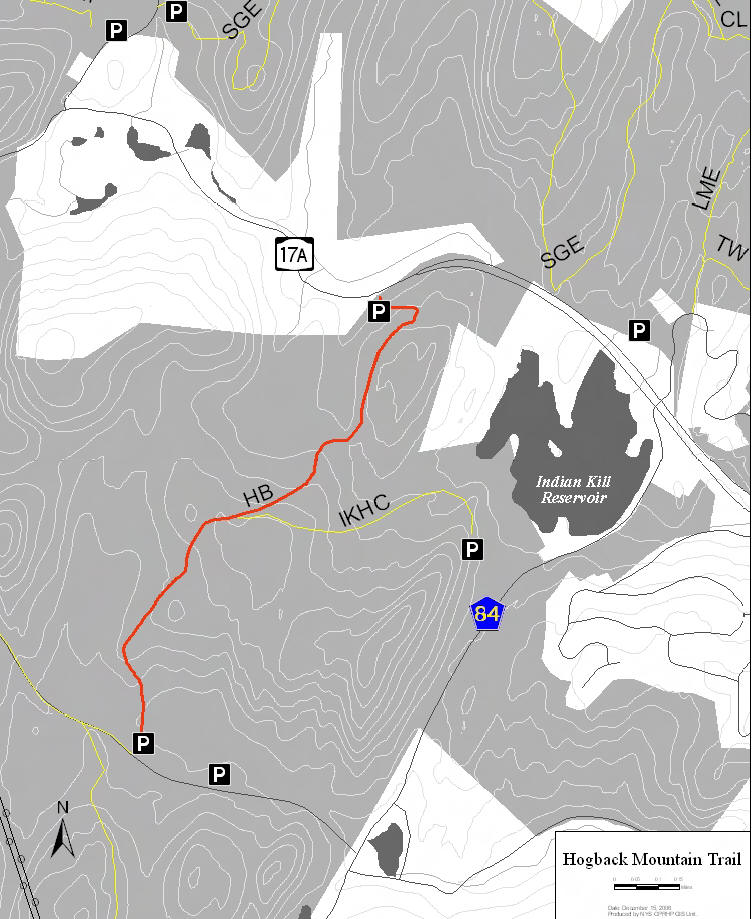
Hogback Mountain Trail (1.5 miles) - The northern trailhead is located on Route 17A near the Sterling Forest Ski Area. The southern trailhead is located near the NYU apartments on Ironwood Drive. In 2009 there was a bridge that collapsed that has closed the southern section of the trail. Generally, this trail is a pleasant trail with no significant views.
Indian Hill Trail (3.8 miles) - The trailhead is located off of Orange Turnpike. The parking area has a portable toilet. There are several seasonal viewpoints along the trail. The trail parallels and cuts through an extensive system of rock walls, both natural and man-made. This area offers opportunities for historic interpretation due to these features and the remains of buildings in the center of the trail loop. From this trail, connection can be made to both the Appalachian Trail to the north and the Furnace Loop trail to the south.
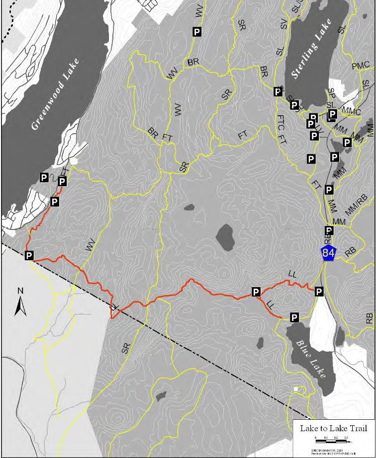
Lake to Lake Trail (4.2 miles) - The Lake to Lake Trail traverses the southern portion of the park. Traveling from west to east, the trail begins near the Village of Greenwood Lake, where the parking area is located along East Shore Drive. The trail generally parallels the New Jersey border with a portion of the trail dipping into New Jersey briefly. The trail crosses the intersection with the West Valley Trail and then crosses the Sterling Ridge Trail. It terminates at Blue Lake, where there is a parking area and portable toilet facility.
Long Meadow Extension (1.5 miles) - This trail is used by mountain bikers as well as hikers and cross country skiers in the winter. A nice 3.8 mile loop is created with the Townsend Trail.
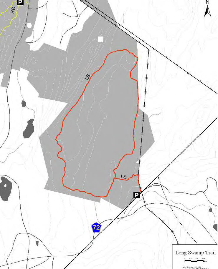
Long Swamp Trail (3.0 miles) - The trailhead and parking area for the Long Swamp Trail are located off of Eagle Valley Road. The loop is accessed by a short trail that follows along the shoulder of the road then travels up a power line right-of-way. The section along the shoulder of the road is very narrow and should be reroute off of the road, onto park land.
In general, the trail has a gentle to moderate grade with the major uphill portion along the power line access right-of-way. Once the loop portion of the trail is reached, the trail widens and becomes a more moderate grade. There is a wet section of the trail on the southern part of the loop.
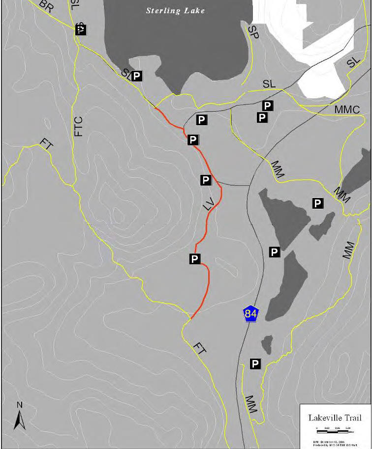
Lakeville Trail (0.8 miles) - The Lakeville Trail follows an abandoned paved roadway formerly known as the Sterling Lake Road. This trail is gated on its north intersection with Old Forge Road to prevent public vehicular access. This trail serves as a multiple use connection between the Visitor Center and the McKeags Meadow Trail.
The trail passes through the historic village of Lakeville where now only foundations of the former iron mining village remain. Trail users are reminded of the history here and the past lives that struggled to get by. Many foundations are less than 40 feet away from each other. Locals refer to the area as Ghost Town.
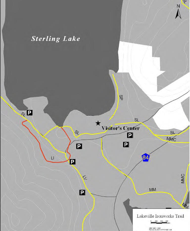
Lakeville Ironworks Trail (0.5 miles) - From the Visitor Center, patrons can walk south on the Sterling Lake Trail to the section that is on West Sterling Lake Road, where you will turn left onto the Lakeville Ironworks Trail. The trail goes up a small hill past the Lake Mine then takes a sharp left turn past the remains of the early 20th century iron ore processing structures – a cable house, crusher, dryer, ore separator, and storage bin.
The trail then follows the pathway worn by the miners themselves past the older Sterling Mine and crosses Old Forge Road. Once across Old Forge Road, the trail crosses Sterling Creek on a yet to be completed foot bridge and passes the last remaining miner’s home in Lakeville. The trail then takes a sharp left turn, crosses back over Old Forge Rd. and passes the Sterling Furnace before meeting back up with the Sterling Lake Trail.
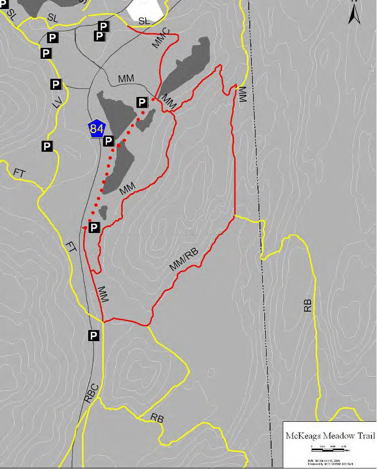
McKeags Meadow Trail (3.1 miles) - The trailhead is off of Long Meadow Road (Rt. 84) where there is a parking area with a portable toilet. The trail climbs gradually over wet and eroded spots. Traveling clockwise, at 0.6 miles, the trail surface levels off and passes by McKeags Meadow before descending past the intersection with the Red Back Trail.
At the bottom of the descent and to the north, a sand pit/abandoned firing range was noted. The trail then heads south and approaches an area flooded by beaver, which impacts the trail. The trail can only be negotiated with some difficulty. The trail continues to a ‘T’ juncture with an unmarked trail paralleling Long Meadow Road, which runs north - south.
The marked trail turns north and crosses two wooden bridges. There is no tree canopy along this entire stretch. Approaching Laurel Meadow Ponds, the trail becomes a narrow, overgrown path that requires much maneuvering to pass wet areas created by pond overflow near fishing spots at the south end of the pond. This segment of trail is difficult to traverse.
McKeags Meadow Connector Trail (0.4 miles) - The McKeags Meadow Connector trail connects the Visitor Center to the McKeags Meadow Trail. The trail begins as part of the old switchback for the railroad and then continues on an old woods road.
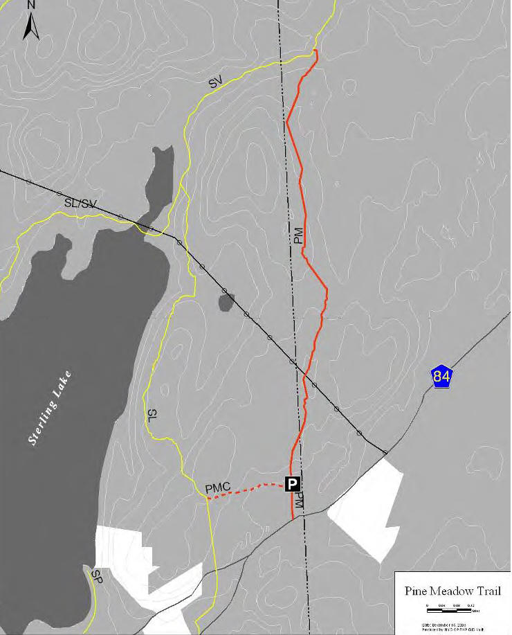
Pine Meadow Trail (1.4 miles) - The trailhead is located along Old Forge Road aka County Route 84, just east of the Sterling Forest State Park Visitor Center. There is a small year round parking area available at the trailhead. Generally the trail travels through hemlock. Two mine pits are found near the trail; one has water flowing into a two foot opening. The trail terminates at the Sterling Valley Trail, just north of Sterling Lake. Hikers may encounter wet sections on parts of the trail.
Pine Meadow Connector Trail (0.25 miles) - The Pine Meadow Connector Trail connects the Pine Meadow Trail to the Sterling Lake Trail. This trail can be difficult to follow due to poor blazing.
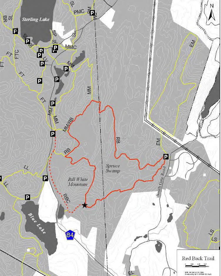
Red Back Trail (6.7 miles) - There is a parking area on South Gate Road. The trail assessment began at this point and was conducted in a clockwise direction. The trail ascends a series of low hills in a southwesterly direction until gently descending the south side of Bill White Mountain. At this point turn north and go over Bill White Mountain and down its north face which has a somewhat rocky path. Upon reaching the bottom of the hill, the trail goes westerly along a section where the trail travels through a major active beaver area.
At this point, the trail is usually under water until a reroute is developed for this area. The trail continues before crossing a stream (approximately 40 feet wide) below the beaver dam. From here, the loop trail turns south passing the Red Back Mine at mile point 5.7. The trail is somewhat eroded along this section. Immediately before the swamp, the trail turns east at mile point 5.8 and then passes Spruce Swamp and ascends an old mining access road until it reaches a utility maintenance road. Continuing easterly, the trail passes Moorhead Mine at mile point 6.4 and returns to the parking area for a total distance of 6.7 miles.
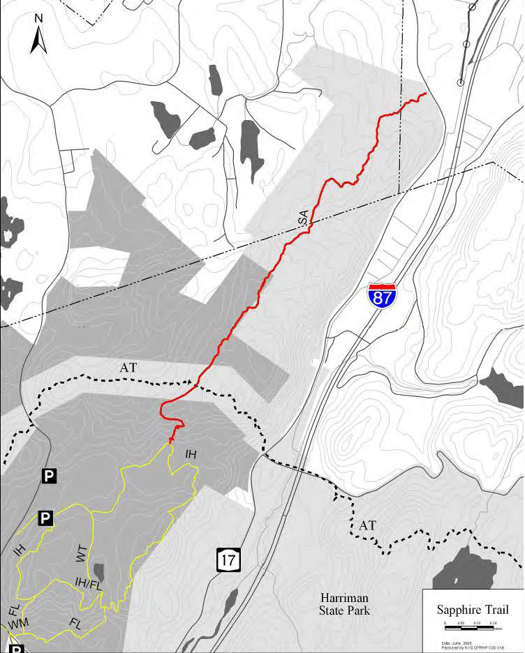
Sapphire Trail (2.6 miles) - This trail provides a connection between NY 17/Harriman Train Station and the Appalachian/Indian Hill trails. Beginning at NY 17 opposite the train station, the trail is in Harriman State Park and doesn't enter into Sterling Forest State Park until 1.8 miles. The trail leaves NY 17, passes a park access gate and continues across a roadway (the former highway) and enters a mixed pine/hardwood forest.
The trail in this area is a footpath that meanders through former farm fields as it ascends the ridge. At 1.0 miles the trail turns left onto a woods road and descends to a stream crossing where it bears to the right onto another wood road. The trail passes a former house site and begins to ascend. Here the trail leaves the woods road several times to avoid washed out areas. The trail enters Sterling Forest® and shortly after crosses two streams before continuing on to meet the Appalachian Trail at 2.6 miles.
This trail leaves the AT and continues in a southerly direction to meet with the Indian Hill Loop Trail. This part of the trail is also known as the AT Connector Trail. You'll find large rocks under your feet that can be dangerous when the trail is leaf or snow covered on some of this section.
Sears Hunter Trail (1.4 miles) - Starting at the Sears Hunter parking area, this trail follows an existing wood roads and continues through wooded areas in overgrown farm fields. The trail then heads south to connect with the West Valley Trail. The eastern section of this trail creates a connection to other trails in the network. After leaving the wood roads, the trail begins uphill to make a crossing of Old Tuxedo Road near its intersection with NY 17A. Once across Old Tuxedo Road, the trail travels parallel to NY 17A on a hillside west of the highway. There are two stream crossings on this section before the trail makes a connection to the Allis Trail just west of the Allis/NY 17A crossing.
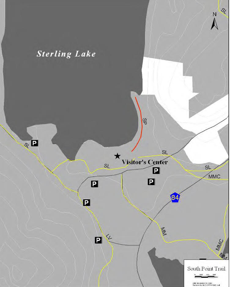
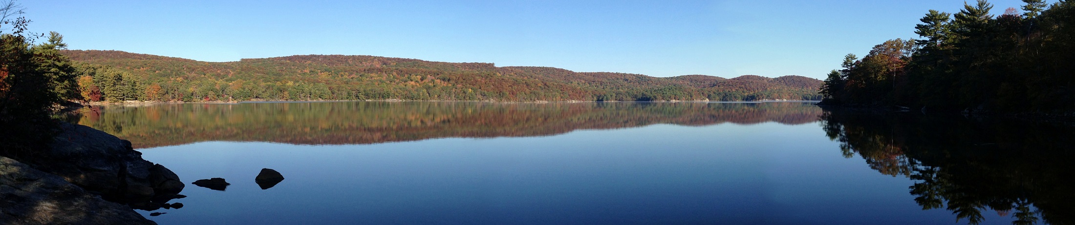
South Point Trail (0.4 miles) - The trail begins at the Sterling Forest State Park Visitor Center. The trail is wide at the beginning and then narrows. The trail ends at a large rock with a magnificent view of Sterling Lake and the surrounding mountains.
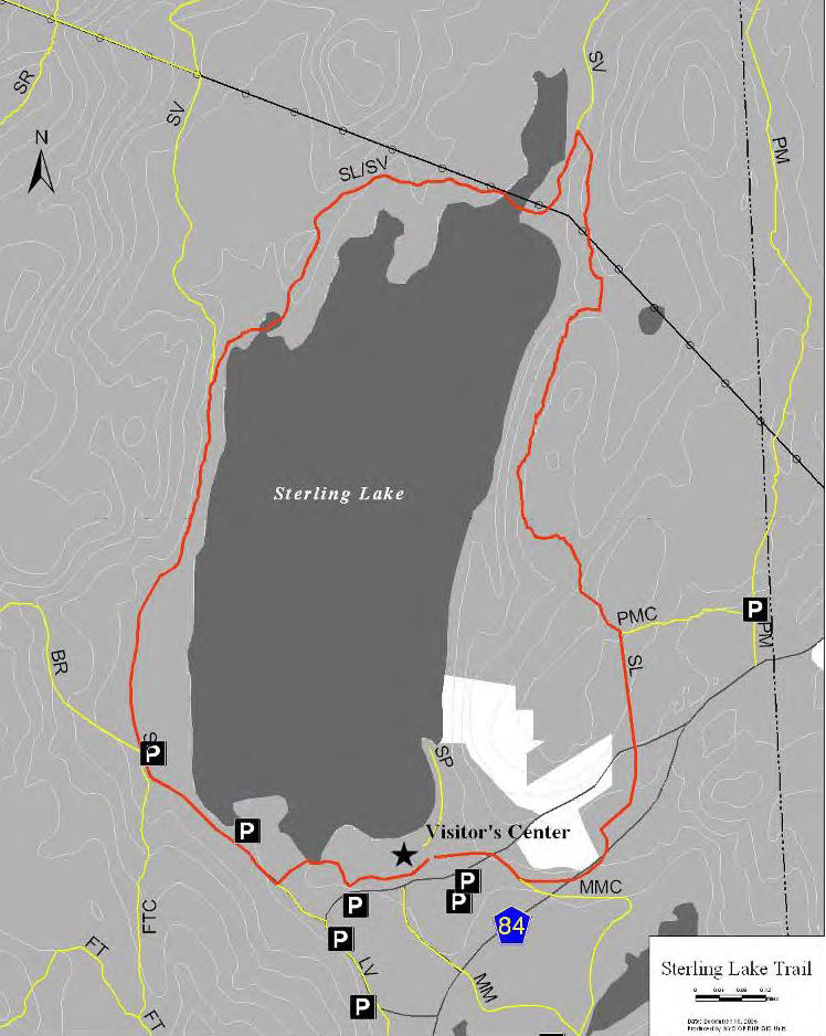
Sterling Lake Trail (4.0 miles) - The trail begins at the Visitor Center. The trail travels west and then north along the western side of the lake to the point where the Sterling Valley Trail diverges from the Sterling Lake Trail. The trail is relatively wide, with gently rolling terrain (except for two relatively short climbs).
The Sterling Lake and Sterling Valley trails coincide along the northern part of Sterling Lake. The trail passes over a causeway. The trail along the eastern side of the lake is generally more rugged, with steeper and more numerous grades, as well as rockier terrain. Near the southern end of Sterling Lake, the trail crosses Old Forge Road and then returns to the point of beginning at the Visitor Center.
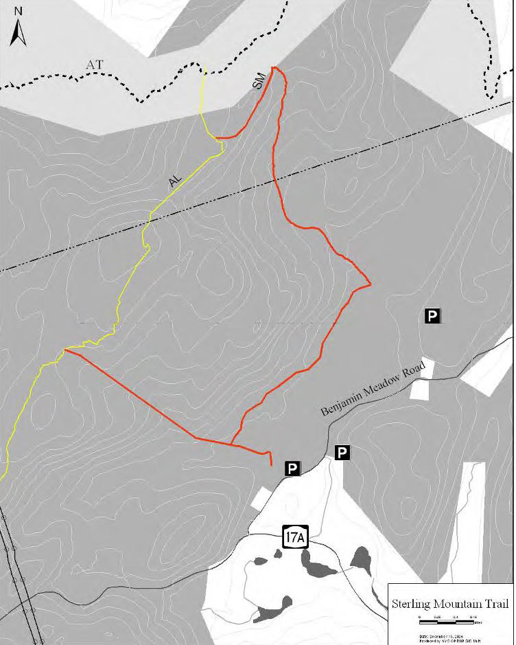
Sterling Mountain Trail (3.3 miles) - As of 2009 this trail was closed and not open to hiking as it was still under construction. The trail begins at the parking area of the old Sterling Gardens on Benjamin Meadow Road. The trail proceeds north crossing a brook at 0.2 mi., the trail then turns right and parallels a marsh area.
At 0.3 mi., the trail passed a huge glacial erratic. Continuing to the end of the marsh area, passing an old road to the north, the trail reaches another wood road at 0.7 miles. The trail travels to the north until reaching the boundary markers of the Appalachian Trail Corridor at 1.2 miles. Entering the corridor, the trail turns northwest and begins climbing a steep slope, traveling past blueberries, rock outcroppings and fallen trees, eventually reaching the Allis Trail, as it descends the northeast side of Sterling Mountain.
Hikers can then follows the Allis Trail southwest for 0.9 miles and then the trail splits and the Sterling Mountain Trail travels southeast back to the Sterling Gardens area. This half mile section of the trail is highly eroded and can be difficult to walk.
Sterling Ridge Trail (8.0 miles) - This trail is very popular due to the numerous views as well as its location to other trails allowing hikers to create numerous loop hike options. The Sterling Ridge Trail coincides with the long distance, regional Highlands Trail. The trail provides access into New Jersey and Passaic County parkland. The southern trailhead is located in New Jersey at the junction of Greenwood Lake Turnpike and East Shore Road. The trail enters Sterling Forest State Park at the New York – New Jersey border, from the Passaic County parkland, Tranquility Ridge.
Once the trail enters New York, it crosses several trails, including the white blazed Lake-to-Lake Trail. Heading north, the trail makes several ascents and descents, crossing several seasonal wet areas west of the Cedar Pond area. There are several viewpoints along the trail on the way to the Fire Tower. At 1.8 miles, the Fire Tower Trail joins the Sterling Ridge Trail from the west.
After a series of four rather steep ascents, the Sterling Ridge Trail reaches the Sterling Forest Fire Tower at 2.4 miles, with 360° views. Here, the Fire Tower Trail leaves to the east, while the Sterling Ridge Trail continues north over undulating terrain. The orange blazed Bare Rock Trail crosses at 3.4 miles. The trail continues north providing three good views of Sterling Lake from rock outcrops along the way.
The trail crosses a power line at 4.9 miles then the yellow blazed Sterling Valley Trail comes in from the right on a woods road at 5.9 miles. The Sterling Ridge Trail continues through a parking area and ends at Route 17A, directly across from the Allis Trail trailhead. The Highlands Trail continues north along the Allis Trail.
Sterling Valley Loop Trail (5.8 miles) - This loop trail begins along Route 17A at the trailhead/parking area which is also shared by the Sterling Ridge and Allis Trails. There is also a small trailhead located off Ironwood Drive, by the NYU apartments. At the northern end of Sterling Lake, the Sterling Valley Trail is co-aligned with the Sterling Lake Trail. The Pine Meadow Trail terminates at the Sterling Valley Trail along the eastern side of the trail.
Townsend Trail (1.6 miles) - The trail has access points on Bramertown Road to the north and through Clinton Woods off of NY 17A to the south. The route of this trail generally follows a utility road and a gas line road. Many hikers use this trail and Long Meadow Extension to create a pleasant loop hike.
Warbler Trail (0.5 miles) - This trail runs approximately ½ mile in a north-south direction past the former mountain top farm, then narrows to single track foot path which connects to Indian Hill Loop as it passes a 2 ¾ acre farm pond. The pond is visited by fishermen, wildlife enthusiasts and birders. This trail had not officially opened as of 2009.
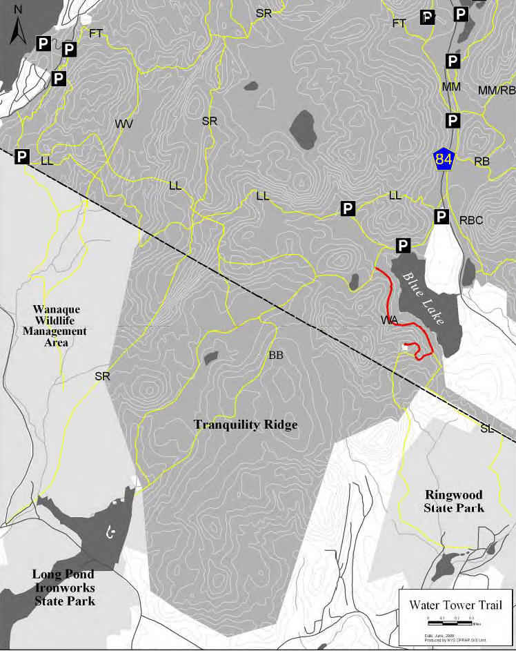
Water Tower Trail (1.0 miles) - This trail follows a gravel road on the southwest side of Blue Lake, which is wide enough for two lanes of traffic at some points. Where it leaves the side of the Lake and climbs the hillside it narrows to a single vehicle width and reverts to rock / gravel and ascends gently to the tower. The trail terminates at a water tower, which is owned by the United Water Company. There are proposals to extend this trail to give access to New Jersey trails.
West Valley Trail (4.5 miles) - The West Valley trailhead is located along NY 17A, one mile northeast of Greenwood Lake. The parking area is situated on a fairly steep incline and is difficult to negotiate. The lot allows for parking for approximately 5 vehicles. During hunting season, park patrons are allowed to drive past this trailhead parking lot and down the trail for approximately 1.2 miles to a large open area.
Located here is a gate which prevents hunters from driving any further. After this gate, the trail then becomes more of a footpath but is still fairly wide. The trail travels another 1.3 miles to the intersection with the Fire Tower Trail. The trail then coincides with the Fire Tower Trail for approximately 1 mile. The last portion of the trail is approximately 1 mile long and terminates at the Lake to Lake Trail.
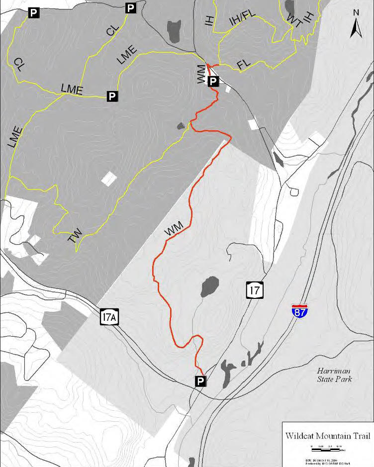
Wildcat Mountain Trail (2.3 miles) - The Wildcat Mountain Trail is located partially in Sterling Forest State Park and mostly in Harriman State Park. The southern trailhead is at the NY 17A Park and Ride on Harriman property. The trail climbs Wildcat Mountain and passes by Spruce Pond. After the trail passes Spruce Pond, it enters Sterling Forest State Park.
A portion of the trail in Sterling Forest State Park coincides with the Townsend Trail. The trail ends at Bramertown Road across the road from the trailhead to the Furnace Loop. There is limited parking at the northern trailhead.
Park address: 116 Old Forge Road
Tuxedo, NY 10987How do I get to Sterling Forest State Park?
| CNY Hiking HOME PAGE | New York State Parks | Appalachian Trail in New York | Appalachian Trail - NY 17A to NY 17 |