
| CNY Hiking HOME PAGE | Northville-Placid Trail | NPT-Whitehouse to NY 8 | Hiking in Adirondack Park |
|
Hiking in the Adirondacks Northville-Placid Trail Silver Lake Wilderness Northville to Whitehouse
|
A new kiosk was constructed to mark the southern beginning/end of the Northville-Placid Trail in the small hamlet of Northville. There is a parking area for the trail located at the kiosk. There is a register and information about the trail at the kiosk. The trail starts out following roads including NY 30 near Northville to County Route 6 toward Upper Benson. There is a reroute under way to eliminate this long road walk. There is a map of this future reroute below, as it is featured on the Kiosk in Northville. Look below for more info.

Map of reroutes in the Northville area from the DEC Kiosk
Northville to Whitehouse
The southern start of the Northville-Placid Trail is located at a parking area with a DEC Kiosk in the hamlet of Northville. It is behind a ice cream store along South Main Street, just south of the intersection of Bridge Street. The GPS coordinates of the parking area are N43 13.542 W74 10.278 for those who have a GPS devise. There is a trail register at the Kiosk.
From here it is a 8.6 mile road walk to reach the first off road section of the NPT. This has just changed in late September 2015 as they completed construction of a new off road section of the trail located closer to Northville. We will be updating the below info soon.
From the Kiosk head north (right) on Main Street and then west (left) on Bridge Street. There is a Tops grocery store located a short distance north on Main Street. Do you need supplies? This is the last chance for a long, long time.
Take Bridge Street out of town and then right onto busy NY 30. Walk safely on busy NY 30 to County Route 6 aka Benson Road, where you will take a left. You've already walked nearly four miles to get to this point. Walk 5.1 miles on County Route 6 to reach the first off road section of the NPT, opened in 2013. In a short distance you will reach scenic Woods Lake, where there are a number of campsites near the lake.
You are now traveling on a newly built trail that was opened in 2013 as the trail travels toward Grant Lake. Just over six miles of newly constructed trail now takes hikers off the local roads and into the wilderness.
Eventually you will reach the end of Godfrey Road and back to the "original" Northville-Placid Trail. This is where many thru hikers used to begin their journey, in an area known as Upper Benson. You have traveled 15.2 miles from the Kiosk in Northville. At 15.4 miles you'll cross the North Branch of West Stony Creek. At 16.5 miles the trail crosses Goldmine Creek. At 18.2 miles a spur trail travels 0.1 miles to Rock Lake on your left. At 19.2 miles you cross the West Branch of the Sacandaga River.
At 19.9 miles Meco Lake is off to your right and reach Silver Lake Lean To at 20.7 miles. The trail passes close by Canary Pond at 22.9 miles. There are primitive camping opportunities near Canary Pond. After passing through a wet area on puncheons, reach Mud Lake Lean To at 26.1 miles. The trail reaches a col at 27.0 miles to start a major descent that ends at the crossing of the West Branch of the Sacandaga River on a suspension footbridge at 28.7 miles.
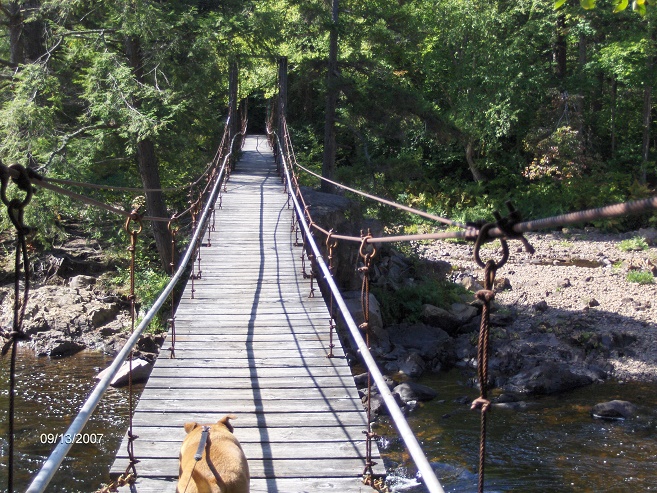
Suspension Bridge over West Branch Sacandaga River
Across the river you'll notice the ruins of an old fireplace and at 28.9 miles you'll reach an old road plus a trail register. This is the end of this section. The Northville-Placid Trail turns left. Turning right and following the old road will bring you to the end of West River Road and a parking area.
Be ready to encounter wet sections caused by beavers, especially between Silver Lake and Canary Pond.
Be sure to check out the NY DEC website at Adirondack Trail Information for updated trail conditions. You can find more information from the official Northville-Placid Trail website. Look below for some videos featuring a through hike of this stretch of the Northville-Placid Trail.
Mile Elevation Description (Northville to Whitehouse) 0.0 781 feet Kiosk & Trail register in Northville off Main Street. Parking Area. Turn left on Bridge Street. 0.5 781 feet Bridge over Sacandaga River. Soon turn right on NY 30 North. 3.8 785 feet Turn left on County Route 6. 8.6 1396 feet Turn right off road onto trail entering woods. 8.9 1380 feet Woods Lake. 15.2 1449 feet Reach the end of Godfrey Road and the original NPT. 15.4 1510 feet Cross North Branch West Stony Creek.
16.5 1712 feet Cross Goldmine Creek.
18.2 1999 feet Rock Lake is on the left. A short 0.1 mile spur trail leads to the shore.
19.2 1867 feet Cross West Branch Sacandaga River at the western end of an old clearing, then bear sharply right up the west bank of river
19.9 2113 feet Meco Lake is on your right.
20.7 2038 ft Silver Lake Lean To
22.7 1995 ft Cross stream on footbridge
22.9 2059 ft Canary Pond is off to the left.
26.1 1739 ft Mud Lake Lean To (destroyed in 2011)
26.4 1780 ft Cross small stream
27.0 1929 ft Reach col between Grindstone Mountain and Mud Lake Mountain. Begin descent toward river.
28.7 1296 ft Cross the West Branch of the Sacandaga River on a suspension footbridge.
28.8 1292 ft Ruins of old fireplace on your left.
28.9 1311 ft Reach old road and trail register. End of this section. N-P turns left. Trail to right leads 0.1 mile to parking area at end of West River Road.

Kiosk & trail register in Northville


| CNY Hiking Home Page | Hiking in Adirondack Park | Northville-Placid Trail |