
| CNY Hiking HOME PAGE | Finger Lakes Trail | NCT in Central New York | Hiking in Cortland County |
|
Hiking in Cortland County North Country Trail Taylor Valley State Forest Mount Tego, Mount Roderick
|
This 7.4 mile stretch of the North Country Trail features beautiful Taylor Valley State Forest. The NCT coincides with the white blazed Finger Lakes Trail during this section of trail. The trail starts off NY 41 near Solon at the start of this section. There was a section of trail that was closed on PRIVATE PROPERTY at NY 41. This section now starts off Telephone Road at the large parking area.
The trail then crosses Telephone Road and climbs to the summit of Mount Roderick (elevation 1909 feet). You'll pass the foundation ruins of an old home and a grave site for the old landowners from long ago. Soon there are winter views on your right through the trees. This is a very scenic section of the trail and is one of the best sections of the NCT in New York. The trail passes Hill Top Pond on your left before beginning a long descent toward Cheningo Creek and crossing the creek. Currently there is no bridge over the creek and it can be a difficult & dangerous crossing in high water. A new crossing was built in 2009 that utilizes large boulders to cross the creek (see panorama above) at a very scenic point along the creek.
The trail reaches the DEC Cheningo Day Use Area after climbing old stairs, passing a kiosk and crossing Taylor Valley Road. There is a picnic pavilion here and is a popular spot for camping. The trail now begins a 700 foot ascent toward Allen Hill. Soon the trail reaches private land for it's descent toward Cheningo Solon Road. This section of trail is CLOSED during hunting season from Oct 1 to Jan 1. Please respect the landowners request and stay off this section of trail during those dates.
Check below for a map and description of this section of the trail. There are a couple of loop hike options utilizing the NCT and seasonal dirt roads in the forest. Check out the Mount Roderick Loop and Seacord Hill Loop.
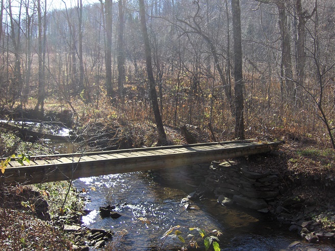
Footbridge over Pritchard Brook
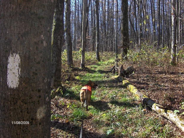
North Country Trail on Mount Roderick
Mile Elevation North Country Trail Description (west to east) 0.0 1500 feet Cross Telephone Road.
Parking at bus/snow plow turnaround 80 yards to the west.
0.7 1730 feet Cross seasonal dirt Cortland Two Road.
Limited parking.
1.3 1900 feet Mount Roderick summit. Some winters views on your right as you continue along the trail toward Hill Top Pond.
1.7 1833 feet Trail register.
2.8 1802 feet Pass Hill Top Pond on right, then reach Cortland Two Road and follow the seasonal dirt road downhill. Parking.
3.9 1253 feet Trail veers right off the seasonal dirt road.
4.4 1217 feet Views of Taylor Valley & surrounding hills on your left.

4.8 1179 feet Cross Chenango Creek on large boulders. No bridge. Can be difficult during high water times. The trail follows an old woods road, then turns right following another woods road.
4.9 1223 feet Trail veers right off old road, goes up old stairs, pass North Country Trail Kiosk, then cross Taylor Valley Rd. Reach Cheningo Day Use Area. Parking, picnic pavilion & tables, camping. Look below for a video from YouTube and a few pictures.


5.0 1230 feet Begin ascending on switchbacks.
6.4 1933 feet Cross old grassy road.
6.7 1871 feet Trail veers right.
7.1 1748 feet Leave Taylor Valley State Forest. Entering PRIVATE PROPERTY. NOTE: Trail is CLOSED BETWEEN OCTOBER 1st and JANUARY 1st for HUNTING on this land.
7.4 1439 feet Cross Cheningo Solon Pond Road. End of this section. For a continuation see Cuyler Hill State Forest.


| CNY Hiking HOME PAGE | Finger Lakes Trail Central Section | North Country Trail in Central New York |


