Finger Lakes Trail
Pharsalia Woods
State Forest
![]()
| CNY Hiking HOME PAGE | Plymouth Loop | FLT Central Section | Hiking in Chenango County |
|
Hiking in Chenango County Finger Lakes Trail Pharsalia Woods State Forest
|
The Finger Lakes Trail crosses NY 23 just south of Pharsalia WMA and enters Pharsalia Woods State Forest along a section of trail built in 2016. This area was hit by a tornado in May 2011 that devastated part of the forest. You may still see some of the tornado damage. There is one shelter available for backpackers along this stretch of the trail.
The trail has a few minor up and downs within the state forest, making this section of trail easier than other sections of the FLT. There are different types of forest that you will encounter. Parts of the trail follow seasonal dirt roads briefly. Parts of the trail travels past old stone walls and if you look very hard, you may see the remnants of the farmers who had once made this area their homes many years ago.
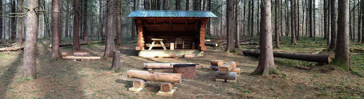
The FLTC placed a memorial stone bench in honor of Ed Sidote aka Mr. FLT along the trail. The Pharsalia Woods Lean To was constructed in late 2013 and is located near the memorial bench. This shelter features a picnic table, fire ring, benches, a rocking chair, tenting sites and an open air privy. This lean to is one of the nicest along the Finger Lakes Trail. This stretch of the Finger Lakes Trail is featured on map M23 from the FLTC.
DIRECTIONS: From Syracuse take I-81 south to Exit 15. From Lafayette take US 20 EAST to NY 91 South. In Fabius turn left on NY 80 East. Just past entering Madison County turn right on East Lake Rd. Turn right on NY 13 South and in DeRuyter turn left at the stop sign onto Albany Street. This road now turns into Crumb Hill Rd. Turn right on Maripossa Rd, then in South Otselic, turn right onto NY 26 South.
After you pass the Otselic Fish Hatchery, turn left on County Route 42 (sign for Norwich & Bowman Lake State park). Now turn left on NY 23 North. In just about one mile turn (veer) right on North Rd. When the pavement ends, turn left on Center Rd. In another mile (after farm on right), turn right onto Fred Stewart Rd (seasonal dirt road). Shortly you will see a FLT sign and a small pull off parking area to the right. Park here. The GPS coordinates are N42 35.994 W75 42.500 for those who have a GPS devise.
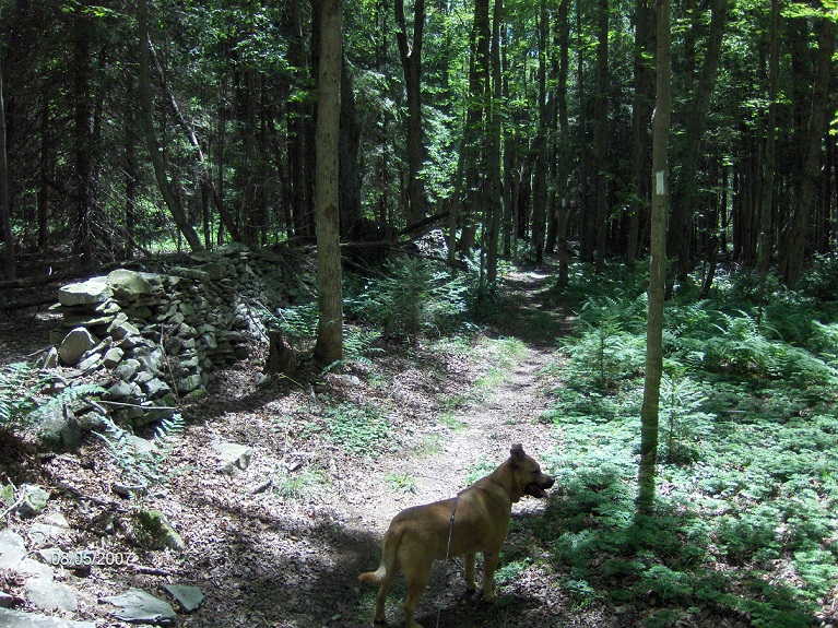
Finger Lakes Trail passing by an old stone wall
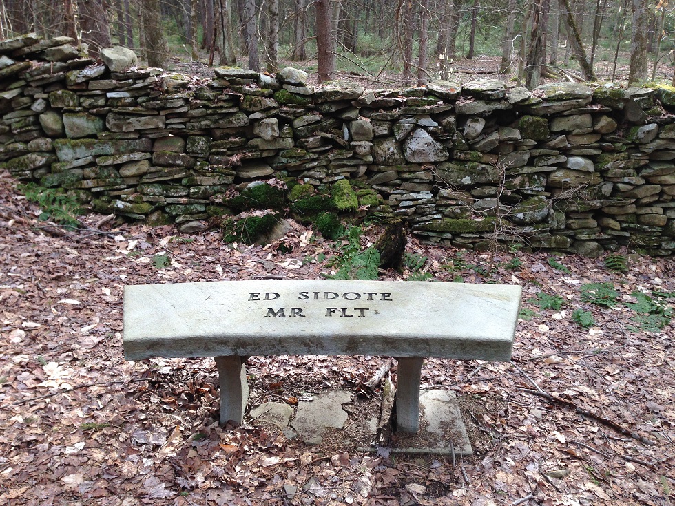
Ed Sidote Memorial Bench & old stone walls
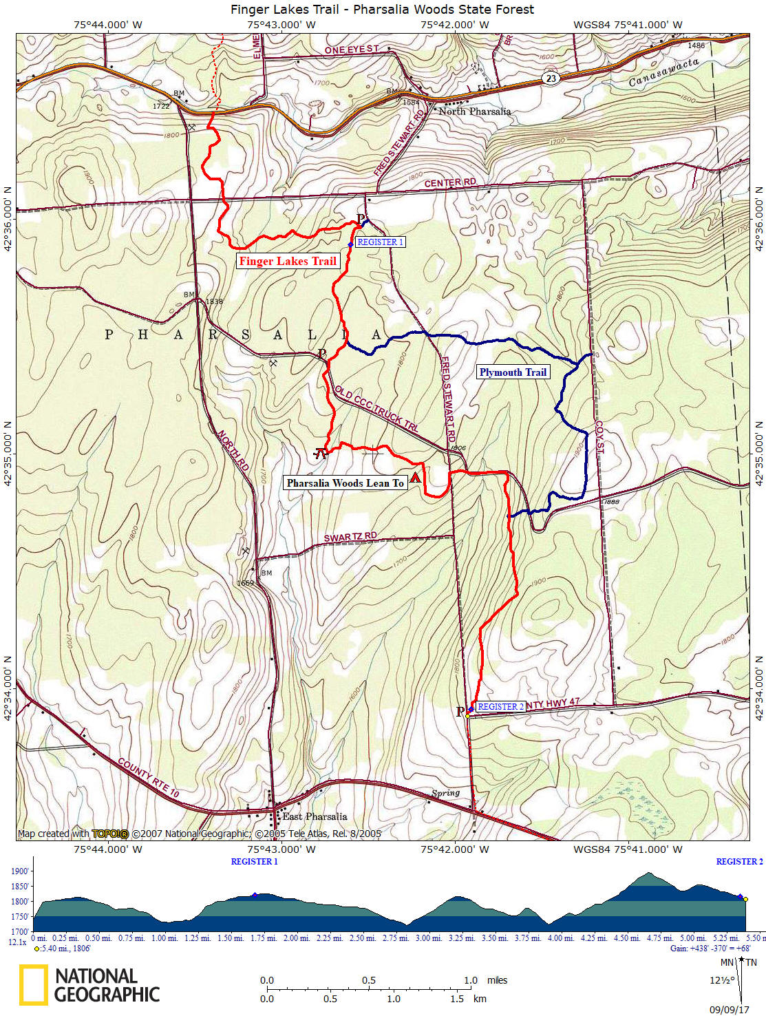
Mile Elevation Finger Lakes Trail Description (North to South) Following white blazes 0.0 1738 feet Trail crosses busy NY 23. Possible shoulder parking. GPS N42 36.458 W75 43.390
Entering Pharsalia Woods State Forest.0.6 1786 feet Cross the dirt road known as Center Street. 1.6 1816 feet Blue blazed trail on the left leads a couple of hundred feet to a parking area and camping area.
GPS coordinates N42 35.994 W75 42.5001.7 1821 feet Trail register. 2.2 1789 feet Junction of the blue blazed Plymouth Loop Trail is on your left.
2.35 1782 feet Reach dirt CCC Truck Road and turn left, following road. Shoulder parking GPS N42 35.378 W75 42.736
2.4 1781 feet Trail turns right into forest.
2.8 1720 feet Cross small stream. Picnic area. Last chance for water before the upcoming lean to. 3.4 1776 feet Ed Sidote Memorial Bench. Side trail on right travels to the Pharsalia Woods Lean To. 3.75 1778 feet Cross season dirt Fred Stewart Road.
3.8 1752 feet Reach dirt CCC Truck Road and turn right, following road. Soon pass old CCC water hole.
4.0 1755 feet Trail turns right into forest. Shoulder parking. GPS coordinates N42 34.926 W75 41.713
4.25 1790 feet Junction of the blue blazed Plymouth Loop Trail on your left.
4.65 1895 feet Highest point along FLT in Pharsalia Woods State Forest.
5.4 1806 feet Reach Fred Stewart Road and leave New Michigan State Forest. The FLT has a road walk to Tower Rd and Berry Hill Fire Tower. To continue see McDonough State Forest.
| CNY Hiking HOME PAGE | Pharsalia Woods State Forest | Finger Lakes Trail |