Pigeon Lake Wilderness
Cascade
Lake Loop
Cascade Falls
![]()
| CNY Hiking HOME PAGE | Pigeon Lake Wilderness | Adirondack Waterfalls | Moss Lake Loop |
|
Hiking in Adirondack Park Pigeon Lake Wilderness Cascade Lake Loop Cascade Falls
|
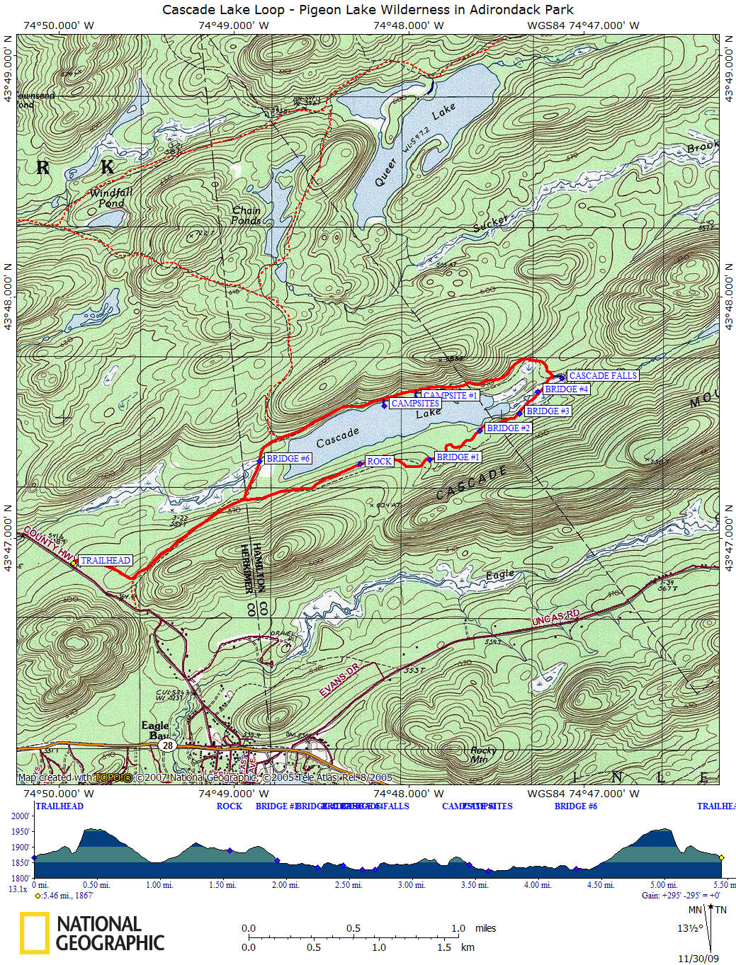
History, a 40 foot waterfall and a walk around a lake are the features of the 5.5 mile Cascade Lake Loop located in Pigeon Lakes Wilderness in Adirondack Park near Old Forge, NY. The trailhead is located on Big Moose Road north of Eagle Bay off NY 28. There is a new large trailhead with kiosk and huge parking area with kiosk further north on Big Moose Road from where the old trailhead was and still is. People still use the old trailhead. Use the new trailhead since it does have a trail register for your safety and to keep track of use of the trail.
An old girls camp called Lake Cascade Camp once graced the northern shore of the lake that was built in the 1930's and was used until the mid 1940's. If you look closely you will find remnants from the old camp. Now the area of the old camp makes for great primitive campsites along the lake.
The old road that took the campers to Camp Cascade is still used as the trail and much of this hike is along a wide path. There are bridges over the streams that need to be crossed. There are still some wet and at times muddy sections on this hike. When we hiked this on 11/29/2009, the area around bridge #2 & bridge #4 was extremely wet as well as the meadow after the falls. Although it was very muddy & wet, it is still navigational. This loop is very popular never the less.
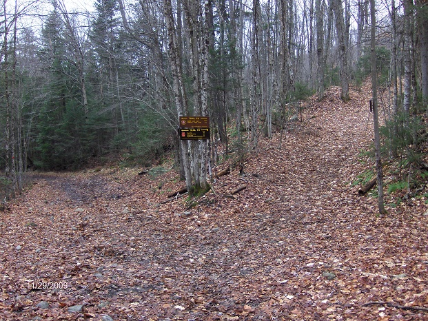
From the parking area on Big Moose Road, head to the kiosk and sign the trail register. Follow the well worn and marked trail into the woods. Following red hiking trail discs as well as yellow x-c ski discs. After 0.3 miles reach the junction with the old trail. Turn left and follow the wide old road that used to take the young campers to Camp Lake Cascade over 70 years ago.
Trail junction of the 'loop', go right here
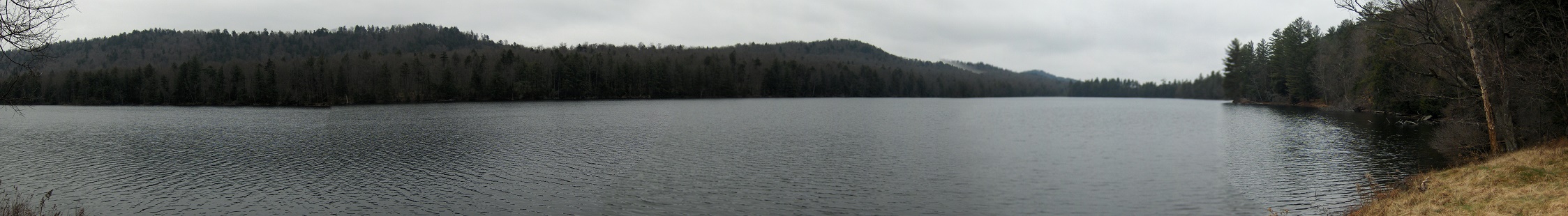
At the 0.95 mile mark of hiking, you'll pass the old county line marker for Herkimer and Hamilton County on your right. In front of you is a fork in the trail. This is the start/end of the lake loop. Take the right fork and ascend. Although you're walking along the lake, there are very limited views of the lake on the southern side of the lake. The best views of the lake are at the old camp.
After hiking 1.55 miles there is a large rock along the trail on your right. This is a great place to take a break. Over the next mile you will cross four streams on small bridges before reaching a clearing at the 2.7 mile mark. You can hear the waterfalls on your right. Take the well worn side trail to the forty foot Cascade Falls. Return back to the main trail and cross the small bridge over the stream.
After a brief time in the woods the trail enters an open area before going back into the woods. A recent trail reroute has you ascending to higher ground (following red discs) to escape a wet section before rejoining the old trail at the three mile mark. Now your hiking through young pines as the trail makes its way to its closest point to the lake during the loop (don't worry there are other opportunities to explore the lake ahead).
Soon you'll enter a clearing with old concrete ruins on your right. You are entering the old Camp Cascade. Over the next half mile look closely for the remnants of the old camp. You'll see old walls, platforms, and even an old water pipe as you walk along the old road. As you pass the clearings you can almost see the children playing from long ago. The clearings now make for great camping spots and you'll see a few of the most popular on your left. There is even a privy on your right near the main camping spots and old stone wall.
You continue to walk along the old woods road and at the 4.2 mile mark there is a trail on your right that leads 0.8 miles to the Chain Ponds Trail and onto Windfall Pond as well as Queer Lake. Soon you'll make you last stream crossing over a small bridge. Notice the old beaver dam on your left and the view on your right as you cross the bridge.
At 4.5 miles you'll close the loop around the lake as you reach the main trail junction. Continue straight to follow the same trail and then turn right off the old woods road to return back to the kiosk and parking area. Don't forget to sign yourself out at the trail register. This hike is 5.5 miles overall with a minimal elevation change of just under 300 feet.
We have detailed description, a video and a map of this hike below. You can also get the Cascade Lake Loop Hiking Guide as a pdf file for only $1 by using the buy now button above.
Mileage Elevation Trail Description 0.0 1867 feet After signing register at kiosk, follow trail into woods.
0.3 1879 feet Reach old trail. Turn left on wide old road.
0.95 1849 feet Old county marker on your right. Trail split. Take right fork and ascend.
1.55 1888 feet Big rock on your right. Great spot to take a break.
1.95 1857 feet Cross small stream on bridge #1.
2.25 1835 feet Cross small stream on bridge #2.
2.45 1840 feet Cross small stream on bridge #3.
2.6 1827 feet Cross small stream on bridge #4.
2.7 1828 feet Side trail on right leads 100 feet to Cascade Falls. Cross stream on bridge #5.
2.8 1846 feet Entering meadow.
2.9 1845 feet A trail reroute has trail ascending on your right (follow red discs).
3.0 1847 feet End of reroute. Following old trail again. Soon the trail comes very close to the lake shoreline.
3.2 1862 feet Concrete ruins on your right. Entering former Camp Cascade.
3.45 1845 feet Side trail on left leads 100 feet to campsite.
3.6 1823 feet Old wall and concrete platform on your right, then more campsites on your left.
4.2 1836 feet Junction on right of trail that leads to Windfall Pond, Chain Ponds and Queer Lake.
4.3 1830 feet Cross stream on bridge #6.
4.5 1849 feet Closing loop. Reach fork, continue straight. Old county marker on your left.
5.15 1879 feet Old trail goes straight, turn right on new trail to trailhead.
5.45 1867 feet Pass kiosk, sign out on trail register and reach parking area. End of hike.

Cascade Falls
| CNY Hiking HOME PAGE | Pigeon Lake Wilderness | The 46 ADK High Peaks | Adirondack Waterfalls |