| CNY Hiking HOME PAGE | North Carolina BRP Highlights | Blue Ridge Parkway |
|
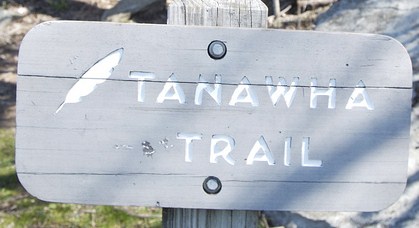
Blue Ridge Parkway Tanawha Trail Cold Prong, Rough Ridge, Linn Cove Viaduct, Wilson Creek, Grandfather Mountain, Boone Fork, Stack Rock Falls
|
The Tanawha Trail stretches 13.5 miles from Julian Price Park to Beacon Heights and runs parallel to the Blue Ridge Parkway on Grandfather Mountain in North Carolina. Tanawha, the Cherokee word for fabulous hawk or eagle, is an appropriate name for this trail that offers hikers spectacular views of distant mountains.
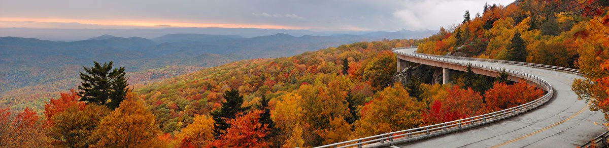
Completed at a cost of $750,000 in 1993, the Tanawha Trail, like the final section of the Parkway it mirrors, was unique in its construction. Some of the bridges were dropped into place via helicopter. The trail traverses a fragile and ancient ecosystem and leads hikers through a surprising range of biological and geological terrains. Some sections tunnel through thickets of laurel and rhododendron. Others dip down into remote hardwood coves and then ascend into evergreen glens. Boulder fields and cascading streams punctuate the landscape.
Sections above the Linn Cove Viaduct and along Rough Ridge are strenuous, but overall the trail is an easy to moderate walk. The many accesses from the Parkway let hikers choose as long a section as they like. Not many Parkway visitors hike the Tanawha Trail end to end (unfortunately). You'll need a car shuttle to complete the 13.5 mile trail, as I wouldn't attempt a 27 mile round trip hike of the Tanawha Trail. Most do a few sections of this amazing trail.
If you were to do the trail end to end, we would suggest starting from Beacon Heights and hike south to north, ending the hike at milepost 297.2 at Boone Fork Overlook. The Tanawha Trail is featured in the hiking guide book Hiking the Blue Ridge Parkway.

Tanawha Trail passing under the Linn Cove Viaduct.
Trail Highlights
From the access point below the Linn Cove Viaduct, the Tanawha Trail passes underneath the Viaduct and ascends steeply up stone steps past an enormous boulder wall. The trail levels off and enters a shady glen thick with birch and beech trees. The trail crosses Wilson Creek on a beautiful bridge and beyond the cascading water of Wilson Creek, the trail crosses a clearing filled with huge rock formations. The trail is accented with flat rocks, is like a flagstone path.
The trail then climbs sharply to Rough Ridge and over a 200 foot long boardwalk. Here there are spectacular views into the Piedmont because of the unusual low-growing and fragile mountain heather ecosystems. It also offers an outstanding glimpse of the Linn Cove Viaduct and several mountains: Grandmother Mountain, Hawksbill, and Table Mountain.
The trail continues on through a spruce and hemlock forest into a wooded glen reminiscent of the New England area. Its rocky landscape is filled with poplars, yellow birch, and oak.
Past Raven Rock, the trail tunnels through mountain laurel and rhododendron. This sheltered section then gives way to a more open area with a rock garden and large ferns cascading out of immense boulders.
More thickets of rhododendron lead to the junction of the Daniel Boone Trail, one of many trails on Grandfather Mountain, a private, commercial enterprise. Hiking or camping on Grandfather Mountain requires a permit and fee.
The Tanawha Trail passes several small cascades and crosses Boone Fork Creek on another great bridge. The trail winds in and out of rhododendron and laurel thickets, joins with an old logging road, and passes through a hardwood forest.
In the last section leading to Price Park Picnic Area, the trail breaks out of the woods into open fields. Here, it parallels and crosses Holloway Mountain Road, passes apple orchards, an old grave site, and pasture land, which in spring, is blanketed with numerous wildflowers. Finally the trail joins Boone Fork Trail for a short walk into the campground.
Tanawha Trail point to point (North to South, mileage may vary)
0.0 miles - From the Price Campground, the Tanawha Trail starts at site 46, a few hundred feet from the campground entrance. Tanawha Trail can also be accessed from Boone Fork Overlook at milepost 297.2 of the Blue Ridge Parkway. There is parking available at the overlook.
0.3 miles - Bear left, passing a connector trail that leads to the Boone Fork Trail.
0.4 miles - Boone Fork Trail. Bear left to continue on Tanawha Trail.
0.5 miles - Boone Fork Trail turns right off the Tanawha Trail.
1.6 miles - Stile, cross Halloway Mountain Road and another stile.
2.0 miles - Ascend, good view of Grandfather Mountain. Stile, meadow then wooded area.
2.2 miles - Enter field. Be alert as the trail ends up on the edge of woods.
2.4 miles - Enter wooded area.
2.55 miles - Old roadway, follow trail posts through open field, enjoying the views.
2.7 miles - Stile.
3.5 miles - Descend and cross small stream.
3.6 miles - Tanawha Trail turns right. Trail on left leads 0.2 miles to Cold Prong Pond Overlook located at milepost 299 of the Blue Ridge Parkway. Also access to Cold Prong Pond Loop Trail.
3.7 miles - Cross small stream.
3.9 miles - Cross stream on footbridge.
4.9 miles - Following an old railroad grade. Ascend gradually.
5.2 miles - Old railroad grade ends. Descend.
5.3 miles - Tanawha Trail turns right. A side trail on left leads 0.1 miles to Boone Fork Parking Area located at milepost 299.9 of the Blue Ridge Parkway.
5.4 miles - Cross Boone Fork on a really nice footbridge. Very pretty waterfalls.
5.6 miles - Trail follows an old road for 200 feet.
5.7 miles - Junction of The Grandfather Trail Extension on your right. Trails from Grandfather Mountain require a permit and fee to hike.
5.9 miles - Junction of the Daniel Boone Scout Trail on your right. Trails from Grandfather Mountain require a permit and fee to hike.
6.1 miles - Descend and cross stream then ascend over a ridge line.
7.0 miles - Cross stream on a footbridge.
7.3 miles - Cross a small stream.
7.8 miles - Limited views to the east.
8.4 miles - Tanawha trail turns right as a side trail on the left leads 0.1 mile to the Raven Rocks Overlook located at milepost 302.4 of the Blue Ridge Parkway. Tanawha Trail is now entering a New England type forest of hemlock, spruce, oak and birch.
9.15 miles - Side trail on left leads 250 feet to the Rough Ridge Parking Area located at milepost 302.8 of the Blue Ridge Parkway. Start of the most popular section of the Tanawha Trail. Soon cross a fork of Little Wilson Creek on an arching footbridge. Ascend.
9.4 miles - Reach boardwalk, soon open views. Mountain laurel and rhododendron that bloom in the early spring add to the amazing scene.
9.7 miles - Open rock outcropping for spectacular 360 degree views.
10.3 miles - Descend steeply past large boulders.
10.4 miles - Ascend around large rock outcroppings.
10.5 miles - Cross Wilson Creek on a footbridge. Side trail on left leads 0.1 miles to Wilson Creek Overlook located at milepost 303.6 of the Blue Ridge Parkway.
10.8 miles - Cross small stream. Soon a number of steep ascends and descents.
11.3 miles - Side trail on left leads 60 feet to a view over the Linn Cove Viaduct and the mountains to the east.
11.4 miles - Cross Linn Cove Branch on a wooden footbridge.
11.65 miles - Weave around boulders, descend on stone steps. Descend through a tunnel created by leaning boulders. Your level with the Viaduct and now trail descends steeply to a point where you are directly below the Linn Cove Viaduct. Trail becomes paved.
11.8 miles - Paved trail reaches north end of the Linn Cove Viaduct Visitor Center Parking Area. Walk past the visitor center and pick up trail again. The next 0.7 miles is a strenuous section of trail.
12.1 miles - Steep up and downs and then cross small stream. Soon descend steeply on 49 stone and wooden steps.
12.15 miles - Cross Stack Rock Creek with its beautiful waterfalls and cascades. Steep up and downs.
12.3 miles - Descend a wooden staircase winding around a giant rock formation. Limited views to the east. Cross small stream.
12.5 miles - a side trail on your right goes 100 feet to the Stack Rock Creek Parking Area located at milepost 304.8 of the Blue Ridge Parkway.
12.6 miles - Descend steps.
12.7 miles - Boulder field in a hemlock forest.
12.9 miles - Leave boulder field.
13.0 miles - Cross footbridge next to a stone foundation of the Parkway. Ascend an area of large boulders, then descend toward US 221.
13.2 miles - Cross US 221.
13.45 miles - Reach junction with the Beacon Heights Trail. Turn right.
13.5 miles - Reach the Beacon Heights Parking Area located at milepost 305.2 of the Blue Ridge Parkway and the southern terminus of the Tanawha Trail.

| CNY Hiking HOME PAGE | North Carolina BRP Highlights | Blue Ridge Parkway |