| CNY Hiking HOME PAGE | North Carolina BRP Highlights | Blue Ridge Parkway |
|
Blue Ridge Parkway Developed Areas Mount Pisgah Buck Springs, Frying Pan Mountain
|
In the late 1800's industrialist George Washington Vanderbilt, while building his grand Biltmore Estate in Asheville, purchased Mount Pisgah and thousands of surrounding acres for a private hunting retreat for family and friends. The nearby 16-mile Shut-In Trail (a National Recreation Trail) is part of a longer route that Vanderbilt originally created for his hunting parties.
Today the area adjoining the Parkway between milepost 407 - 412, is part of the Pisgah National Forest and is still playing host to nature enthusiasts. Mount Pisgah has the distinction of having the highest elevation of any developed area along the Parkway. Be aware of rapidly changing weather conditions.
The Mount Pisgah Recreational Area includes a campground, picnic area, an extensive trail system, and it's close by to the US Forest Service's Cradle of Forestry. Mount Pisgah Inn, at almost 5,000 feet elevation, offers views and solitude like no other place on the Parkway. This area is frequently visited by black bears and visitors should be prepared for encounters with a black bear.
The Mount Pisgah Campground is the highest and coolest campground on the Parkway. The sites are the most secluded the Parkway has to offer. The campground has 70 tent sites and 67 RV sites available for visitors. The campground fees are confusing with the NPS website stating a $16 per night fee and the recreation.gov site stating a $19 per night fee. I also saw $18 fee at another site. The campground is normally open from late May to late October.
Mount Pisgah Recreational Area Hiking Opportunities
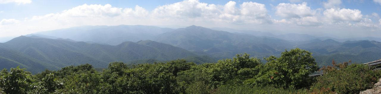
The Mount Pisgah Trail goes 1.5 miles from the Mount Pisgah Parking area to the 5721 foot summit of Mount Pisgah. This strenuous hike has an elevation gain of 712 feet. There are panoramic views from the summit (as shown above and below). This is a popular hike. Don't expect to be alone.
The trail starts at the back of the parking area behind the large sign (pic above). At the parking lot, you are just above 5,000 feet in elevation and you are in the midst of the high elevation northern hardwood forest. You will hike in this forest, dominated by oaks, all the way to the summit. You climb all the way, and the second half is the steepest with lots of rock steps to climb. It's a rocky trail, so wear good walking shoes.
At the summit, you'll find the transmission tower for WLOS-TV Channel 13 from Asheville and an observation deck. Try not to let the transmission tower ruin the wilderness feel. The view is spectacular. On a clear day, you can see the parking area, the Pisgah Inn, the Shining Rock Wilderness to your west with the famous Cold Mountain at its northern end, the Great Smoky Mountains far to the west and Asheville and Mount Mitchell to the north.
The Frying Pan Mountain Trail can be a two, four or 6.4 mile round trip hike, depending on your starting point. The longest hike starts from the picnic area. The shortest hike starts at Frying Pan Gap near milepost 409.6 on the Parkway. If you don't park at the Funnel Top Overlook at milepost 409.3, then be sure that your vehicle is completely off the Parkway at Frying Pan Gap and don't block the gated forest service road.
The United States Forest Service built the 70-foot tall tower in 1941. It is the tallest USFS lookout tower in Western North Carolina, and it is now on the National Register of Historic Places. The steel tower atop the 5,340-foot Fryingpan Mountain was built for extensive views to watch for fires until the early 1990s. Today, only hikers enjoy the views from the tower. Although the very top of the tower is locked, you can climb five flights of stairs to just underneath the top platform.
A few tall communication towers share the summit, but they only interfere slightly with the panoramic views. Many call the views from the tower even better than Mount Pisgah (see pano above). Plus its an easier hike than Pisgah with just a mile hike up to the tower. However, with an elevation gain of 410 feet, it is still a moderate to strenuous hike. The summit is 500 feet shorter than Pisgah.
The mountain received its name from neighboring Frying Pan Gap. Pioneers named the gap, but no one is sure why. One story centers on the odd shape of a spring in the gap. Another story tells of a frying pan that was always hanging in a tree in the camp.
The panoramic views include a close-up view of majestic Cold Mountain (peak is just five miles away). Mt. Pisgah is just 2.5 miles north. Looking south is Looking Glass Rock. The Great Smoky Mountains National Park is visible northwest and Shining Rock Wilderness area to the southwest.
Just walk around the gate and walk up the gravel road to the 5220 foot summit and climb Fryingpan Tower. This hike is not as popular or as famous as its neighbor, Mount Pisgah.
The Buck Spring Trail travels from the Buck Spring Overlook, located at milepost 407.7 of the Parkway, 7.3 miles to US 276. The Mountains To Sea Trail coincides with the Buck Spring Trail for most of the way, except the last mile toward US 276. The most popular section of the trail runs from Mount Pisgah Inn to the Buck Spring Overlook.
The popular 1.1 mile section is largely graded which makes for a pleasant walk from Pisgah Inn to the site of George Vanderbilt's Buck Spring Hunting Lodge. From US 271, with the exception of the first half mile, which is moderately steep, Buck Springs Trail is a gradual, sloping grade. The trail has 13 easy stream crossings while winding around 10 ridges. Many of the stream crossings have pretty cascades that are worth admiring.
Most hike this section of trail from the Pisgah Inn down to US 276, which requires a car shuttle. This trail is truly a nature lover's dream. The Mountains-to-Sea Trail overlaps Buck Springs for most of its length, but if hiking down from the Pisgah Inn, it will leave Buck Springs approximately 1 mile before reaching US 276 and drop steeply to the south. The Buck Springs Trail continues on an easy side slope to the west toward US 276.
The Shut-In Trail is a long, historic route which travels from NC 191 near Bent Creek and Asheville to the Mount Pisgah parking area. Originally the Shut-In Trail stretched from George Vanderbilt's Biltmore Estate in Asheville to his Buck Springs Hunting Lodge near Mount Pisgah. He used it to climb the Pisgah Ridge, linking his hunting lodge at Buck Springs below the summit of Mt. Pisgah to his famous Estate. Although parts were obliterated with the construction of the Parkway, parts of the trail still follow the original route.
The 16.3 mile trail is now a national recreational trail and all of the trail coincides with the Mountains To Sea Trail. The trail runs parallel with the Blue Ridge Parkway for most of its 16 miles. Though the Shut-In Trail can be used as a long-distance route, it is most frequently used for short exercise and day hikes. This is generally necessary since overnight camping is not allowed along the Parkway and 16 miles, with 3000 feet of vertical climbing, is a bit long for most day hikers. There are many convenient access points where the trail touches and crosses the Blue Ridge Parkway, mainly at overlooks.
The Shut-In Trail was named for the tunnels of rhododendron and mountain laurel through which it passes, giving the hiker a "shut in" feeling. Since you're close to the Parkway (never more than about 1/2 mile) and not far from Asheville, expect lots of hiker and jogger traffic on the trail. The Shut-In Trail does not actually start on the Parkway. At milepost 393.6 take NC 191 (Brevard Road) and you will pass the trail-head on your left just before you get to the entrance of the North Carolina Arboretum.
The strenuous Pilot Rock Trail runs 3.3 miles from Yellow Gap Road to Buck Spring Trail with a 2450 foot elevation gain. There are views on this little used trail. The summit of Little Bald Mountain is only 0.2 miles from the Buck Spring Trail. Mountain bikers use this rocky trail. Directions - driving north on US 276 from Brevard, drive 10.4 miles past the Pisgah Ranger Station and turn right on FSR 1206 (Yellow Gap Road). Drive 4.1 miles to the trailhead on the left. There's a shoulder across the road from the trail where you can park.
Laurel Mountain Trail is a 7.1 mile strenuous hike used mainly by mountain bikers. There is an elevation gain of over 2000 feet on this long trail that winds from Yellow Gap Road to the Buck Spring Trail. There limited partial views along this rocky trail. This trail along with Pilot Rock Trail, Buck Spring Trail and Yellow Gap Road would create a strenuous 15 mile loop hike.
Be sure to take the short drive east on US 276 to check out the beautiful Looking Glass Falls. Some of the above trails are featured in the hiking guide book Hiking the Blue Ridge Parkway.

| CNY Hiking HOME PAGE | North Carolina BRP Highlights | Blue Ridge Parkway |