Appalachian Trail in
New Hampshire
US 2 to NH/ME State Line
| AT in New Hampshire | Appalachian Trail | CNY Hiking Home Page |
|
|
Appalachian Trail in New Hampshire US 2 to NH/ME State Line
|
|
|
|
|
|
 |
|
|
|
|
Brief Description of Section
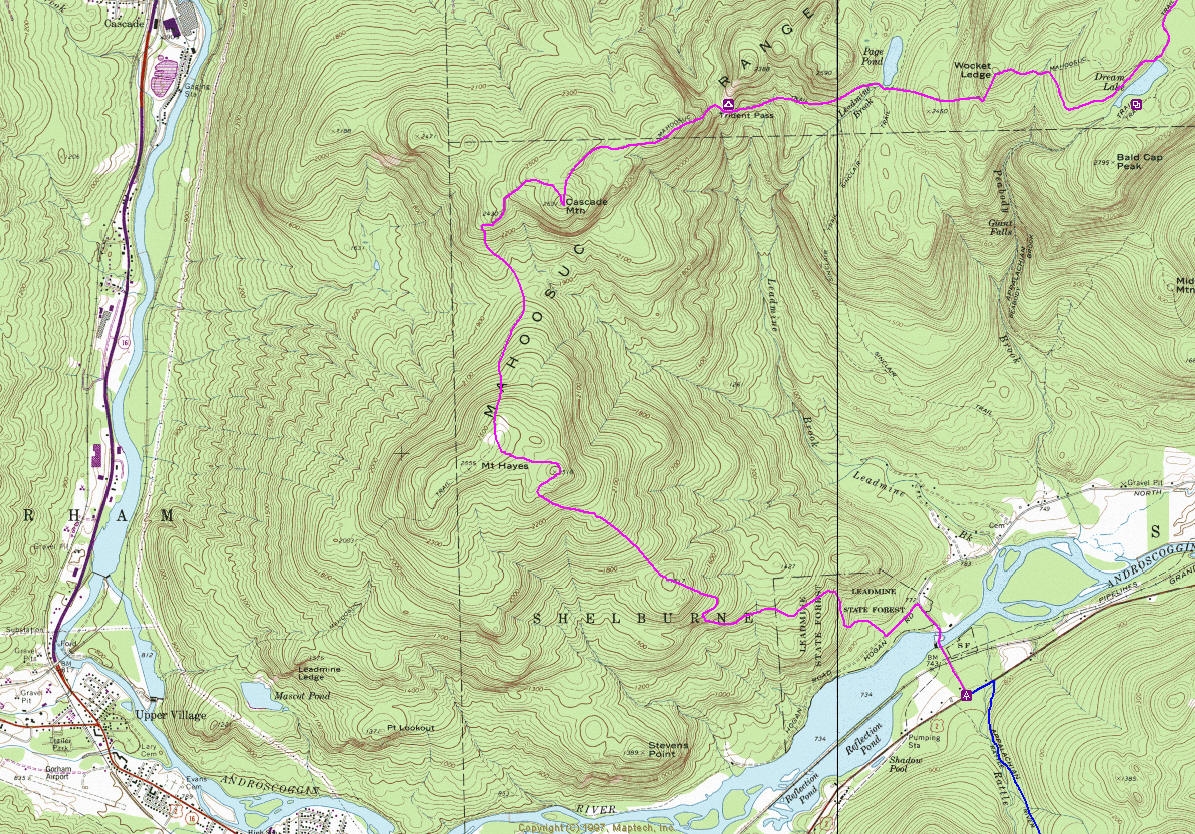
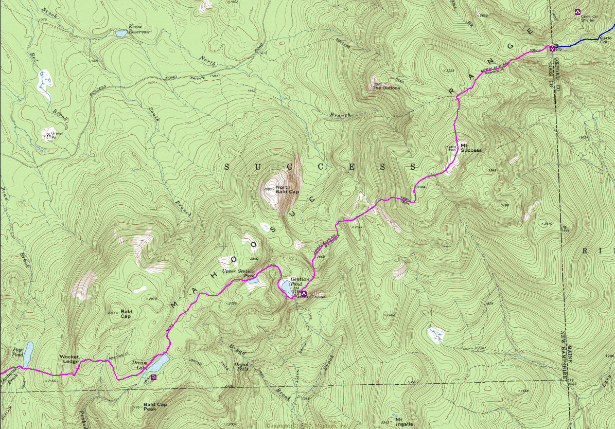
See the description of the Mahoosuc Range in the previous section. The Trail in
this section passes four scenic mountain tarns: Gentian Pond, Moss Pond, Dream
Lake, and Page Pond. The major peaks from north to south are:
Mt. Success, 3,565 feet
Cascade Mountain, 2,631 feet
Mt. Hayes, 2,555 feet (0.2 mile on side trail)
Four side trails, all maintained by AMC, intersect the A.T. From north to south,
they are:
Success Trail—intersects the A.T. 1.3 miles from the northern end of the
section.
Austin Brook Trail—intersects the A.T. 4.7 miles from the northern end of the
section.
Peabody Brook Trail—intersects the A.T. and Dryad Falls Trail 6.9 miles from the
northern end of the section.
Mahoosuc Trail—intersects the A.T. 3.9 miles from the southern end of the
section.
For a description of all trails on the range, refer to the AMC White Mountain
Guide. For current Trail information, contact the Appalachian Mountain Club.
Regulations
Throughout this section, the Trail is mostly on a corridor jointly managed by
the USFS and AMC. Camping is limited to designated sites, and off-trail camping
opportunities are limited. Do not camp in fragile alpine bogs. State fire laws
require wood and charcoal fires be built only at designated sites, and at some
sites, only camping stoves are permitted. Use dead and downed wood only.
Road Approaches
The Trail is not directly accessible by road at the northern end. It can be
reached 1.3 miles south of the Maine-New Hampshire border via the Success Trail,
which begins on gravel Success Pond Road, 8.7 miles from Berlin, New Hampshire.
The road is a Crown Vantage Company Road, open to public use but accessible only
from Berlin and sometimes difficult to find. (Leave NH 16 just south of Berlin,
4.5 miles north of the eastern junction of U.S. 2 and NH 16 in Gorham, and cross
the Androscoggin on the Cleveland Bridge. At the eastern end of the bridge, the
road—Unity Street—swings left and passes through traffic lights in 0.7 mile from
NH 16. At 0.8 mile, the road bears right across railroad tracks and becomes
Hutchins Street. It turns sharply left at 1.6 miles, at Franks Village Store and
continues past the Crown Vantage mill yard. At 1.9 miles, where there has
usually been a large sign that reads “OHRV P 1 M,” Success Pond Road begins on
the right, east. Watch for trucks entering from the right. The first part of the
road may be difficult to distinguish from branch roads, but, once out of the
open area, it is well-defined.)
At the southern end of the section, the Trail crosses U.S. 2, 3.6 miles east of
Gorham. Parking is available 0.8 mile north of U.S. 2 on Hogan Road, where the
Trail turns right into the woods on the Centennial Trail, or at the junction of
Hogan and North roads.
Shelters and Campsites
This section has one campsite with shelter and one tentsite:
Gentian Pond Campsite: Shelter rebuilt in 1974 and maintained by AMC; 4.7 miles
from northern end of section; accommodates 14; 4 tent platforms; water available
from brook 500 feet north of shelter.
Next shelter or campsite: north 5.2 miles (Carlo Col Shelter); south 4.9 miles.
Trident Col Tentsite: Primitive site rebuilt in 1978 and maintained by AMC; 9.6
miles from northern end of section on short side trail; accommodates 8; tent
platforms only; water available from spring (sometimes unreliable), 500 feet
west of tentsite.
Next shelter or campsite: north 4.9 miles (Gentian Pond Campsite); south 8.8
miles (Rattle River Shelter).
In addition to those sites, Carlo Col Shelter is a half-mile north of the
Maine-New Hampshire border, 0.3 mile down the Carlo Col Trail.
Supplies, Services, and Accommodations
The nearest supply point is Gorham, New Hampshire (ZIP Code 03581, telephone,
supermarket, laundromat, restaurants, bus stop, equipment), 3.6 miles west of
the southern end of the section. Supplies are also available in Berlin (11.7
miles; 3.0 miles on Success Trail to Success Pond Road, then 8.7 miles to the
end of Success Pond Road.
From the Trail crossing of U.S. 2 camping is available, and it is 2.0 miles west
to a restaurant .
In an emergency, call the New Hampshire State Police, (603) 846-5517 or (603)
846-3333, or AMC Pinkham Notch Visitor Center, (603) 466-2721.
Gorham, 3.6 miles west on U.S. 2 from the southern end of the section has a
number of motels, hostels, a guest house (inexpensive), and camping, as does
Berlin, at the end of the Success Pond Road. Tourist cabins and a camping area
are available on U.S. 2, 2.0 miles west of the Trail crossing.
Trail Description, North to South
Miles Data
0.0 Section begins at Maine-New Hampshire state line (2,972 feet). The boundary
is designated by yellow blazes along a cleared strip. Descend southwest to rough
col, and ascend along flank of unnamed 3,335-foot peak north of Mt. Success.
1.3 Reach junction. (Success Trail descends right, 3.0 miles, to Success Pond
Road.) Ascend northern ridge of Mt. Success.
1.9 Reach summit of Mt. Success (3,565 feet). Descend southwest to ledges of
lower peak of Mt. Success, and enter woods.
3.3 Cross brook in col. Climb southwest over two humps, then to ridgetop. Drop
generally south down ridge and through spruce grove.
4.7 Reach Gentian Pond Campsite on left (2,166 feet). (Austin Brook Trail
descends left 3.3 miles to North Road in Shelburne.) Water is available from a
small inlet brook at the northeastern side of pond; follow a path 300 yards
northeast from shelter. Beyond shelter, follow southwest side of Gentian Pond,
pass around northwest corner of pond, and climb steeply.
5.4 Pass along northwestern shore of Moss Pond. Ascend northwest and west, then
descend through swampy woodland. Cross inlet brook of Dream Lake, and briefly
follow lumber road.
6.9 Reach junction. (Peabody Brook Trail leads left, passes Dryad Falls Trail in
100 yards, and descends 3.1 miles to North Road. Dryad Falls Trail descends past
a series of cascades to North Road.) Just beyond junction, recross inlet brook
of Dream Lake, and continue around lake’s northern end. Climb around end of
small ridge, descend to cross upper (west) branch of Peabody Brook, and then
climb west.
8.0 Reach Wocket Ledge, a spur of Bald Cap. (Side trail leads northwest 50 feet
to ledges.) Descend steeply southwest, then gradually west.
8.6 Pass to south of Page Pond and cross outlet on beaver dam. Descend west over
southern flank of peak west of Page Pond. Continue traversing side of two
additional peaks. These three peaks form the trident. Climb briefly northwest.
9.6 Reach Trident Col. Trident Col Tentsite is 175 yards to right on side trail.
Water is available from spring 50 yards west of campsite. A.T. climbs steeply
southwest beside ledges to eastern peak of Cascade Mountain, continuing west and
southwest, rising gradually.
10.7 Reach summit of Cascade Mountain (2,631 feet). Veer sharply northwest back
into woods, and then descend the southwest ridge of Cascade Mountain. Pass
through col between Cascade Mountain and Mt. Hayes. (Water is just east of
Trail.) Climb northern ridge of Mt. Hayes.
12.6 A.T. diverges left from Mahoosuc Trail to follow Centennial Trail
(constructed in 1976, AMC’s centennial year). (Mahoosuc Trail continues straight
ahead 0.2 mile to summit of Mt. Hayes, 2,555 feet, then descends 3.1 miles to NH
16, 1.3 miles north of Gorham.) Descend southeast on Centennial Trail over
series of open ledges, and then climb slightly.
12.9 Reach eastern summit of Mt. Hayes on open ledges with views of Carter-Moriah
Range and northern Presidentials. Descend southeast to small valley, then climb
briefly. Resume descent, and cross a logging road.
15.0 Cross brook (reliable water). Continue on woods road. Soon, turn right off
woods road. Descend gradually, then more steeply on stone steps. Join woods
road, and follow right.
15.7 Turn left onto gravel Hogan Road at lower end of Centennial Trail.
16.0 Turn right onto paved North Road.
16.2 Cross Androscoggin River on Leadmine Bridge with small dam and power plant
on right. Cross railroad tracks.
16.5 Reach section end at U.S. 2, 3.6 miles east of Gorham (760 feet). To
continue on Trail, turn left, cross Rattle River on highway bridge, and then
turn right onto Rattle River Trail (see New Hampshire Section Two).
Trail Description, South to North
Miles Data
0.0 From U.S. 2, 3.6 miles east of Gorham (760 feet), take North Road to the
north. Soon, cross railroad tracks.
0.3 Cross Androscoggin River on Leadmine Bridge, with small dam and power plant
on left.
0.5 Turn left from North Road onto gravel Hogan Road.
0.8 Turn right onto woods road, beginning of Centennial Trail, opposite clearing
and parking area. (Trail was constructed in 1976, AMC’s centennial year.) A.T.
turns left off woods road in 50 yards, heads northwest, and climbs steeply on
stone steps, then more gradually. Turn left onto a woods road.
1.5 Cross small brook (reliable water). Cross logging road. Climb, then turn
sharply left; ascend moderately to open ledges.
3.6 Reach eastern summit of Mt. Hayes with views of Carter-Moriah Range and
northern Presidentials. Continue across open ledges.
3.9 Reach junction with Mahoosuc Trail to left. Mt. Hayes (2,555 feet), is 0.2
mile left on this trail, with NH 16 (1.3 miles north of Gorham) 3.1 miles
beyond. Bear right, and descend north to col between Mt. Hayes and Cascade
Mountain. (Water may be found in col just east, to right of Trail.) Beyond col,
climb Cascade Mountain by southwest ridge.
5.8 Reach summit of Cascade Mountain (2,631 feet). Veer sharply left back into
woods, heading northeast and east. Cross eastern peak of Cascade Mountain, then
descend steeply to northeast and east.
6.9 Reach Trident Col. Trident Col Tentsite is 175 yards left on side trail,
with water from spring 50 yards west. About 0.3 mile beyond col, briefly follow
old logging road. Turn left (southeast), and descend, traversing ridge past
three peaks that form Trident. Beyond Trident, continue east, cross three
gullies (possible water), and begin ascent.
7.9 Pass to south of Page Pond, and cross outlet on beaver dam. Climb gradually
east, then steeply northeast.
8.5 Reach Wocket Ledge, a spur of Bald Cap. (Side trail leads northwest 50 feet
to ledges.) Descend steeply southwest, then gradually west. Descend east, cross
upper (left) branch of Peabody Brook, climb around end of small ridge, and then
gradually descend to Dream Lake. Bear left, continuing around northern end of
lake.
9.6 Cross inlet brook of Dream Lake. Just beyond, reach junction. (Peabody Brook
Trail descends right, passing Dryad Falls Trail in 100 yards, 3.1 miles to North
Road. Dryad Falls Trail descends right past series of scenic cascades to North
Road.) From Dream Lake, A.T. follows old lumber road 100 yards, recrosses inlet
brook, and continues northeast through sometimes swampy woodland, ascending
initially, then descending.
11.1 Reach Moss Pond, and follow northwestern shore. About 0.3 mile past pond,
turn abruptly right, and descend to Gentian Pond. Pass along southwestern shore
of pond.
11.8 Reach Gentian Pond Campsite (2,166 feet) on the right. Water is available
at small brook at northeastern side of pond, reached by side path 300 yards
northeast from the shelter. (Austin Brook Trail descends right 3.3 miles to
North Road in Shelburne.) Beyond shelter, A.T. ascends through spruce grove to
ridge, crosses small col, then climbs over two steep humps.
13.2 Cross small brook in col after second hump. Ascend steeply northeast, leave
woods, and head onto open ledges.
14.6 Reach summit of Mt. Success (3,565 feet), and descend north to col.
15.2 Reach junction. (Success Trail descends left 3.0 miles to Success Pond
Road.) Climb northwest along the flank of unnamed 3,335-foot peak north of Mt.
Success. Pass through col, and continue northwest.
16.5 Reach Maine-New Hampshire state line (2,972 feet), where section ends.
Border is marked by yellow blazes along cleared strip. From this point, A.T.
continues north on Mahoosuc Trail.
 |
|
| AT in New Hampshire | Appalachian Trail | CNY Hiking Home Page |
![]()