This 7.2 mile section of the Appalachian Trail
finishes the journey in Great Smoky Mountains National Park for north bound thru
hikers. For south bound hikers, it's the start of the long journey through
the park. The main feature of this stretch of trail is the fire tower on
Mount Cammerer.
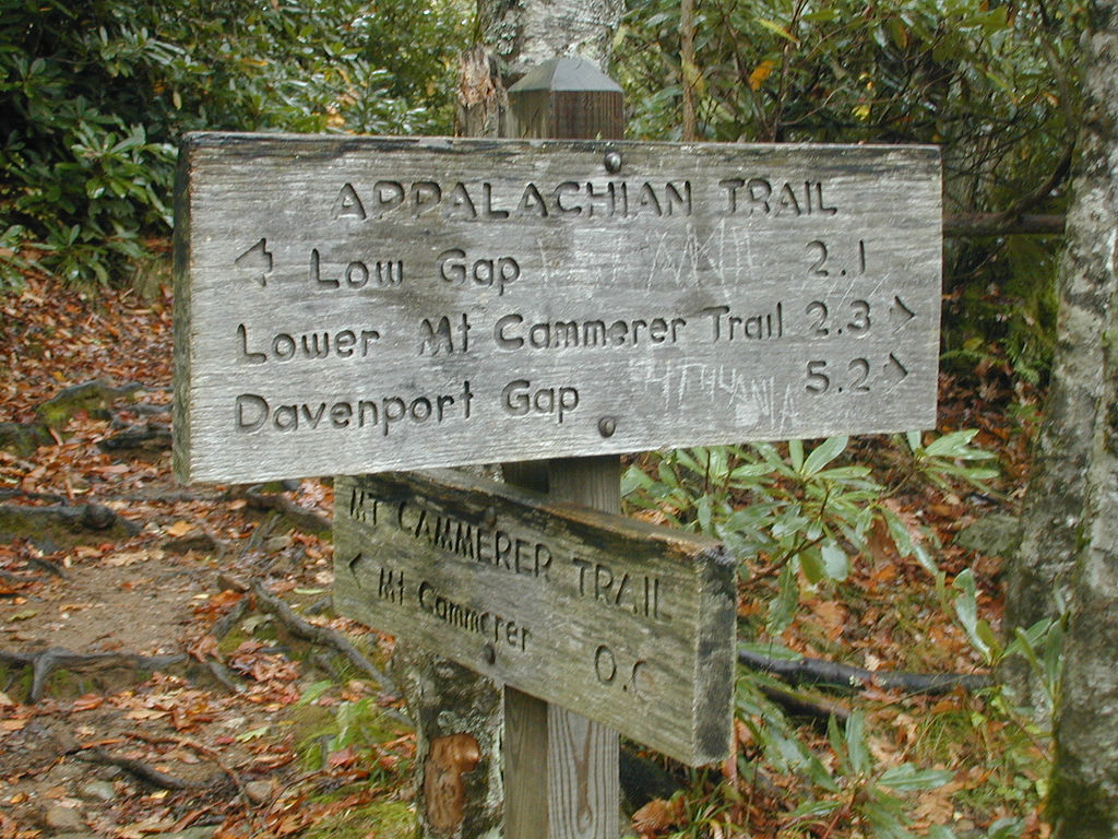
This section of the AT begins at Low Gap at the
junction of the Low Gap Trail. Taking the Low Gap Trail north will bring
you to Cosby Campground in 2.5 miles. The trail heading south will lead to
the Big Creek Trail in 2.5 miles.
Junction of Mount Cammerer Trail

Mount Cammerer Fire Tower
After 2.1 miles of hiking reach a side trail that
leads 0.6 miles to the Mount Cammerer Fire Tower. This historic stone and
wood structure was originally built by the CCC in 1939. The structure was
rebuilt in 1994. There are panoramic views from the platform.
The AT now begins a long gradual descent toward
Davenport Gap. At 6.2 miles the trail reaches the Davenport Gap Shelter.
This shelter was named for William Davenport, who surveyed the state line in
1821. The shelter is sometimes referred as the Smokies Sheraton. The
shelter was originally built in 1961 and renovated in 1998. It sleeps
twelve and has no privy.

Davenport Gap Shelter aka Smokies Sheraton
At 7.2 miles reach TN 32/NC 284 and Davenport
Gap, which marks an end to this section as well as the AT section in Great Smoky
Mountains National Park. The trail now leaves the park and winds its way
toward the Pigeon River and I-40.

View from the trail near Davenport Gap
Shelter
We offer the full GPS tracks of the 72 mile section
of the Appalachian Trail in Great Smoky Mountain National Park for only $1.97 via a .gpx
file. This file also includes waypoints for the shelters located
along the trail as well as parking areas. A great tool to keep
you on the trail or to make your own maps!
We recommend purchasing any of the following books for those
looking for more information on hiking the Appalachian Trail in Great Smoky
Mountain National Park:
Appalachian Trail Guide to Tennessee-North Carolina: 13th Edition
Exploring the Appalachian Trail: Georgia North Carolina Tennessee
Hiking Great Smoky Mountains National Park
Best Easy Day Hikes Great Smoky Mountains National Park
Hiking Trails of the Smokies
Trails Illustrated Great Smoky Mountains National Park
Trails Illustrated Great Smoky Mountains National Park Explorer