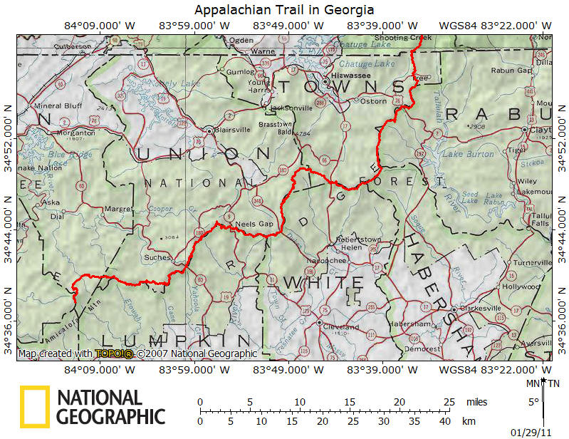
The Appalachian Trail travels 78.5 miles in
Georgia. It all starts or ends on the Appalachian Trail at Springer
Mountain, the southern terminus of the trail. Some may find it surprising
that the AT never falls under 2500 feet in elevation in Georgia with a high
point of 4461 feet at Blood Mountain.
Blood Mountain is the most visited spot along the
Appalachian Trail south of Clingmans Dome and the 40,000 visitors per year has
taken its toll on the area as well as the shelter located near the summit.
The trail in Georgia features many steep up and downs and those trying to get an
early spring start could find cold rain, sleet or snow in these higher
elevations in the southern Appalachians. To reach the southern terminus of the Appalachian
Trail on the 3782 foot summit of Springer Mountain, you have three options.
The first and most popular is to begin at the visitor center at Amicalola Falls
State Park and take the 8.8 mile Approach Trail to Springer Mountain. This
trail is steep at times and climbs almost the whole way with an elevation gain
of over 2000 feet.
Another option is to take USFS 28 to Nimblewill
Gap and then take the Approach Trail another 2.8 miles to the summit of Springer
Mountain. This option requires driving on some rough and at times, muddy
forest service roads. The quickest and easiest way to get to the
southern terminus at Springer Mountain is to take USFS 42 to the crossing of the
Appalachian Trail about one mile north of the summit. This will mean
retracing your steps, however it will save you many miles compared to hiking the Approach
Trail. USFS 42 is a well graded gravel road that is suitable for all
vehicles.
It all starts at Springer Mountain and as you
hike north you'll find other memorable places along the Appalachian Trail in
Georgia including Long Creek Falls, Sassafras Mountain, Justus Mountain, Ramrock
Mountain, Big Cedar Mountain, Blood Mountain, Levelland Mountain, Wolf Laurel
Top, Cowrock Mountain, Wildcat Mountain, Poor Mountain, Sheep Rock Top, Blue
Mountain, Rocky Mountain, Cheese Factory Site, Tray Mountain, Kelly Knob, and
Powell Mountain.
Use the links above to explore different sections
of the trail and look below for a detailed description of major points of the
Appalachian Trail in Georgia. We
suggest checking out
Appalachian Trail Guide to North Carolina-Georgia and
Appalachian Trail, Springer Mountain to Davenport Gap (National Geographic Trails Illustrated Map) to help plan your Appalachian
Trail adventure.
to help plan your Appalachian
Trail adventure.
|
Appalachian Trail GPS Tracks $1.97 Get
the complete GPS Tracks for the AT in Georgia for ONLY $1.97!
This .gpx file includes waypoints for all trail shelters along the trail in
Georgia and many of the official AT parking areas. Use the BUY NOW button
below and we'll send you the file via e-mail! Happy Hiking!
NOTE: Some trail
relocation may have occurred, which may not be reflected with our GPS
Tracks. The tracks are very close to the current trail.
|
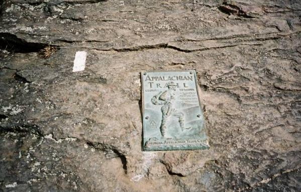
First blaze and plaque on Springer Mountain
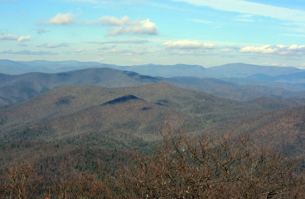
View from Tray Mountain
| Miles
from Springer Mtn |
Elevation |
Key points along the
Appalachian Trail in Georgia (South to North) |
| 0.0 |
3782 feet |
First white blaze & plaque on
Springer Mountain |
| 0.2 |
3730
feet |
Springer Mountain Shelter |
| 1.0 |
3350 feet |
USFS 42 |
| 2.8 |
2870
feet |
Stover Creek Shelter |
| 3.8 |
2660 feet |
Stover Creek |
| 4.3 |
2530 feet |
Three Forks, USFS 58 |
| 5.2 |
2800 feet |
Trail to Long Creek Falls |
| 6.2 |
3000 feet |
USFS 251 |
| 8.1 |
3200
feet |
Hawk Mountain Shelter |
| 8.6 |
2854 feet |
Hightower Gap, USFS 42/69 |
| 10.5 |
2673 feet |
Horse Gap |
| 12.2 |
2800 feet |
Cooper Gap, USFS 42/80 |
| 12.9 |
3224 feet |
Justus Mountain |
| 14.3 |
2550 feet |
Justus Creek |
| 15.8 |
3000
feet |
Gooch Mountain Shelter |
| 17.3 |
2821 feet |
Gooch Gap, USFS 42 |
| 19.6 |
3260 feet |
Ramrock Mountain |
| 21.1 |
3173 feet |
Woody Gap, GA 60 (Suches, GA 30572) |
| 22.1 |
3737 feet |
Big Cedar Mountain |
| 23.4 |
3300 feet |
Dan Gap |
| 24.3 |
3050 feet |
Lance Creek |
| 26.2 |
3480 feet |
Burnett Field Mountain |
| 26.7 |
3250 feet |
Jarrard Gap |
| 28.1 |
3650
feet |
Bird Gap, Wood Hole Shelter,
Freeman Trail |
| 28.5 |
3800 feet |
Slaughter Creek Campsite |
| 29.3 |
4450
feet |
Blood Mountain, Blood
Mountain Shelter. Highest point in Georgia along the
AT. |
| 30.7 |
3450 feet |
Flatrock Gap, Trail to Byron Reese
Memorial |
| 31.7 |
3125 feet |
Neel Gap, US 19/129 |
| 32.8 |
3690 feet |
Bull Gap |
| 33.2 |
3942 feet |
Levelland Mountain |
| 33.9 |
3470 feet |
Swaim Gap |
| 34.7 |
3520 feet |
Rock Spring Top |
| 35.4 |
3766 feet |
Wolf Laurel Top |
| 35.9 |
3800 feet |
Baggs Creek Gap |
| 36.7 |
3842 feet |
Cowrock Mountain |
| 37.7 |
3138 feet |
Tesnatee Gap, GA 348 |
| 38.4 |
3370
feet |
Whitley Gap Shelter |
| 38.6 |
3450 feet |
Hogpen Gap, GA 348 |
| 39.5 |
3470 feet |
White Oak Stamp |
| 40.6 |
3620 feet |
Poor Mountain |
| 42.4 |
3600 feet |
Sheep Rock Top |
| 43.2 |
3050
feet |
Low Gap Shelter |
| 44.6 |
2990 feet |
Poplar Stamp Gap |
| 47.0 |
3300 feet |
Cold Springs Gap |
| 48.2 |
3500 feet |
Chattahoochee Gap |
| 48.9 |
3485 feet |
Red Clay Gap |
| 49.6 |
3600 feet |
Campsite |
| 49.8 |
3500 feet |
Spring |
| 50.5 |
3900
feet |
Blue Mountain Shelter |
| 51.4 |
4025 feet |
Blue Mountain |
| 52.9 |
2949 feet |
Unicoi Gap, GA 75 (Helen, GA 30545) |
| 53.5 |
3300 feet |
Stream |
| 54.3 |
4017 feet |
Rocky Mountain |
| 55.6 |
3113 feet |
Indian Grave Gap, USFS 283 |
| 56.3 |
3580 feet |
Tray Mountain Road aka USFS 79 |
| 56.6 |
3590 feet |
Cheese Factory site |
| 57.3 |
3847 feet |
Tray Mountain Road aka USFS 79 |
| 58.1 |
4430 feet |
Tray Mountain |
| 58.6 |
4200
feet |
Tray Mountain Shelter |
| 62.2 |
3400 feet |
Swag of the Blue Ridge |
| 63.3 |
3500 feet |
Sassafras Gap |
| 64.2 |
3304 feet |
Addis Gap |
| 65.2 |
4276 feet |
Kelly Knob |
| 66.0 |
3550
feet |
Deep Gap Shelter |
| 67.2 |
3650 feet |
McClure Gap |
| 67.4 |
3850 feet |
Powell Mountain |
| 68.4 |
3200 feet |
Moreland Gap |
| 69.0 |
2650 feet |
Streams |
| 69.6 |
2675 feet |
Dicks Creek Gap, US 76 (Hiawassee,
GA 30546) |
| 70.7 |
3150 feet |
Campsite |
| 71.4 |
2900 feet |
Cowart Gap |
| 72.9 |
3550 feet |
Bull Gap |
| 74.1 |
3050
feet |
Plumorchard Gap Shelter |
| 74.8 |
3460 feet |
As Knob |
| 75.4 |
3020 feet |
Blue Ridge Gap |
| 76.4 |
3500 feet |
Campsite |
| 76.6 |
3390 feet |
Rich Cove Gap |
| 78.5 |
3825 feet |
GA-NC State Line |