Our 2010 Hikes
April 7
Hoxie Gorge &
Underwood Hill
![]()
| CNY Hiking HOME PAGE | Our 2010 Hikes | Hiking in Cortland County | FLT/NCT - Hoxie Gorge/Underwood Hill |
|
Our 2010 Hikes April 7 Hoxie Gorge & Underwood Hill
|
Date: April 7, 2010
Length of hike: 8.8 miles
Location: near McGraw, NY
Trailhead: Hoxie Gorge Road at FLT sign near NCT kiosk
Trailhead Coordinates: N42 32.841 W76 04.807
Name of Trails: Finger Lakes Trail / North Country Trail, Hunting Bypass Trail and McDermott Nature Trail
Hike Difficulty: Moderate to Strenuous
Elevation Gain: 1108 feet
Trail Conditions: Some wet and muddy spots plus blow downs.
Features: Hoxie Gorge, scenic streams, Underwood Hill, panoramic views
Our hike on Wednesday featured a scenic 4.7 mile section of the Finger Lakes Trail / North Country Trail. This part of the trail travels by as well as into scenic Hoxie Gorge. This gorge may not be as spectacular as the amazing gorges in the Ithaca/Watkins Glen area, however it is still a beautiful area. If you like walks along scenic streams and panoramic views, then you'll love this hike (or at least part of it). We also visited Hoxie Gorge Lean To.
The other main feature of this hike are the panoramic views from Underwood Hill. Much of this hike is on PRIVATE PROPERTY (be sure to stay on the trail). There is a section that is CLOSED for hunting from 10/1 to 12/31. Our hike took us a total of 8.8 miles with a total elevation gain of just over 1100 feet. You don't have to hike what we did, but I would recommend hiking to at least the picnic table on Underwood Hill and back for a shorter 5.2 mile hike (or 5.5 miles if you visit the lean to also).
Kiosk and FLT sign on Hoxie Gorge Road
We started our hike from the North Country Trail Kiosk on Hoxie Gorge Road, just past the end of the maintained road. We parked along the side of the seasonal road. There is a parking area further up the road at the main starting point of the McDermott Nature Trail. This property is owned by SUNY @ Cortland.
From the kiosk, follow the white blazes of the Finger Lakes Trail / North Country Trail (FLT/NCT). This first part was wet and muddy at certain points. At 0.1 miles reach a junction of a blue blazed trail on your left. This trail leads to the nature trail and the parking area. Continue on the FLT/NCT and soon the trail briefly follows the McDermott Nature Trail before turning right off the nature trail at 0.35 miles and descending into the gorge.
Hoxie Gorge Creek
You'll cross Hoxie Gorge Creek twice before ascending back out of the gorge. There is a nice "pool" area of the creek that the trail passes by just prior to leaving the creek. The trail eventually reaches an old wagon road, near an old culvert using rock steps. After crossing the old wagon road, the trail travels through a camping area. After climbing out of the bivouac area, we decided to find the lean to (no marked trail). We did see a couple pieces of colored tape, but followed our gps to reach the Hoxie Gorge Lean To at one mile of hiking. This side trip was about 0.15 mile from the main trail. There is no marked path to the lean to, which is located at N42 32.780 W76 04.346 for those with a gps.
Hoxie Gorge Lean To
After a break, we made our way back to the white blazes of the main FLT/NCT to continue our hike. The trail crosses and/or follows numerous different scenic streams. Or you may find yourself up above looking down into a ravine. The trail is scenic and pleasant as you make your way through the Hoxie Gorge State Forest section of this hike. After leaving the state land, the trail descends toward the banks of another beautiful stream. You may notice a home made bench on your right at 1.9 miles as you leave this nice area.
The trail reaches a partially open area with numerous old large cut trees on your left. Prior to reaching an open field on a farm lane, the trail turns left passing old farm equipment as you hike along the edge of a field. At 2.5 miles there is an opening with a pretty nice view to your right. The trail soon comes into the edge of the open field at 2.6 miles and reach the junction of the orange blazed Hunting Bypass Trail at 2.7 miles. The FLTC maps say its a blue blazed trail. The blazes have been changed to orange. Turn left here into the open field (CLOSED 10/1-12/31). At 2.9 miles reach a picnic table in the middle of this open field with panoramic views. A perfect place to take a break. Windy place at times! It is wide open here.
Picnic Table with a view
You are on Underwood Hill, although you may think for a moment that you've been beamed to one of the balds of North Carolina. Maybe Max Patch along the Appalachian Trail? For those who are looking for a shorter hike, this is the perfect stopping and turn around point. There are a few other views further, but nothing like the views that are in front of you at the picnic table. Bring your lunch, but remember to carry out what you carry in. You are on PRIVATE PROPERTY.
Scrappy on Underwood Hill
We continued on to the edge of the field. There were no blazes as we reached the edge of the field. Nothing to tell us which way to go. We had a FLTC map plus their GPS tracks loaded on my gps, so I knew we had to turn left. As we rounded the corner and continued to follow the edge of the field, the white blazes did start again. The trail eventually enters the woods at 3.2 miles. This part of the trail can be hard to follow at times, plus there are numerous blow downs.
Before you know it your out of the woods and back into an open field with some views. Soon the trail follows a small stream as you descend back into the woods at 3.55 miles. More blow downs as the trail follows the open fields inside the woods. As you cross an opening there are views to your left before the trail reenters the woods and passes a hunters blind with a view of the huge field you just skirted in the woods.
There is another hunting platform near a pond on the left of the trail as you ascend toward a trail register and the highest point (1827 feet) of this hike at 4.7 miles. The trail now descends toward Underwood Hill Road, reaching the road at five miles. We turned right and followed the road. There are a couple of dogs along the road that barked but did not bother us. At 5.8 miles reach Stone Road and turn right, passing the Stone Road Farm.
View from the Hunting Bypass Trail
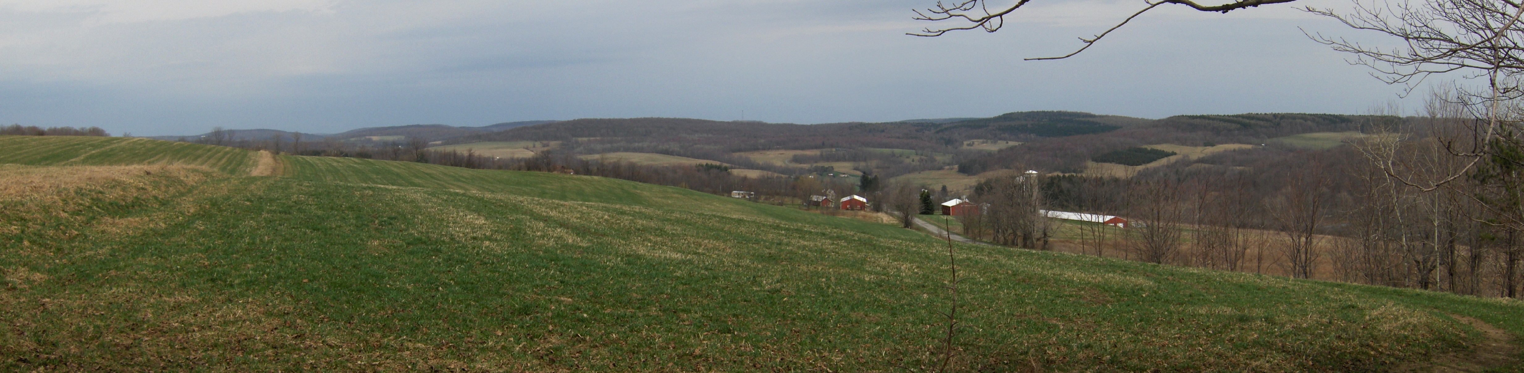
At 6.25 miles we reached the Hunting Bypass Trail and a familiar yellow FLT sign on a telephone pole. There were a couple of blue blazes left over, but then the trail was marked with orange blazes. As we hiked on the bypass trail making our way to the main FLT/NCT, there was an opening with a nice view (see panorama above). At 6.45 miles reach the main FLT/NCT. From here retrace your steps, except at the old culvert/wagon road at 8.3 miles, turn right and follow the McDermott Nature Trail. Reach the blue blazed trail at 8.7 miles. Turn left and almost immediately reach the main FLT/NCT. Continue straight past the kiosk and back to your vehicle for a 8.8 mile hike.
Directions: From Cortland, US 11 south to Hoxie Gorge Road. Take road all the way to just past the start of the seasonal part of road. You'll see the green FLT sign and NCT kiosk. There is room to park along the side of the road. There is a parking area further up the seasonal road.

| CNY Hiking HOME PAGE | Our 2010 Hikes | Hiking in Cortland County | FLT/NCT - Hoxie Gorge/Underwood Hill |
contact CNY HIKING by email at contact@cnyhiking.com
(c) 2006-today CNY Hiking - All rights reserved. Any use of information from this site without permission is strictly forbidden.


