East-Central Adirondacks
Pharaoh Lake
Wilderness
![]()
| CNY Hiking HOME PAGE | Pharaoh Mountain | East-Central Adirondacks |
|
Hiking in Adirondack Park East-Central Adirondacks Pharaoh Lake Wilderness
|

The 46,283 acre Pharaoh Lake Wilderness is located in Warren and Essex Counties in the towns of Schroon, Ticonderoga, Horicon and Hague. The wilderness is located east of US 9 and I-87, south of NY 74, north of NY 8 and west of NY 9N. There are over 60 miles of hiking trails and fourteen lean to's located in the wilderness, making this a very popular destination for outdoor adventurers. This is easily the most popular recreational area in the East-Central Adirondacks.
With all the hiking trails you can create a loop that fits your schedule, whether a day hike or a backpacking trip. You can also use Putnam Pond State Campground as a base for your adventure. We would suggest the Putnam Pond Loop for those camping at Putnam Pond State Campground. The most popular hikes include Pharaoh Mountain, Treadway Mountain, Goose Pond, Crab Pond, Rock Pond, Gull Pond, Pharaoh Lake, Clear Pond, Grizzle Ocean and Berrymill Pond to name just a few. It's a large area to explore, so expect to take more than just a few days to see it all.
We'd recommend a hike to Treadway Mountain. It's a long 3.9 mile one way hike from Putnam Pond Campground with an elevation change of nearly 900 feet. You are rewarded with spectacular views from it's rocky summit. It's a mountain that gets overlooked and deserves more attention. If you take a kayak one mile across Putnam Pond, the hike to the summit from the landing is only 2.3 miles one way.
Look below for some info on the many trails in this wilderness as well as a map and some pictures. You can get more info on hiking in this area with trail maps of the Adirondacks from Adirondack Park Bundle- Trails Illustrated Map
. Read about a hike in this wilderness from the AndyArthur.org website.
Hiking Trails in Pharaoh Lake Wilderness
Note: The numbers next to the trail names corresponds with the numbers on the maps below of the hiking trails in the wilderness area.
Crane Pond Road (36) - This dirt road is one of the major northern access points for the wilderness. The road is suppose to be closed to vehicles, however the road remains open as access is not blocked. It is becoming a very rough road since it is NOT maintained. It looks good at the start of the road but quickly gets rough and rougher as you go. The road travels two miles to Crane Pond. At 0.9 miles is the trailhead for Goose Pond Trail (37). The road gets much rougher from here. At 1.6 miles a section of road is usually flooded by the northeastern end of Alder Pond. At 1.7 miles the Long Swing Trail (38) from NY 74 is on the left. The west end of Crane Pond is reached at 2.0 miles. The Pharaoh Mountain Trail (40) starts off the road.
Goose Pond Trail (37) - The short trail has yellow trail markers as it leaves Crane Pond Road. Across the pond is a view of Pharaoh Mountain. You may see loons in the area.
Long Swing Trail (38) - This blue marked trail leaves a small parking area off NY 74 and enters the woods. At 2.8 miles the trail ends at Crane Pond Road, however DEC signs has the trail continuing to Pharaoh Lake.
Tubmill Marsh Trail (39) - This trail travels 6.4 miles from NY 74 entering the northern section of the wilderness, connecting to numerous trails leading to the many ponds in the region and ending at the Pharaoh Mountain Trail. It is a popular trail with backpackers exploring the area and is sometimes referred to as the Short Swing Trail.
Crab Pond Spur Trail (39A) - This red marked trail travels 0.4 miles from Crab Pond to the Glidden Marsh Trail (41).
Pharaoh Mountain Trail (40) - This trail travels over the 2551 foot summit of Pharaoh Mountain. This red marked trail starts at the western end of Crane Pond at the end of Crane Pond Road (36). The trail crosses the outlet of Crane Pond on a plank bridge and soon reaches a trail register. This first section of trail is also referred as the Long Swing Trail.
Lean To Spur Trail (40A) travels 0.2 miles to Pharaoh Lake Lean To #5 and a scenic point on the lake. There are great views from the tip of the point.
Glidden Marsh Trail (41) - This trail connects the Crane Pond area with the Pharaoh Lake area and the Grizzle Ocean Trail (47). This trail is also referred to as the Long Swing Trail (as you'll see with the DEC signs along the trail). The yellow marked Glidden Marsh Trail begins at a junction of the Tubmill Marsh Trail (39), 0.4 miles east of the Pharaoh Mountain Trail (40) and 1.1 miles from the end of Crane Pond Road (36).
At 4.4 miles the trail reaches the junctions of the Grizzle Ocean Trail (47) and East Shore of Pharaoh Lake Trail (51), which marks the end of the Glidden Marsh Trail.
Otter Pond Trail (42) - This short 0.3 mile trail access is only via boat from NY 74 on Eagle Lake. The trail is well marked with dark blue markers, but the start can easily be missed.
Clear Pond Trail (43) - This trail starts between campsites 38 & 39 in Putnam Pond Campground and offers hikers an opportunity to make a complete circuit around Putnam Pond, as well as access to several small ponds in the area. When this trail is combined with the Grizzle Ocean Trail (47), it's possible to make a complete loop around Putnam Pond. This trail is marked with yellow markers up to the end of Clear Pond and then blue markers up to the junction with the Grizzle Ocean Trail (47).
Rock Pond Spur Trail (43A) - travels to the Rock Pond Lean To.
West Clear Pond Trail (43B)
Putnam Pond to Clear Pond Trail (43C) travels 0.6 miles to the shore of Putnam Pond.
Bear Pond Trail (44) - This trail starts off the Clear Pond Trail (43) at Heart Pond and travels north along the eastern shore of the pond.
Lilypad Pond Trail (45) - This red marked trail, also known as the Rock Pond to Lilypad Pond Trail, begins from Clear Pond Trail (43) and heads north following the western shore of Rock Pond. The trail passes a nice campsite as it follows the shore. This section of the trail is marked on some maps as the South Rock Pond Trail (45B).
North Rock Pond Trail (45A) - This trail follows the north shore of the pond and features a bluff overlook of the pond, a few campsites, then reaches the Bear Pond Trail (44) at 0.6 miles. The trail ends at the Rock Pond Spur Trail (43A) at 0.8 miles. You can complete a two mile loop around Rock Pond if you wish.
Treadway Mountain Trail (46) - This mountain features a large open rocky area on the summit with spectacular views including the High Peaks. It is possible to cross Putnam Pond via boat and eliminate 3.2 miles of hiking from this otherwise long 7.8 mile round trip hike from the campground. Don't let the length of the hike deter you!
Grizzle Ocean Trail (47) - This yellow marked trail begins on the west side of the parking lot at Putnam Pond State Campground. The trail immediately crosses a couple of bridges and a side trail on the right leads to Putnam Pond.
Grizzle Ocean Circuit Trail (47A) - travels around Grizzle Ocean.
Berrymill Pond from the North (48) - The start of this blue marked trail is near the exit of the parking area in the Putnam Pond State Campground. At 2.0 miles reach the marked side trail on the right that leads to the Berrymill Pond Lean To.
Berrymill Pond from the South (48A) - The start of this trail is from a small parking area off New Hague Road. The trail starts out following yellow markers and then reaches a fork at 0.3 miles where the trail heads right following blue markers. At the fork is the junction of the Springhill Ponds from the South Trail (53), which goes left. A junction on the left for Berrymill Pond Lean To is at 3.0 miles and the shore of the pond at 3.1 miles, where you'll see the lean to.
Lost Pond Trail (49) - This popular trail is located off the road that leads to the Putnam Pond State Campground. This yellow marked trail takes hikers and anglers to and around Lost Pond.
Pharaoh Lake via Mill Brook (50) - This is the most popular trail into the Pharaoh Lake Wilderness from the south. This trail takes you directly to the south end of Pharaoh Lake and giving you access to other sections of the wilderness. The official trailhead is at the end of Pharaoh Lake Road where the road reaches the wilderness boundary and a parking lot.
At 2.4 miles on the left is the end of the Sucker Brook Trail (55). The footbridge over the outlet to Pharaoh Lake is crossed at 2.5 miles. Just beyond the bridge is the junctions of the Pharaoh Mountain Trail (40) and the East Shore Trail (51).
East Shore of Pharaoh Lake (51) - This trail follows along the east shore of Pharaoh Lake with nice views of the lake and surrounding mountains. The trail passes by three lean to's. The trail starts at the junction of the Mill Brook Trail (50) and the Pharaoh Mountain Trail (40). At 2.4 miles the trail reaches the junction of the Glidden marsh Trail (41) straight and the Grizzle Ocean Trail (47) on the right.
Springhill Ponds Trail (52) - The red marked trail leaves the East Shore of Pharaoh Lake Trail. This trail does not get much traffic and tends to be wet in sections as well as not as well maintained. The trail is tough to follow at times and leads to another trail that takes hikers to the large Springhill Pond after 4.4 miles.
Springhill Ponds from the South (52A) - This trail forks from Berrymill Flow from the South (48A) and reaches the main trail at 3.0 miles, then it's another 0.4 miles to the larger Springhill Pond.
Whortleberry Pond Trail (53) - This short 0.3 mile trail takes hikers from the East Shore Trail (51) to Whortleberry Pond. This pond is popular with bird watchers.
Sucker Brook and Desolate Brook Trail to Pharaoh Lake (54) - This is a horse trail that is very remote and hard to follow. The trail has yellow markers and travels 7.5 miles to Pharaoh Lake.
Spectacle Pond Trail (55) - This is a beautiful woods walk to a nice pond off East Shore Road. The trail travels 1.3 miles to the pond and then ends at 1.7 miles at a scenic spot with a view of Pharaoh Mountain.
Gull Pond Trail (56) - This short trail is wet in places as it travels 0.6 miles, climbing to a rocky outcrop overlooking the pond. No camping is allowed at the overlook. There are designated campsites prior to reaching the pond on a side trail.
Destinations in Pharaoh Lake Wilderness
Berrymill Pond Springhill Ponds Lost Pond Pharaoh Lake Whortleberry Pond Pharaoh Mountain Mill Brook Crab Pond Number 8 Mountain Spectacle Pond Gull Pond Harrison Marsh Wilcox Pond Goose Pond Crane Pond Oxshoe Pond Treadway Mountain Horseshoe Pond Lilypad Pond Tubmill Marsh Bear Mountain Potter Mountain Ragged Mountain Peaked Hill Pine Hill Otter Pond Bear Pond Heart Pond Rock Pond Little Rock Pond Grizzle Ocean Clear Pond Putnam Pond Loop

Solitude at Gull Pond in Pharaoh Lake Wilderness


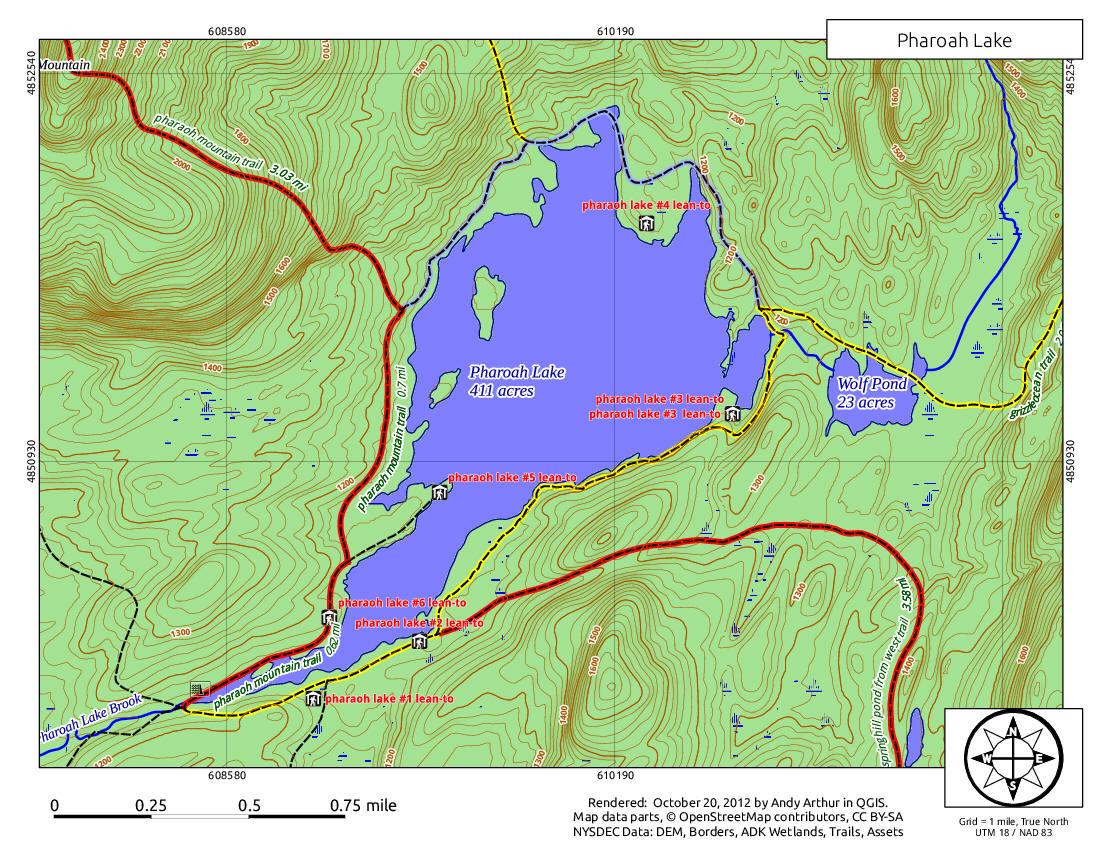
Map above courtesy of Andy Arthur.org
| CNY Hiking HOME PAGE | Pharaoh Mountain | Adirondack Lean To's |
